Pool
Mpumbu, Nsundi or Mbula Ntangu | |
|---|---|
 | |
 Pool, department of the Republic of the Congo | |
| Country | Republic of the Congo |
| Capital | Kinkala |
| Area | |
| • Total | 33,955 km2 (13,110 sq mi) |
| Population (2023 census) | |
| • Total | 394,532 |
| • Density | 12/km2 (30/sq mi) |
| HDI (2018) | 0.484[1] low · 12th of 12 |
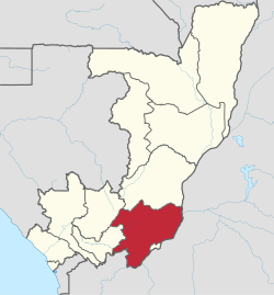
Pool (Kongo: Mpumbu, Nsundi, Mbula Ntangu[2][3]) is a department of the Republic of the Congo in the southeastern part of the country. It borders the departments of Bouenza, Lékoumou, and Plateaux. Internationally, it borders the Democratic Republic of the Congo. It also surrounds the commune district of the national capital, Brazzaville.
The regional capital is Kinkala. Principal towns include Boko, Kindamba and Mindouli. In the early 2000s, the Pool region was the home of a low-level insurgency led by Pasteur Ntumi. The inhabitants of this department are the Kongo, the Téké and the Native population (Pygmies).[4][5]
The region is named after the Pool Malebo (formerly Stanley Pool), a particularly wide stretch of the Congo River here.

Administrative divisions[edit]
Pool Department is divided into thirteen districts:
- Kinkala District
- Boko District
- Mindouli District
- Kindamba District
- Goma Tsé-Tsé District
- Mayama District
- Ngabé District
- Mbanza–Ndounga District
- Louingui District
- Loumo District
- Ignié District
- Vindza District
- Kimba District
References[edit]
- ^ "Sub-national HDI - Area Database - Global Data Lab". hdi.globaldatalab.org. Retrieved 2018-09-13.
- ^ William Graham Lister Randles, L’ancien royaume du Congo des origines à la fin du XIXe siècle, Éditions de l’École des hautes études en sciences sociales, 2013, p. 44
- ^ Jean Félix YEKOKA, L’HOMME ET SA TERRE AU PAYS DE BOKO-SONGHO DU XVIIe AU DEBUT DU XXIe SIECLES, UNIVERSITE MARIEN NGOUABI - FACULTE DES LETTRES ET DES SCIENCES HUMAINES FORMATION DOCTORALE « HISTOIRE ET CIVILISATIONS AFRICAINES » (HCA), 2013, p. 36
- ^ Elisabeth Dorier; Rodrigue Kinouani; Erwan Morand; Damien Rouquier; Quentin Fleuret (2011). "Une zone enclavée en situation post-confit: le district de Kindamba (Pool, République du Congo). Diagnostic territorial dans en vue d'un Projet d'appui au Développement Communautaire". HAL OPEN SCIENCE (in French).
- ^ Roger BOUKA OWOKO; Roch Euloge N’ZOBO; OBSERVATOIRE CONGOLAIS DES DROITS DE L’HOMME (OCDH); UNION EUROPÉENNE (2011). "LES PEUPLES AUTOCHTONES DE LA REPUBLIQUE DU CONGO : DISCRIMINATION ET ESCLAVAGE" (PDF). GITPA.ORG (in French).
3°34′S 14°46′E / 3.567°S 14.767°E