Hollands Kroon | |
|---|---|
 Anna Paulowna town centre | |
 Flag Coat of arms | |
 Location in North Holland | |
| Coordinates: 52°52′N 4°49′E / 52.867°N 4.817°E | |
| Country | Netherlands |
| Province | North Holland |
| Established | 1 January 2012[1] |
| Government | |
| • Body | Municipal council |
| • Mayor | Rian van Dam (PvdA) |
| Area | |
| • Total | 662.20 km2 (255.68 sq mi) |
| • Land | 357.34 km2 (137.97 sq mi) |
| • Water | 304.86 km2 (117.71 sq mi) |
| Elevation | −1 m (−3 ft) |
| Population (January 2021)[4] | |
| • Total | 48,583 |
| • Density | 136/km2 (350/sq mi) |
| Time zone | UTC+1 (CET) |
| • Summer (DST) | UTC+2 (CEST) |
| Postcode | 1730–1736, 1760–1779 |
| Area code | Various |
| Website | www |

Hollands Kroon is a municipality located in the Northwest Netherlands. It was created on 1 January 2012, as a merger of four municipalities: Anna Paulowna, Niedorp, Wieringen, and Wieringermeer.[5]
Localities[edit]
Cities (places/areas with city rights[citation needed]):
Local government[edit]
The municipal council of Hollands Kroon consists of 29 seats, which are divided as follows:
| Municipal council seats | |||
|---|---|---|---|
| Party | 2012 | 2018 [6] | 2022 [7] |
| Senioren Hollands Kroon | 4 | 7 | 4 |
| VVD | 8 | 5 | 4 |
| CDA | 5 | 5 | 5 |
| Onafhankelijk Hollands Kroon | 3 | 8 | |
| PvdA | 4 | 2 | 2 |
| GroenLinks | 1 | 2 | 2 |
| D66 | 1 | 2 | 2 |
| Christian Union | 1 | 1 | |
| LADA (Democratie Anders) | 3 | 1 | |
| ANDERS! | 1 | ||
| Partij Vrije Liberalen | 1 | ||
| Progressief Wieringermeer | 1 | ||
| LADA & ANDERS! | 2 | ||
| Total | 29 | 29 | 29 |
The executive board consists of Onafhankelijk Hollands Kroon, Senioren Hollands Kroon, GroenLinks, Partij van de Arbeid en D66 [8]
Notable people[edit]

- Dirck Pietersz van Nierop (1540 in Nieuwe Niedorp – 1610) a Mennonite minister
- Dirck Rembrantsz van Nierop (1610 in Nieuwe Niedorp – 1682) cartographer, mathematician, surveyor, astronomer and teacher
- Elisabeth van der Woude (1657 in Nieuwe Niedorp – 1698) a Dutch traveller and author
- Hendrik van Borssum Buisman (1873 in Wieringen – 1951) painter
- Pieter Baas (born 1944 in Wieringermeer) a Dutch botanist
- Gerbrand Bakker (born 1962 in Wieringerwaard) a Dutch writer
Sport[edit]

- Albertus Perk (1887 in Anna Paulowna – 1919) a Dutch fencer, competed in the individual épée event at the 1912 Summer Olympics
- Ard Schenk (born 1944 in Anna Paulowna) a former speed skater, silver medallist at the 1968 Winter Olympics and triple gold medallist at the 1972 Winter Olympics
- Henk Schenk (born 1945 in Wieringerwaard) an American former wrestler, competed in the 1968 and 1972 Summer Olympics
- Erik Heijblok (born 1977 in Den Oever, Wieringen) retired football goalkeeper.
- Selma Borst (born 1983 in Wieringerwaard) a Dutch runner
- Kai Reus (born 1985 in Niedorp) a Dutch former professional road bicycle racer
- Jessy Kramer (born 1990 in Zijdewind) a Dutch handball player
- Marit Raaijmakers (born 1999 in Hippolytushoef) a Dutch racing cyclist
Gallery[edit]
-
 Klooster met kerk Nieuwe Niedorp
 -
 Molenkolksluis
 -
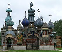 Nederlands Kremlin in Winkel
 -
 Schutsluisje, Nieuwe Niedorp


References[edit]
- ^ "Gemeentelijke indeling op 1 januari 2012" [Municipal divisions on 1 January 2012]. cbs.nl (in Dutch). CBS. Retrieved 9 March 2014.
- ^ "Kerncijfers wijken en buurten 2020" [Key figures for neighbourhoods 2020]. StatLine (in Dutch). CBS. 24 July 2020. Retrieved 19 September 2020.
- ^ "Postcodetool for 1761VM". Actueel Hoogtebestand Nederland (in Dutch). Het Waterschapshuis. Archived from the original on 21 September 2013. Retrieved 9 March 2014.
- ^ "Bevolkingsontwikkeling; regio per maand" [Population growth; regions per month]. CBS Statline (in Dutch). CBS. 1 January 2021. Retrieved 2 January 2022.
- ^ Ministry of the Interior and Kingdom Relations, Samenvoeging van de gemeenten Anna Paulowna, Niedorp, Wieringen en Wieringermeer Archived 2018-06-22 at the Wayback Machine. (Parliamentary document).
- ^ "Kiesraad, Gemeenteraad 21 maart 2018". Retrieved 1 July 2018.
- ^ "Kiesraad Gemeenteraad 16 maart 2022". Retrieved 19 October 2022.
- ^ "Coalitieakkoord". Retrieved 19 October 2022.
External links[edit]
 Media related to Hollands Kroon at Wikimedia Commons
- Official website
Places adjacent to Hollands Kroon | ||||||||||||||||
|---|---|---|---|---|---|---|---|---|---|---|---|---|---|---|---|---|
| ||||||||||||||||

| Authority control databases: National |
|---|