 Tropical Storm Chris making landfall in Louisiana on September 11 | |
| Meteorological history | |
|---|---|
| Formed | September 9, 1982 |
| Dissipated | September 13, 1982 |
| Tropical storm | |
| 1-minute sustained (SSHWS/NWS) | |
| Highest winds | 65 mph (100 km/h) |
| Lowest pressure | 994 mbar (hPa); 29.35 inHg |
| Overall effects | |
| Fatalities | None |
| Damage | $2 million (1982 USD) |
| Areas affected | Texas, Louisiana, Arkansas, Missouri, Illinois, Indiana Tennessee, Kentucky, Mississippi, Alabama, Florida, Georgia, the Carolinas, Ohio, Michigan, New York |
| IBTrACS | |
Part of the 1982 Atlantic hurricane season | |
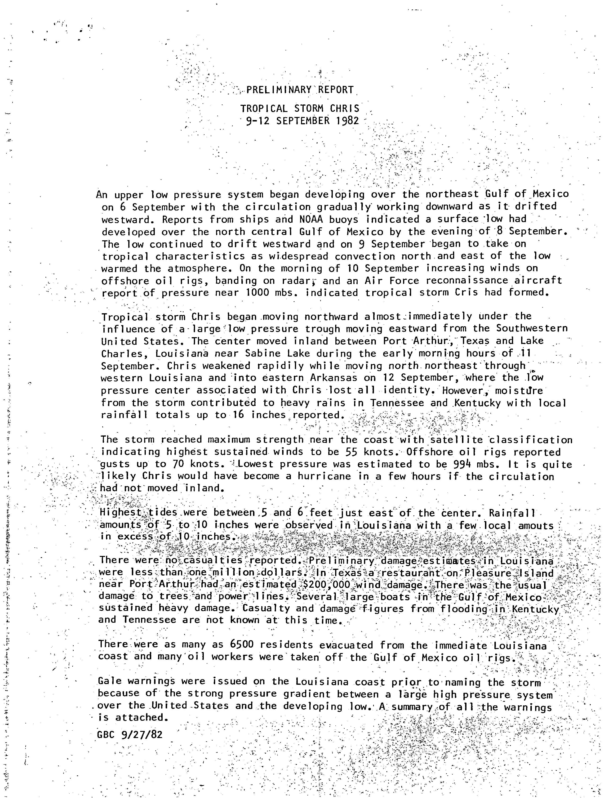
Tropical Storm Chris caused minor flooding along the Gulf Coast of the United States in September 1982. The fifth tropical or subtropical cyclone and third named storm of the 1982 Atlantic hurricane season, Chris developed from a surface low-pressure area in the northern Gulf of Mexico on September 9. Although initially displaying subtropical characteristics, the low pressure area gradually acquired tropical characteristics, and was reclassified as Tropical Depression Four within 24 hours of development. The depression then began to intensify and was upgraded to Tropical Storm Chris on September 10. Thereafter, the storm turned north-north-eastward and strengthened further. On September 11, Chris peaked as a 65 mph (100 km/h) tropical storm. Later that day, it made landfall near Sabine Pass, Port Arthur, Texas. By September 13, Chris dissipated over Arkansas.
When Chris moved ashore, it caused high waves and tides along the shores of the Gulf of Mexico. Though the storm made landfall in Texas, minimal impact was recorded in that state, though a restaurant suffered significant damage. Much of the impact occurred to the east, in Louisiana. Rainfall was relatively light in that state, though a few isolated areas experienced precipitation amounts higher than 15 inches (380 mm). The storm caused steady rainfall in parts of the Midwestern United States. Outside of Louisiana, there were rainfall totals higher than 10 inches (250 mm) in western Tennessee and slightly less than the storm progressed northward. Due to minor flooding, damage in Louisiana was around $1 million (1982 USD). Elsewhere, the impact was limited to mostly light to moderate rainfall, though local flooding was reported in Tennessee and Kentucky. Overall, Chris caused $2 million (1982 USD) in damage and no fatalities.
Meteorological history[edit]

Tropical storm (39–73 mph, 63–118 km/h)
Category 1 (74–95 mph, 119–153 km/h)
Category 2 (96–110 mph, 154–177 km/h)
Category 3 (111–129 mph, 178–208 km/h)
Category 4 (130–156 mph, 209–251 km/h)
Category 5 (≥157 mph, ≥252 km/h)
Unknown
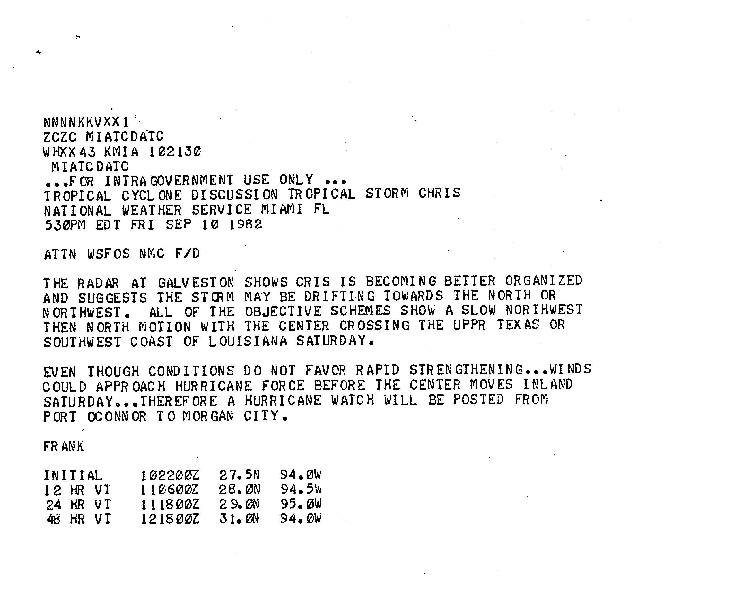
An upper-low pressure system formed in the Gulf of Mexico on September 6, with the circulation heading westward. Initially, minimal development occurred, though by September 8, the system became a surface low. It is estimated that the surface low became a subtropical depression by 0000 UTC on the following day. Over the next 24 hours, the low began acquiring tropical characteristics, mainly from developing deep convection on its north and east sides. By early on September 10, observations from oil rigs, radars, and Air Force reconnaissance flights indicated that the subtropical system had transitioned into Tropical Depression Four.[1] However, the National Hurricane Center did not operationally issue advisories until 1900 UTC on September 10, at which time Chris was already a tropical storm.[1][2]
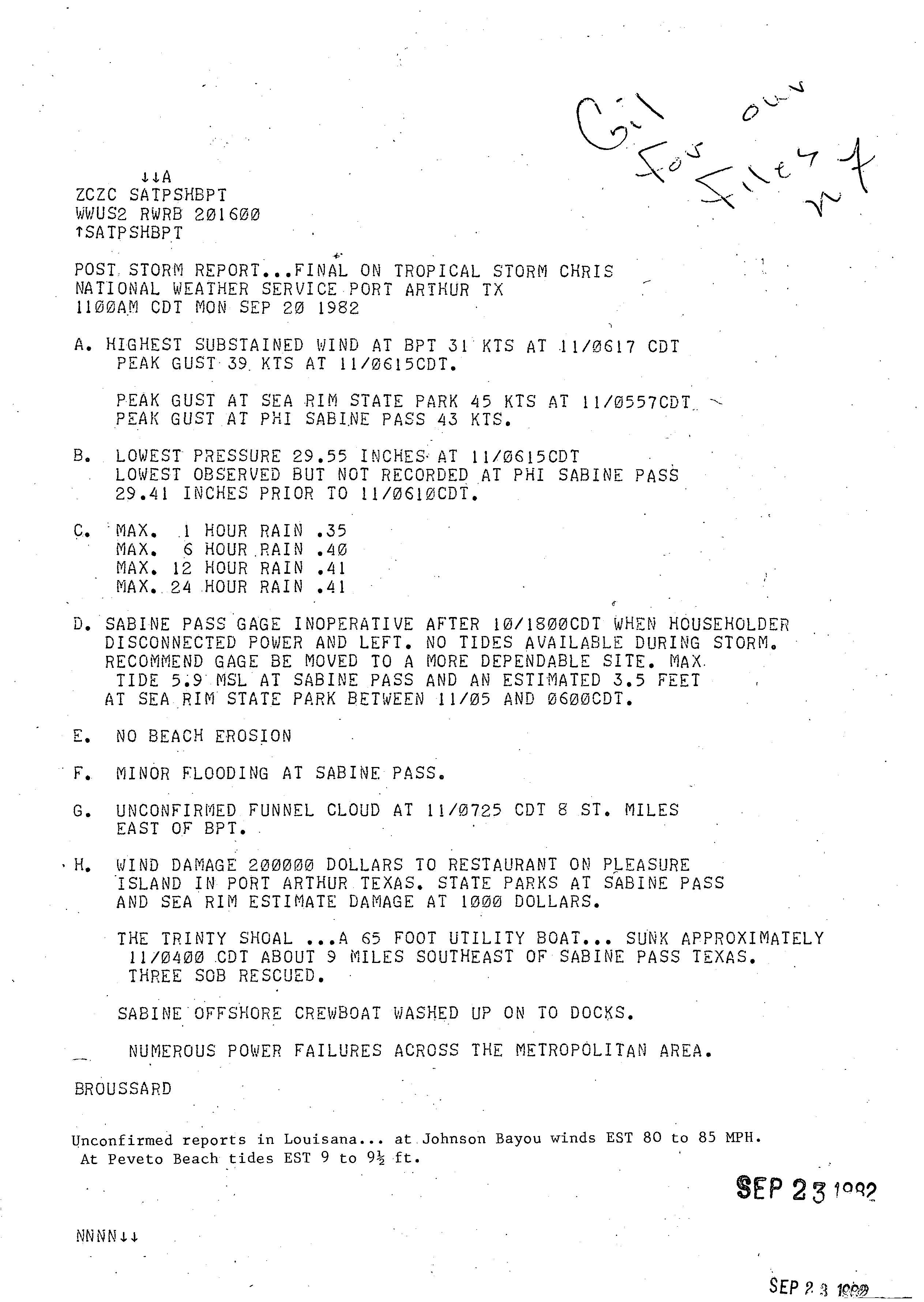
In post-season analysis, it was indicated that Tropical Depression Four strengthened into Tropical Storm Chris at 1200 UTC on September 10. Due to a large low pressure trough over the Southwestern United States, Chris immediately curved northward.[1] Later that day, the National Hurricane Center noted that "even though conditions do not favor rapid strengthening...winds could approach hurricane force before the center moves inland Saturday".[3] As it approached closer to the Gulf Coast of the United States, Chris curved slightly east of north. Shortly before 1200 UTC, Chris made landfall near Sabine Pass, Port Arthur, Texas, with winds of 65 mph (100 km/h). At 1200 UTC on September 11, Chris attained its peak intensity with winds of 65 mph (100 km/h) and a minimum pressure of 994 mbar (29.4 inHg). Chris weakened quickly, and was downgraded to a tropical depression by early on September 12 while centered over west-central Louisiana. The storm deteriorated further, and dissipated in Arkansas at 0000 UTC on September 13. The remnants were last noted over the Midwestern United States.[1]
Preparations[edit]
As Chris approached the Gulf Coast, at least 6,500 people were evacuated from the Louisiana coast.[1] Offshore evacuations were also completed, with many oil rig workers were taken off of rigs in the Gulf of Mexico.[1]
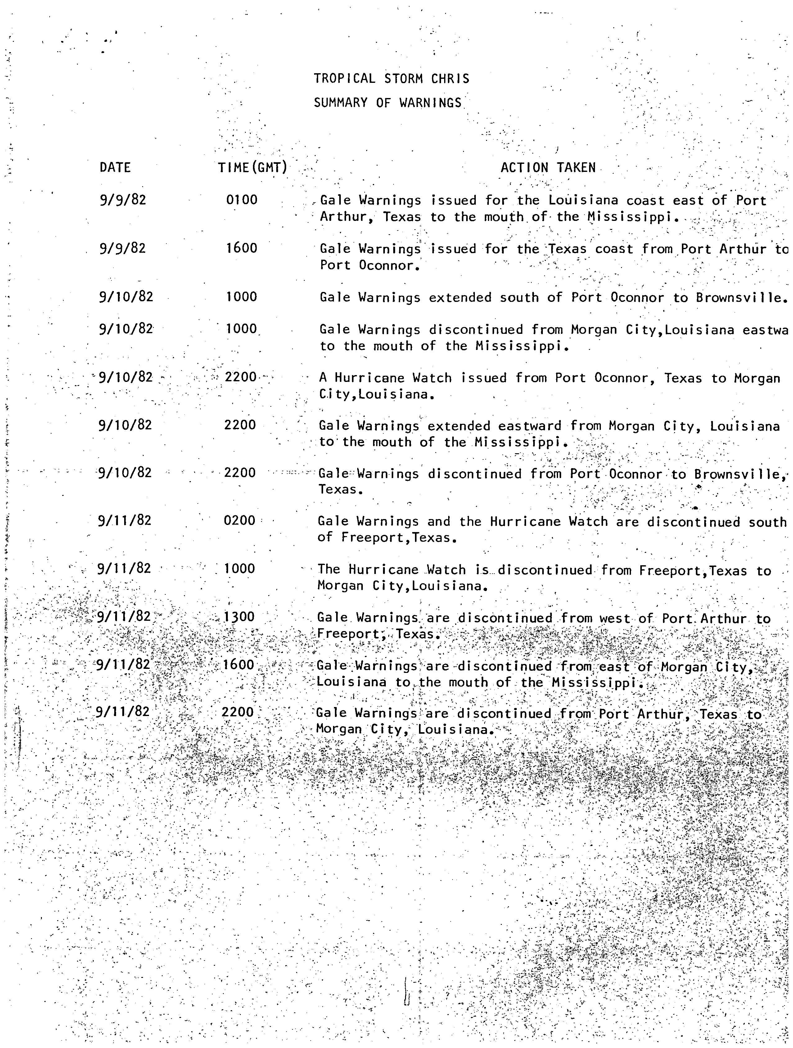
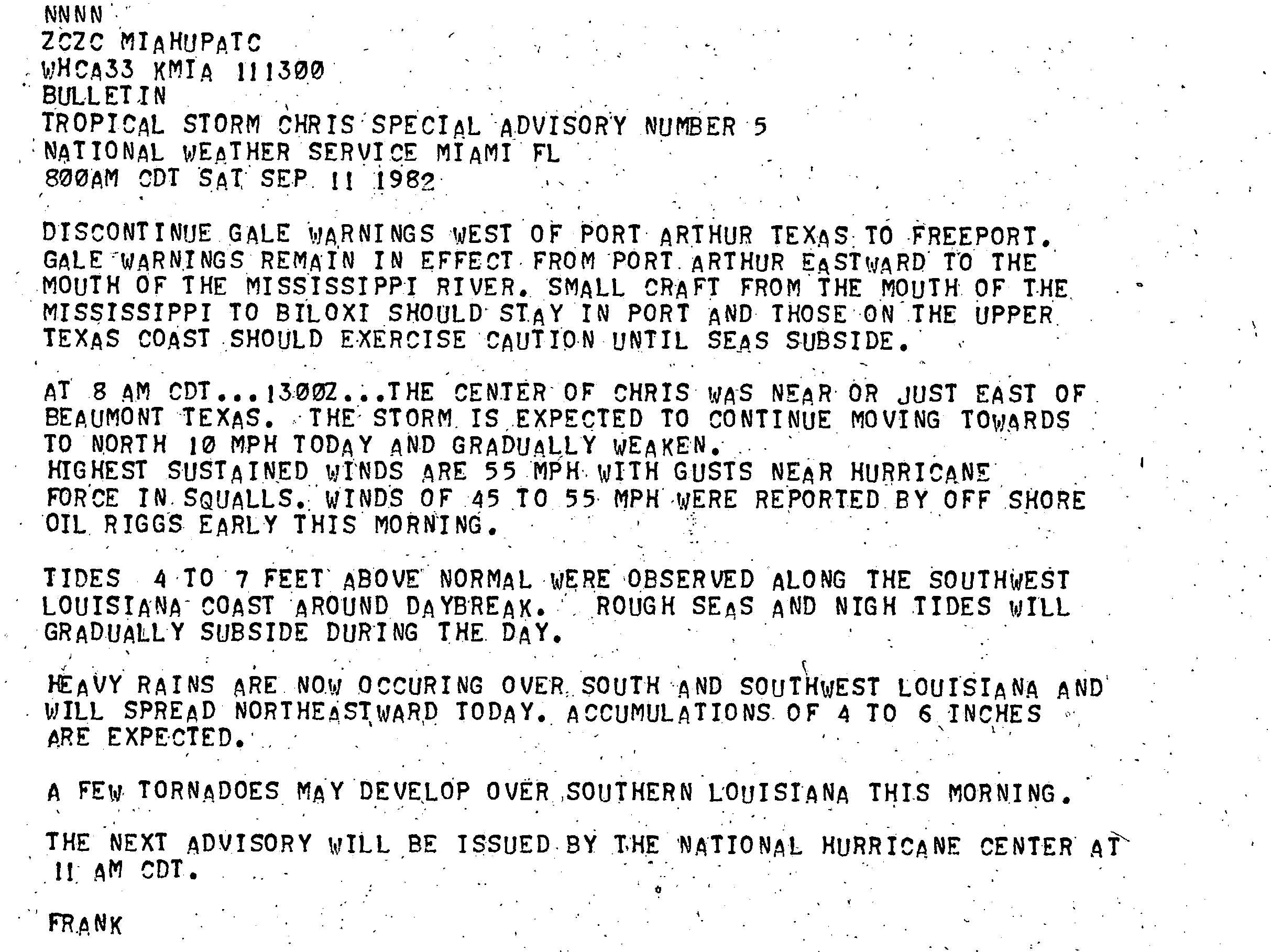
Along with the evacuations, multiple watches and warnings were issued in accordance with Tropical Storm Chris. The first was on September 9, when a gale warning was released for the Louisiana area east of Port Arthur, Texas. Fifteen hours afterwards, a gale warning was released for Port Arthur to Port O'Connor, Texas. The next day, the gale warnings in Texas were extended as far south as Brownsville. A hurricane watch was released at 2200 UTC on September 10 for Morgan City, Louisiana to Port O'Connor, Texas. All watches and warnings were discontinued by 2200 UTC on September 11, which was about 10 hours after Chris made landfall.[4]
Impact[edit]

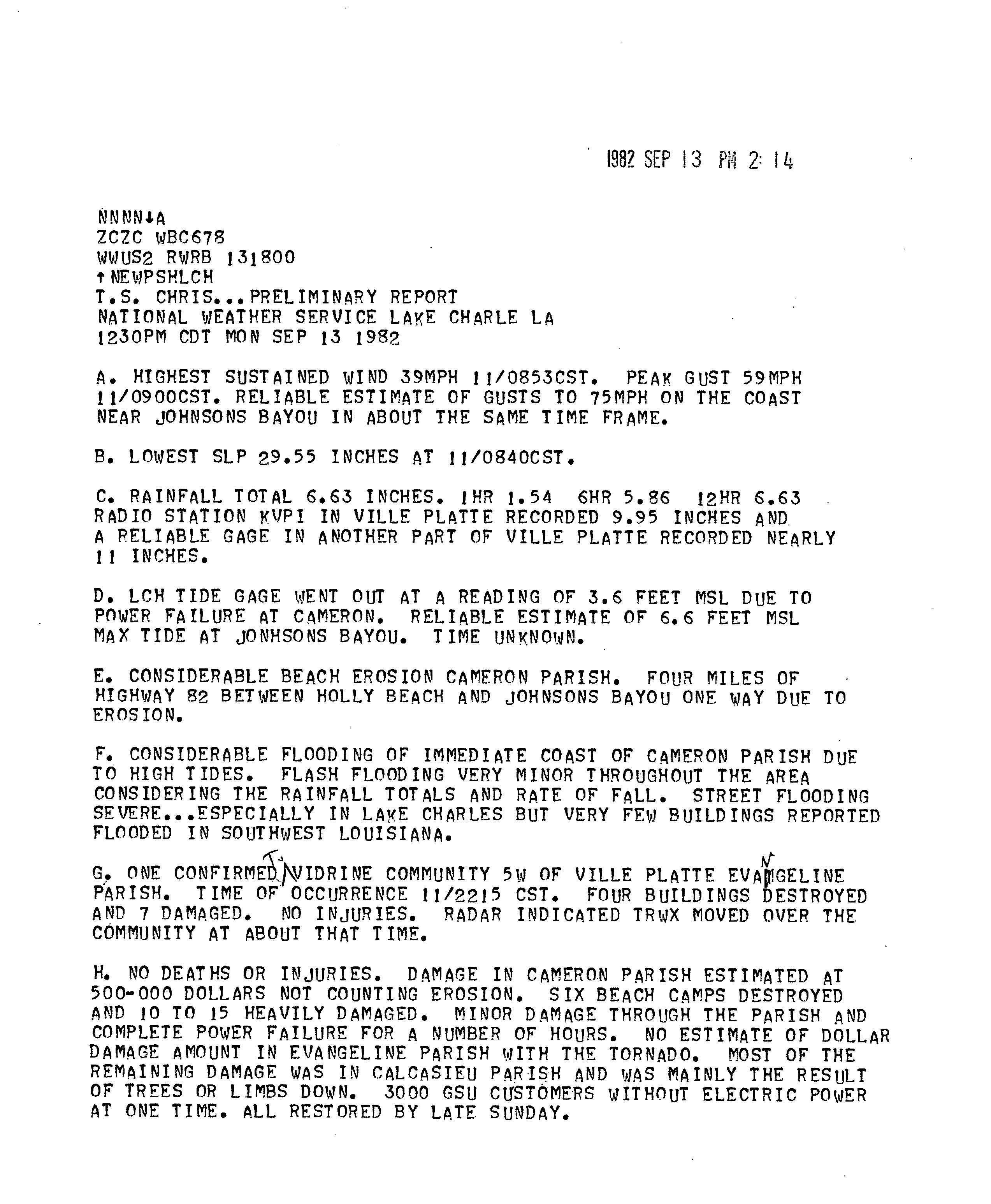
At an offshore oil rig, a wind gust up to 81 mph (130 km/h) was reported. In addition, several boats in the Gulf of Mexico sustained heavy damage.[1] About 9 miles (14 km) southeast of Sabine Pass, a 65 feet (20 m) utility boat sunk.[5] Minimal rainfall was reported in Texas, reaching about 1 inch (25 mm).[6] Winds were light, remaining below tropical storm force in eastern Texas.[5] However, a restaurant on Pleasure Island suffered an estimated $200,000 in damage (1982 USD).[1] In addition, minimal damage occurred at Sea Rim State Park, totaling to only $1,000 (1982 USD). In the Port Arthur area, numerous power outages were reported.[5] Flooded roads and power outages were reported in Beaumont, though damage was not significant in that city.[7]
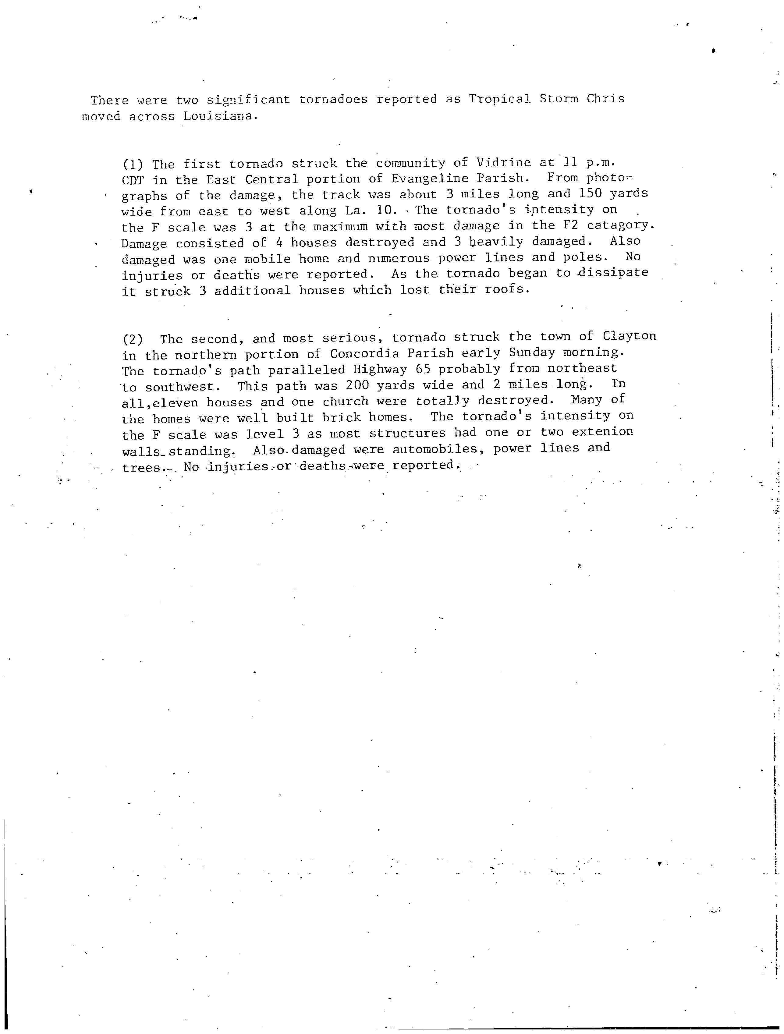
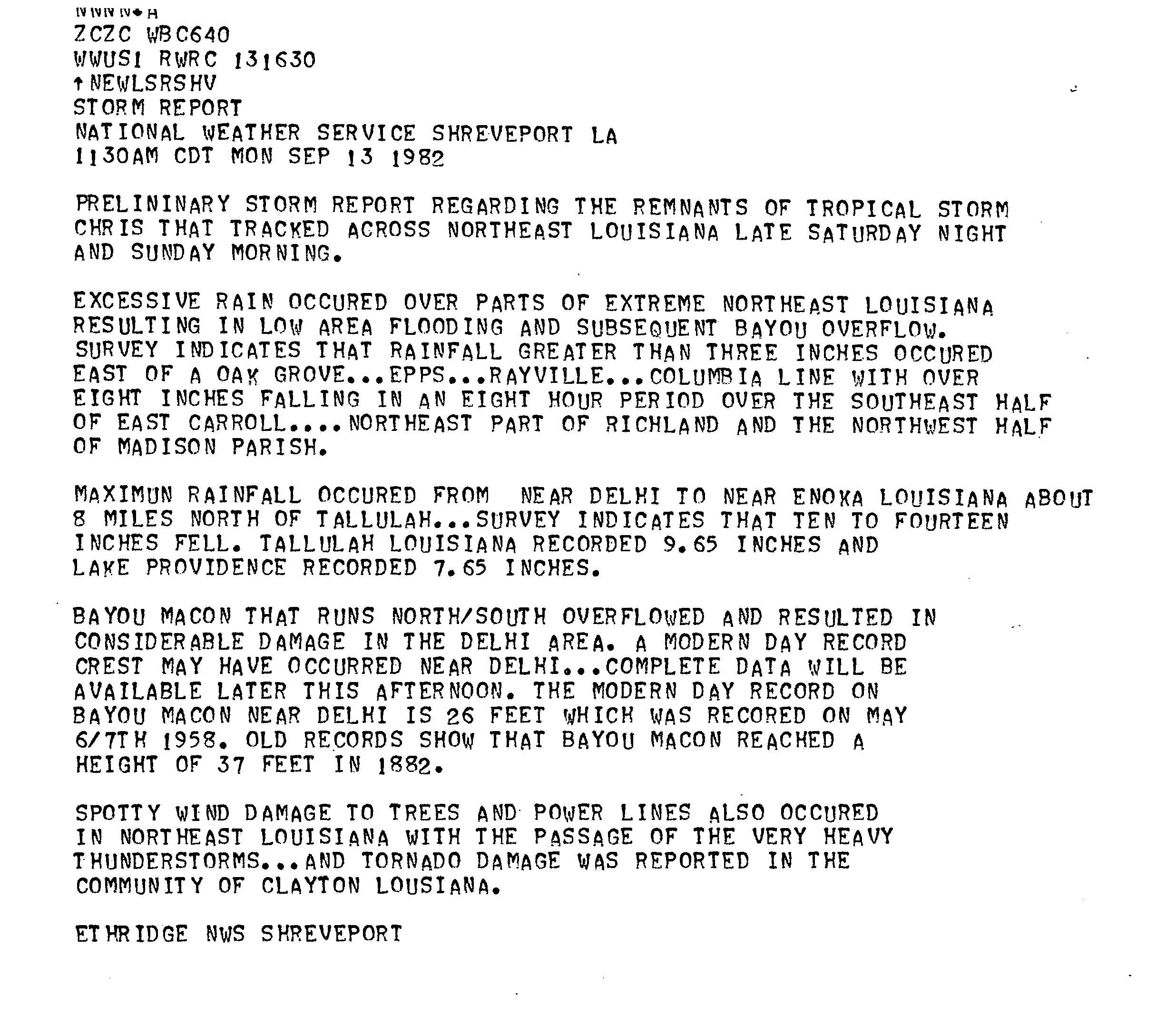
Along the southwestern coast of Louisiana, tides between 4 and 7 feet (1.2 and 2.1 m) were reported.[8] On land, Chris produced tropical storm force winds in a few areas and light to moderate rainfall.[1] Throughout the state, precipitation was generally between 5 and 10 inches (130 and 250 mm), though speaking at more than 16 inches (410 mm) in Delhi.[6] Elsewhere in Louisiana, about 5 inches (130 mm) of rainfall was reported in Lake Charles.[6][9] Street flooding in Lake Charles was severe, though only a few houses suffered flood damage. To the south of Lake Charles, minor damage was reported in Cameron Parish, totaling to about $500,000 (1982 USD). However, due to high tides, damage along the coastal areas of that parish was considerable.[10] A Cameron Parish official noted, "There's power out all over the place, and we understand there was quite a bit of damage at Holly Beach".[7] In Evangeline Parish, an F2 tornado on the Fujita Scale destroyed four buildings and damaged seven other structures.[11] In northeastern Louisiana, wind damage was "spotty" and limited to downed trees and powerlines. As a result of heavy rainfall in that portion of the state, low-lying areas flooded and bayous overflowed.[12] A tornado, rated at F3, destroyed eleven houses and one church in Clayton. In addition, the tornado knocked down trees and powerlines in the area.[11] Overall, damage in Louisiana was near $1 million (1982 USD).[1]
Throughout Louisiana and Mississippi, a combined total of nine tornadoes was reported.[13] One of the tornadoes in Mississippi damaged several homes and businesses in Cleveland, and at least four injuries were reported. Another tornado spawned in a rural area overturned a mobile home in Eden. Two other twisters in the state caused minimal damage.[14] In Mississippi, rains peaked at about 10 inches (250 mm) in the northwest section of the state. The rest of the state reported widespread rains of 1–7 inches (25–178 mm). Rainfall in Alabama peaked at 3 inches (76 mm) in some areas, and similar amounts were observed in Georgia.[6] In Florida, rainfall peaked at 7 inches (180 mm) in an extremely southern part of the Panhandle. Precipitation was also recorded in Lake Okeechobee, with 1 inch (25 mm) reported there. The northeastern section of the state reported 5 inches (130 mm) of rain. No rain was reported in the Florida Keys.[6]
In Arkansas, only 1 inch (25 mm) of rain was reported, which was in several portions of the state. Missouri reported a peak of 5 inches (130 mm) of precipitation in the southeastern portion of the state. Other rains in the state include 1–3 inches (25–76 mm), which was widespread.[6] Illinois reported mainly 1 inch (25 mm) of precipitation, with one area of 3 inches (76 mm), all in the southern half of the state. Very little rain was reported in Indiana, with only 1-inch (25 mm) on the southern border of the state. In Tennessee and Kentucky, rains of 10–16 inches (250–410 mm) were reported with locally heavy flooding.[6][15] The western portions of Tennessee reported flood waters at least waist high in some city streets. In addition, schools in Milan were closed, while portions of U.S. Routes 70 and 79 were submerged into water. A few businesses in the city of Huntington suffered flood damage.[16] Other rains include 1 inch (25 mm) in the Carolinas, New York, Michigan, Virginia and Ohio.[6] Overall, damage from Tropical Storm Chris was slightly less than $2 million (1982 USD),[17] and no fatalities were reported.[1]
See also[edit]
References[edit]
- ^ a b c d e f g h i j k Gilbert B. Clark (1982-09-27). "Tropical Storm Chris Preliminary Report (Page 1)". National Hurricane Center. Retrieved 2012-01-01.
- ^ Neil L. Frank (1982-09-10). "Tropical Storm Chris Special Advisory Number 1". National Hurricane Center. Retrieved 2012-01-01.
- ^ Neil L. Frank (1982-09-10). "Tropical Cyclone Discussion: Tropical Storm Chris". National Hurricane Center. Retrieved 2012-01-01.
- ^ Gilbert B. Clark (1982-09-27). "Tropical Storm Chris Preliminary Report - Summary of warnings". National Hurricane Center. Retrieved 2012-01-01.
- ^ a b c Broussard (1982-09-20). "Post Storm Report...Final On Tropical Storm Chris". National Weather Service Port Arthur, Texas. National Hurricane Center. Retrieved 2012-01-01.
- ^ a b c d e f g h David M. Roth (2007-05-16). "Tropical Storm Chris - September 8-14, 1982". Hydrometeorological Prediction Center. Retrieved 2012-01-01.
- ^ a b "Tropical Storm Soaks Louisiana". Reading Eagle. Associated Press. 1982-09-12. Retrieved 2012-01-02.
- ^ Neil L. Frank (1982-09-11). "Tropical Storm Chris Advisory Number 5". National Hurricane Center. Retrieved 2012-01-01.
- ^ "Chris drenches Louisiana". Syracuse Herald Journal. Associated Press. 1982.
{{cite web}}: Missing or empty|url=(help) - ^ "T.S. Chris...Preliminary Report". National Weather Service Lake Charles, LA. National Hurricane Center. 1982-09-13. Retrieved 2012-01-01.
- ^ a b "Tropical Storm Chris - Tornadoes". National Hurricane Center. 1982. Retrieved 2012-01-01.
- ^ Ethridge (1982-09-13). "Storm Report". National Weather Service Shreveport, LA. National Hurricane Center. Retrieved 2012-01-01.
- ^ Tom Grazulis of The Tornado Project and Bill McCaul of USRA Huntsville (2008). "List of Known Tropical Cyclones Which Have Spawned Tornadoes". Tornado Project. Retrieved 2012-01-01.
- ^ United Press International (1982-09-13). "Tornadoes lash across Mississippi". Lodi News-Sentinel. Retrieved 2012-01-02.
- ^ U.S. Geological Survey Kansas Water Science Center (2008-09-17). "Summary of Significant Floods in the United States, Puerto Rico, and the Virgin Islands, 1970 Through 1989 - 1982". U.S. Geological Survey Kansas Water Science Center. Retrieved 2012-01-01.
- ^ "Tornadoes Hit Three States; Early Snow Surprises Montana". The Palm Beach Post. Associated Press. 1982-09-14. Retrieved 2012-01-02.
- ^ Gilbert B. Clark (May 1983). "Atlantic Hurricane Season of 1982" (PDF). National Hurricane Center. Retrieved 2012-01-01.
External links[edit]
- Monthly Weather Review
- Detailed information on all storms from 1982[permanent dead link]
- Poststorm Reconnaissance of Tropical Storm Chris
Tropical cyclones of the 1982 Atlantic hurricane season | ||
|---|---|---|
 | ||