Sutherland Springs, Texas | |
|---|---|
[[File:Historic American Buildings Survey, Arthur W. Stewart, Photographer April 28, 1936 SOUTHWEST ELEVATION (WEST FRONT AND SOUTH SIDE). - Whitehall, Farm Road 539, Sutherland HABS TEX,247-SUSPR.V,1-2.tif|250px|alt=Historic building in Sutherland Springs|Historic building in Sutherland Springs


45km 30miles
Sutherland Springs [[file:Map of USA without state names.svg|120px|alt=  |link=]] |link=]]Historic building in Sutherland Springs
45km 30miles
Sutherland Springs  | |
| Coordinates: 29°16′24″N 98°03′24″W / 29.27333°N 98.05667°W | |
| Country | United States |
| State | Texas |
| County | Wilson |
| Established | 1854 |
| Founded by | John Sutherland |
| Elevation | 469 ft (143 m) |
| Population (2017) | |
| • Total | 600 |
| Time zone | UTC-6 (CST) |
| ZIP code | 78161 |
| Website | Handbook of Texas |
Sutherland Springs is an unincorporated community located on the old Spanish land grant of Manuel Tarin in northern Wilson County, Texas, United States. It is located on U.S. Highway 87 at the intersection of Farm to Market Road 539.
On November 5 2017, Sutherland Springs local church became the scene of the deadliest shooting in a place of worship in the United States when 26 people (including an unborn child) were killed and 22 other were injured, before the shooter committed suicide.
History[edit]

Sutherland Springs was platted in 1854, and named after John Sutherland Jr., a pioneer citizen.[2] A post office has been in operation at Sutherland Springs since 1851.[3]
2017 shooting[edit]
On November 5, 2017, Devin Patrick Kelley shot 26 people dead and injured 22 at the community's First Baptist Church. The gunfire was heard by Stephen Willeford, a church neighbor and former NRA instructor, who grabbed his weapon and ran toward the scene barefoot.[4][5] Willeford seriously wounded Kelley in a rapid exchange of gunfire, then corralled a nearby car and chased Kelley as he tried to flee the scene in his truck. After a high-speed chase, Kelley succumbed to a self-inflicted gunshot wound to the head. He was found dead in a roadside ditch.[4] It was the deadliest mass shooting in Texas history, surpassing the Luby's shooting in October 1991 and the fifth deadliest mass shooting in the history of the United States.[6] [7]
Geography[edit]
Old Sutherland Springs occupies a portion of the south bank of Cibolo Creek, with New Sutherland Springs (which is mostly in ruins) on the north bank of the creek.[citation needed]
Bibliography[edit]
- The Good Old Days: A History of LaVernia was published by members of the civic government class at LaVernia High School for the 1936-37 academic school year.
- Wilson County Centennial 1860-1960 was published by the Wilson County Library; it is the official centennial program handed out by the local community for the "100-year celebration" of the county's establishment.
References[edit]
- ^ "Sutherland Springs". Geographic Names Information System. United States Geological Survey, United States Department of the Interior.
- ^ McCaslin, Richard. "Sutherland Springs, TX". tshaonline.org. Texas State Historical Association. Retrieved August 3, 2016.
- ^ "Post Offices". Postalhistory.com. Retrieved November 6, 2017.
- ^ a b "Texas Church Shooting". The Guardian. November 7, 2017.
- ^ Killough, Ashley; LeBlanc, Paul (July 7, 2021). "Federal judge largely faults Air Force for 2017 Texas church shooting". Cnn.com. Retrieved July 9, 2021.
- ^ "Sutherland Springs: Texas church shooting leaves 26 dead". BBC News. November 5, 2017.
- ^ Saeed Ahmed. "2 of the 5 deadliest mass shootings in modern US history happened in the last 35 days". Cnn.com. Retrieved February 9, 2022.
External links[edit]
- Sutherland Springs Museum
- A Guide to Sutherland Springs
- Handbook of Texas on Sutherland Springs
- U.S. Geological Survey Geographic Names Information System: Sutherland Springs, Texas
Municipalities and communities of Wilson County, Texas, United States | ||
|---|---|---|
| Cities | 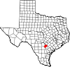 | |
| Town | ||
| Unincorporated communities | ||
| Ghost towns | ||
| Footnotes | ‡This populated place also has portions in an adjacent county or counties | |
| International | |
|---|---|
| National | |