 The square in 2017, looking northwest | |
| Namesake | Battle of New Orleans |
|---|---|
| Maintained by | City of Savannah |
| Location | Savannah, Georgia, U.S. |
| Coordinates | 32°04′35″N 81°05′43″W / 32.0763°N 81.0954°W |
| North | Barnard Street |
| East | West McDonough Street |
| South | Barnard Street |
| West | West McDonough Street |
| Construction | |
| Completion | 1815 |
Orleans Square is one of the 22 squares of Savannah, Georgia, United States. It is located in the middle row of the city's five rows of squares, on Barnard Street and West McDonough Street, and was laid out in 1815, shortly after the event it commemorates: General Andrew Jackson's victory at the Battle of New Orleans that January. It is south of Telfair Square, west of Chippewa Square and north of Pulaski Square. The oldest building on the square is the John Ash House, at 114–116 West Hull Street, which dates to 1817.[1]
In the center of the square, the German Memorial Fountain honors early German immigrants to Savannah.[2] Installed in 1989, it commemorates the 250th anniversary of Georgia and of Savannah, as well as the 300th anniversary of the arrival in Philadelphia of thirteen Rhenish families.[3]
Between 1820 and 1916, the Bulloch–Habersham House stood in the square. It was designed by William Jay.[4] Its demolition was described by historian John D. Duncan as "one of the worst cases of metropolitan malfeasance to be documented in an era when the preservation movement was just beginning to gain attention."[5]
Dedication[edit]
| Namesake | Image | Note |
|---|---|---|
| Battle of New Orleans | 
|
The square is named for the Battle of New Orleans, 1815, in which the United States Army were victorious. |
Markers and structures[edit]
| Name | Image | Note |
|---|---|---|
| German Memorial Fountain | 
|
German Memorial Fountain in the square, completed in 1989. |
| German Memorial Fountain marker | 
|
German Memorial Fountain marker, erected and dedicated by the descendants of Savannah's early German settlers. |
Constituent buildings[edit]
Each building below is in one of the eight blocks around the square composed of four residential "tything" blocks and four civic ("trust") blocks, now known as the Oglethorpe Plan. They are listed with construction years where known.
- Northwestern residential/tything block
- Oglethorpe House, 201 West Oglethorpe Avenue (1964)[1] – formerly the Downtowner Motor Inn
- Southwestern residential/tything block
- Frederick Tebeau House, 101 West Perry Street (1836) – remodeled in 1876; moved from 16 West Liberty Street in the 1980s
- John Martin/A.J. Miller Duplex, 105–107 West Perry Street (1872) – by DeWitt Bruyn
- Laura Mehrtens House, 109 West Perry Street (1904)
- Mordecai Myers House, 111 West Perry Street (1833) – third floor added c. 1880
- Henry Hayme Duplex, 113–115 West Perry Street (1887) – by Calvin Fay and Alfred Eichberg
- John Morel Property, 117–119 West Perry Street (1818) – remodeled in 1875
- Northeastern residential/tything block
- John Ash House, 114–116 West Hull Street (1817)[1] – oldest building on the square
- Southeastern civic/trust block
- Harper Fowlkes House, 230 Barnard Street (1844)[1]
Gallery[edit]
-
 Frederick Tebeau House, 101 West Perry Street
 -
 John Martin/A.J. Miller Duplex, 105–107 West Perry Street
 -
 Laura Mehrtens House, 109 West Perry Street
 -
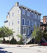
 Mordecai Myers House, 111 West Perry Street
 -
 Henry Hayme Duplex, 113–115 West Perry Street
 -
 John Morel Property, 117-119 West Perry Street
 -
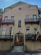
 The Harper Fowlkes House, 230 Barnard Street
 -
 John Ash House, 114–116 West Hull Street
 -
 The former Downtowner Motor Inn, 201 West Oglethorpe Avenue, now home to SCAD's Oglethorpe House


References[edit]
- ^ a b c d Historic Building Map: Savannah Historic District – Historic Preservation Department of the Chatham County-Savannah Metropolitan Planning Commission (November 17, 2011), p. 36
- ^ Tour Guide Manual for licensed tour guides in the City of Savannah, accessed June 16, 2007.
- ^ City of Savannah's monuments page This page links directly to numerous short entries, many accompanied by photographs, discussing a variety of monuments, memorials, etc., in the squares and elsewhere. Accessed June 16, 2007.
- ^ "CONTENTdm". vault.georgiaarchives.org. Retrieved 2023-07-06.
- ^ Dawers, Bill. "New book on architect William Jay has contemporary relevance". Savannah Morning News. Retrieved 2023-10-18.