New Hampton, New Hampshire | |
|---|---|
Town | |
 New Hampton Community Church | |
 Location in Belknap County, New Hampshire | |
| Coordinates: 43°36′19″N 71°39′10″W / 43.60528°N 71.65278°W | |
| Country | United States |
| State | New Hampshire |
| County | Belknap |
| Incorporated | 1777 |
| Government | |
| • Board of Selectmen |
|
| • Town Administrator | Neil G. Irvine |
| Area | |
| • Total | 38.4 sq mi (99.4 km2) |
| • Land | 36.8 sq mi (95.2 km2) |
| • Water | 1.6 sq mi (4.2 km2) 4.19% |
| Elevation | 525 ft (160 m) |
| Population (2020)[2] | |
| • Total | 2,377 |
| • Density | 65/sq mi (25.0/km2) |
| Time zone | UTC-5 (Eastern) |
| • Summer (DST) | UTC-4 (Eastern) |
| ZIP code | 03256 |
| Area code | 603 |
| FIPS code | 33-51540 |
| GNIS feature ID | 0873679 |
| Website | www |
New Hampton is a town in Belknap County, New Hampshire, United States. The population was 2,377 at the 2020 census.[2] A winter sports resort area, New Hampton is home to George Duncan State Forest and to the New Hampton School, a private preparatory school established in 1821.
The primary village in town, where 373 people resided at the 2020 census,[3] is defined as the New Hampton census-designated place, and is located along New Hampshire Route 132, just south of its intersection with Route 104.
History[edit]
Granted in 1765 by colonial Governor Benning Wentworth, New Hampton was originally known as "Moultonborough Addition", after then-Colonel Jonathan Moulton, who held the position of town moderator. Moulton, who was born in Hampton, changed the name to New Hampton in 1777 when it was incorporated.[4]
In 1821 the New Hampton School, a Free Will Baptist institution, was founded in the town. From 1854 to 1870, the institute was affiliated with Cobb Divinity School (later part of Bates College).
In 1920, the New Hampton Fish Hatchery, the state's oldest fish hatchery, was established in the town.
-
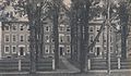
 Lewis Mansion in 1909
 -
 Berry Hall c. 1912
 -
 Randall Hall c. 1910
 -
 Gordon-Nash Library c. 1915


Geography[edit]
According to the United States Census Bureau, the town has a total area of 38.4 square miles (99.4 km2), of which 36.8 sq mi (95.2 km2) are land and 1.6 sq mi (4.2 km2) are water, comprising 4.19% of the town.[1] New Hampton is bounded on the west and southwest by the Pemigewasset River. Pemigewasset Lake is in the center, and Winona Lake and Lake Waukewan are in the northeast. The highest point in New Hampton is 1,840 feet (561 m) above sea level atop the west ridge of Hersey Mountain, whose 2,001-foot (610 m) summit lies just over the town boundary in Sanbornton.
The geographic center of New Hampshire is located in the eastern part of New Hampton, between Winona Lake and Jackson Pond, at 43.67925 N, 71.580375 W.[5]
The town is served by Interstate 93 and state routes 104 and 132. I-93 serves the town at Exit 23 and leads north to Plymouth and south to Concord. NH 104 passes east–west through the town, connecting Bristol to the west with Meredith to the east. NH 132 parallels I-93 as a local road, connecting Sanbornton and Tilton to the south with Ashland to the north.
Adjacent municipalities[edit]
- Ashland (north)
- Center Harbor (northeast)
- Meredith (east)
- Sanbornton (south)
- Hill (southwest)
- Bristol (west)
- Bridgewater (northwest)
Demographics[edit]
| Census | Pop. | Note | %± |
|---|---|---|---|
| 1790 | 652 | — | |
| 1800 | 1,095 | 67.9% | |
| 1810 | 1,293 | 18.1% | |
| 1820 | 1,500 | 16.0% | |
| 1830 | 1,904 | 26.9% | |
| 1840 | 1,812 | −4.8% | |
| 1850 | 1,612 | −11.0% | |
| 1860 | 1,596 | −1.0% | |
| 1870 | 1,257 | −21.2% | |
| 1880 | 1,059 | −15.8% | |
| 1890 | 935 | −11.7% | |
| 1900 | 852 | −8.9% | |
| 1910 | 821 | −3.6% | |
| 1920 | 708 | −13.8% | |
| 1930 | 692 | −2.3% | |
| 1940 | 791 | 14.3% | |
| 1950 | 723 | −8.6% | |
| 1960 | 862 | 19.2% | |
| 1970 | 946 | 9.7% | |
| 1980 | 1,249 | 32.0% | |
| 1990 | 1,606 | 28.6% | |
| 2000 | 1,950 | 21.4% | |
| 2010 | 2,165 | 11.0% | |
| 2020 | 2,377 | 9.8% | |
| U.S. Decennial Census[6] | |||
As of the 2010 census, there were 2,165 people, 848 households, and 617 families residing in the town. There were 1,083 housing units, of which 235, or 21.7%, were vacant. 185 of the vacant units were for seasonal or recreational use. The racial makeup of the town was 96.9% White, 0.4% African American, 0.1% Native American, 0.8% Asian, 0.0% Native Hawaiian or Pacific Islander, 0.05% some other race, and 1.8% from two or more races. 1.1% of the population were Hispanic or Latino of any race.[7]
Of the 848 households, 30.4% had children under the age of 18 living with them, 60.4% were headed by married couples living together, 7.5% had a female householder with no husband present, and 27.2% were non-families. 21.0% of all households were made up of individuals, and 8.2% were someone living alone who was 65 years of age or older. The average household size was 2.49, and the average family size was 2.86.[7]
In the town, 22.5% of the population were under the age of 18, 5.2% were from 18 to 24, 25.8% from 25 to 44, 31.1% from 45 to 64, and 15.5% were 65 years of age or older. The median age was 42.4 years. For every 100 females, there were 105.0 males. For every 100 females age 18 and over, there were 102.4 males.[7]
For the period 2011–2015, the estimated median annual income for a household was $74,009, and the median income for a family was $73,913. Male full-time workers had a median income of $49,138 versus $43,250 for females. The per capita income for the town was $28,267. 6.6% of the population and 3.3% of families were below the poverty line. 8.3% of the population under the age of 18 and 13.0% of those 65 or older were living in poverty.[8]
Government[edit]
In the New Hampshire Senate, New Hampton is in the 2nd district, represented by Republican Bob Giuda. On the New Hampshire Executive Council, New Hampton is in the 1st district, represented by Republican Joseph Kenney. In the United States House of Representatives, New Hampton is in New Hampshire's 1st congressional district, represented by Democrat Chris Pappas.
Education[edit]
New Hampton is within the Newfound Area School District.[9] New Hampton Community School is in New Hampton. The district's secondary schools are Newfound Memorial Middle School and Newfound Regional High School, both located in Bristol.
Sites of interest[edit]
- Dana Meeting House (c. 1800)
- Gordon-Nash Library (c. 1895)
- New Hampton Town House (c. 1798)
- New Hampton Community Church
Notable people[edit]
- Mary W. Bacheler (1860–1939), physician; medical missionary in India
- Oliver Blake (1802–1873), businessman, Liberal member of the Senate of Canada
- Adoniram Judson Gordon (1836–1895), minister; founder and namesake of Gordon College
- Orren C. Moore (1839–1893), US congressman
- Simon W. Robinson (1792–1868), War of 1812 soldier, businessman
- Darius Songaila (born 1978), professional basketball player; attended New Hampton School
- Ernest Thompson (born 1949), author (On Golden Pond) (summer resident)
References[edit]
- ^ a b "2020 U.S. Gazetteer Files – New Hampshire". United States Census Bureau. Retrieved October 28, 2021.
- ^ a b "New Hampton town, Belknap County, New Hampshire: 2020 DEC Redistricting Data (PL 94-171)". U.S. Census Bureau. Retrieved October 28, 2021.
- ^ "New Hampton CDP, New Hampshire: 2020 DEC Redistricting Data (PL 94-171)". U.S. Census Bureau. Retrieved October 28, 2021.
- ^ Coolidge, Austin J.; John B. Mansfield (1859). A History and Description of New England. Boston, Massachusetts: A.J. Coolidge. pp. 597–598.
coolidge mansfield history description new england 1859.
- ^ "NH Office of Energy and Planning official site - 'Geographic Center of NH'". Archived from the original on November 21, 2006. Retrieved November 8, 2006.
- ^ "Census of Population and Housing". Census.gov. Retrieved June 4, 2016.
- ^ a b c "Profile of General Population and Housing Characteristics: 2010 Census Summary File 1 (DP-1): New Hampton town, Belknap County, New Hampshire". U.S. Census Bureau, American Factfinder. Archived from the original on February 14, 2020. Retrieved October 25, 2017.
- ^ "Selected Economic Characteristics: 2011-2015 American Community Survey 5-Year Estimates (DP03): New Hampton town, Belknap County, New Hampshire". U.S. Census Bureau, American Factfinder. Archived from the original on February 13, 2020. Retrieved October 25, 2017.
- ^ "Central Office". Newfound Area School District. Retrieved April 11, 2020.
External links[edit]
- Official website
- Gordon-Nash Library
- New Hampton Historical Society
- New Hampshire Economic and Labor Market Information Bureau Profile
- New Hampton School
- New Hampshire State Fish Hatcheries & Visitors Centers
Places adjacent to New Hampton, New Hampshire | |
|---|---|
Municipalities and communities of Belknap County, New Hampshire, United States | ||
|---|---|---|
| City |  | |
| Towns | ||
| CDPs | ||
| Other villages | ||
| Footnotes | ‡This populated place also has portions in an adjacent county or counties | |
| International | |
|---|---|
| National | |