Size of this JPG preview of this TIF file: 647 × 600 pixels. Other resolutions: 259 × 240 pixels | 518 × 480 pixels | 829 × 768 pixels | 1,105 × 1,024 pixels | 2,210 × 2,048 pixels | 4,660 × 4,318 pixels.
Original file (4,660 × 4,318 pixels, file size: 115.21 MB, MIME type: image/tiff)
Summary
| Description |
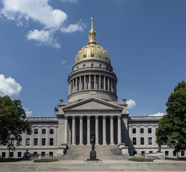
English: Title: The West Virginia Capitol in Charleston
Physical description: 1 photograph : digital, tiff file, color. Notes: Purchase; Carol M. Highsmith Photography, Inc.; 2015; (DLC/PP-2015:055).; For several years, the capital of West Virginia intermittently traveled between Wheeling and Charleston. In 1877, however, the state's citizens voted on the final location of their capital. Charleston was chosen and, eight years later, the first capitol building was opened. After a fire in 1921, a hastily-built structure was opened but it too burned down in 1927. A Capitol Building Commission, created by the Legislature in 1921, authorized construction of the present capitol, which is 10 feet taller than the U.S. Capitol in Washington. Architect Cass Gilbert designed the buff limestone structure that was to have a final cost of just under $10 million. After the three stages of construction were completed, Governor William G. Conley dedicated the capitol on June 20, 1932.; Forms part of: West Virginia Collection within the Carol M. Highsmith Archive.; Title, date and keywords based on information provided by the photographer.; Credit line: West Virginia Collection within the Carol M. Highsmith Archive, Library of Congress, Prints and Photographs Division. |
||||||||||||||||||||||||||
| Date | Taken on 6 May 2015, 15:17 (according to Exif data) | ||||||||||||||||||||||||||
| Source |
Library of Congress
|
||||||||||||||||||||||||||
| Author |
|
||||||||||||||||||||||||||
| Permission (Reusing this file) |
No known restrictions on publication.
|
||||||||||||||||||||||||||


| Camera location | | View this and other nearby images on: OpenStreetMap |
|---|
Licensing
| This work is from the Carol M. Highsmith Archive collection at the Library of Congress. According to the library, there are no known copyright restrictions on the use of this work. Carol M. Highsmith has stipulated that her photographs are in the public domain. Photographs of sculpture or other works of art may be restricted by the copyright of the artist. |
 |
File history
Click on a date/time to view the file as it appeared at that time.
| Date/Time | Thumbnail | Dimensions | User | Comment | |
|---|---|---|---|---|---|
| current | 22:47, 29 September 2016 |  | 4,660 × 4,318 (115.21 MB) | Fæ | LOC 2015631770, Carol M. Highsmith collection. P164.23252 TIFF (115.2mb) |
File usage
The following pages on the English Wikipedia use this file (pages on other projects are not listed):
Global file usage
The following other wikis use this file:
- Usage on de.wikipedia.org
- Usage on de.wikivoyage.org
- Usage on es.wikipedia.org
- Usage on hu.wikipedia.org
- Usage on sv.wikipedia.org
- Usage on uk.wikipedia.org
- Usage on www.wikidata.org
- Usage on zh.wikipedia.org