
Size of this preview: 800 × 531 pixels. Other resolutions: 320 × 212 pixels | 640 × 425 pixels | 1,024 × 680 pixels | 1,280 × 850 pixels | 2,000 × 1,328 pixels.
Original file (2,000 × 1,328 pixels, file size: 178 KB, MIME type: image/png)
Summary
| Description |
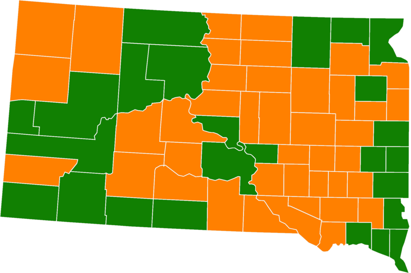
English: Results of South Dakota Amendment A (Marijuana Legalization Initiative) by county. Green = Majority Yes votes, Red = Majority No votes |
| Date | |
| Source |
Data: https://electionresults.sd.gov/resultsSW.aspx?type=BQ&map=CTY Original File: https://commons.wikimedia.org/wiki/File:Blank_map_subdivisions_South_Dakota.svg |
| Author | US Census Bureau (Original), Own work (Colors) |
Licensing
| This file is made available under the Creative Commons CC0 1.0 Universal Public Domain Dedication. | |
| The person who associated a work with this deed has dedicated the work to the public domain by waiving all of their rights to the work worldwide under copyright law, including all related and neighboring rights, to the extent allowed by law. You can copy, modify, distribute and perform the work, even for commercial purposes, all without asking permission.
|
File history
Click on a date/time to view the file as it appeared at that time.
| Date/Time | Thumbnail | Dimensions | User | Comment | |
|---|---|---|---|---|---|
| current | 19:32, 24 February 2021 | | 2,000 × 1,328 (178 KB) | TheNavigatrr | Made this file visible to people with red-green colorblindness. |
| 00:35, 26 December 2020 |  | 2,000 × 1,328 (213 KB) | PDMagazineCoverUploading | Less bright green | |
| 02:56, 5 December 2020 |  | 2,000 × 1,328 (212 KB) | PDMagazineCoverUploading | Uploaded a work by US Census Bureau (Original), Own work (Colors) from Data: https://electionresults.sd.gov/resultsSW.aspx?type=BQ&map=CTY Original File: https://commons.wikimedia.org/wiki/File:Blank_map_subdivisions_South_Dakota.svg with UploadWizard |
File usage
No pages on the English Wikipedia use this file (pages on other projects are not listed).