Charlotte, Vermont | |
|---|---|
 Charlotte town hall | |
 Location in Chittenden County and the state of Vermont. | |
 Charlotte, Vermont Location in the United States | |
| Coordinates: 44°18′38″N 73°14′59″W / 44.31056°N 73.24972°W | |
| Country | United States |
| State | Vermont |
| County | Chittenden |
| Communities | Cedar Beach East Charlotte Prindle Corners West Charlotte |
| Area | |
| • Total | 50.3 sq mi (130.4 km2) |
| • Land | 41.3 sq mi (106.9 km2) |
| • Water | 9.1 sq mi (23.6 km2) |
| Elevation | 354 ft (108 m) |
| Population (2020) | |
| • Total | 3,912 |
| • Density | 95/sq mi (36.6/km2) |
| Time zone | UTC-5 (Eastern (EST)) |
| • Summer (DST) | UTC-4 (EDT) |
| ZIP code | 05445 |
| Area code | 802 |
| FIPS code | 50-13300[1] |
| GNIS feature ID | 1462068[2] |
| Website | www |
Charlotte /ʃɑːrˈlɒt/ is a town in Chittenden County, Vermont, United States. The town was named for Queen Charlotte, though unlike Charlotte, North Carolina, Charlottesville, Virginia, and other cities and towns that bear her name, the town's name is pronounced with the accent on the second syllable. The population of the town was 3,912 at the 2020 census.[3]
Geography[edit]
Charlotte is located in the southwestern corner of Chittenden County. It is bordered to the north by the town of Shelburne, to the east by Hinesburg, to the southeast by Monkton in Addison County, and to the south by Ferrisburgh in Addison County. To the west the town extends to the New York/Vermont border in the middle of Lake Champlain. According to the United States Census Bureau, the town has a total area of 50.3 square miles (130.4 km2), of which 41.3 square miles (106.9 km2) is land and 9.1 square miles (23.6 km2), or 18.08%, is water.[4] The village of East Charlotte is in the eastern part of the town, while West Charlotte colloquially known as "the West Village" (or the Four Corners Historic District),[5] is located on the west side of U.S. Route 7 in the western part of town.
Charlotte is home to 990-foot-high (300 m) Mount Philo. The park was established in 1924 and is open seasonally.
Demographics[edit]

| Census | Pop. | Note | %± |
|---|---|---|---|
| 1790 | 635 | — | |
| 1800 | 1,231 | 93.9% | |
| 1810 | 1,679 | 36.4% | |
| 1820 | 1,526 | −9.1% | |
| 1830 | 1,702 | 11.5% | |
| 1840 | 1,620 | −4.8% | |
| 1850 | 1,634 | 0.9% | |
| 1860 | 1,589 | −2.8% | |
| 1870 | 1,430 | −10.0% | |
| 1880 | 1,342 | −6.2% | |
| 1890 | 1,240 | −7.6% | |
| 1900 | 1,254 | 1.1% | |
| 1910 | 1,163 | −7.3% | |
| 1920 | 1,160 | −0.3% | |
| 1930 | 1,089 | −6.1% | |
| 1940 | 1,082 | −0.6% | |
| 1950 | 1,215 | 12.3% | |
| 1960 | 1,271 | 4.6% | |
| 1970 | 1,802 | 41.8% | |
| 1980 | 2,561 | 42.1% | |
| 1990 | 3,148 | 22.9% | |
| 2000 | 3,569 | 13.4% | |
| 2010 | 3,754 | 5.2% | |
| 2020 | 3,912 | 4.2% | |
| U.S. Decennial Census[7] | |||
As of the census[1] of 2000, there were 3,569 people, 1,287 households, and 990 families residing in the town. The population density was 86.0 people per square mile (33.2/km2). There were 1,500 housing units at an average density of 36.2 per square mile (14.0/km2). The racial makeup of the town was 97.93% White, 0.20% African American, 0.06% Native American, 0.59% Asian, 0.45% from other races, and 0.78% from two or more races. Hispanic or Latino of any race were 0.70% of the population.
There were 1,287 households, out of which 42.6% had children under the age of 18 living with them, 66.7% were married couples living together, 6.9% had a female householder with no husband present, and 23.0% were non-families. 15.7% of all households were made up of individuals, and 4.3% had someone living alone who was 65 years of age or older. The average household size was 2.77 and the average family size was 3.12.
In the town, the population was spread out, with 29.7% under the age of 18, 4.4% from 18 to 24, 28.1% from 25 to 44, 30.1% from 45 to 64, and 7.7% who were 65 years of age or older. The median age was 39 years. For every 100 females, there were 97.6 males. For every 100 females age 18 and over, there were 93.7 males.
The median income for a household in the town was $62,313, and the median income for a family was $71,090. Males had a median income of $52,470 versus $35,156 for females. The per capita income for the town was $33,942. About 4.5% of families and 5.0% of the population were below the poverty line, including 7.5% of those under age 18 and 3.6% of those age 65 or over.
Public transportation[edit]
Major highways[edit]
 U.S. Route 7 runs north–south through the town.
 Vermont Route F-5 runs east–west from US Route 7 in West Charlotte to the Charlotte-Essex ferry dock.
Ferry[edit]
Hourly ferry service between Essex, New York and Charlotte is provided by the Lake Champlain Transportation Company. Most years in the past decade, the ferry service has run year-round, with the exception of a few days of winter rough or ice-filled lake surface. A commuter bus, operating morning and evening, stops on US Route 7 at Ferry Road for transport to and from Burlington.
Transit[edit]
Since 2022, Amtrak's Ethan Allen Express train has made a stop at Vergennes, 11 miles to the south.[8]


Media[edit]
The Citizen is a weekly newspaper mailed to all residents of Charlotte and nearby Hinesburg. It was established in 2006 as the Charlotte Citizen but changed its name in 2011 when the publication expanded into Hinesburg. In May 2017, The Citizen was acquired by the owners of the Stowe Reporter,[9] who then created the Vermont Community Newspaper Group in 2019.[10]
The Charlotte News is a bi-weekly newspaper delivered every other Thursday to all Charlotte residences. Established in 1958, the Charlotte News is an independent, nonprofit organization.[11] The newspaper is also supported by the Friends of the Charlotte News, a 501(c)(3) nonprofit seeking to support local journalism.[12]
Gallery[edit]
-
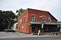 The "Old Brick Store" in the West Village.
 -
 Charlotte Congregational Church in the Charlotte Center Historic District.
 -
 Charlotte Memorial Museum (formerly known as the Town Meeting House), which currently houses the Charlotte Historical Society.
 -
 View of Camel's Hump Mountain from East Charlotte.
 -
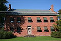
![School house on Greenbush Road, originally built in 1881 and formerly known as the Lakeview Seminary where John Dewey served as its first principal.[5]](https://upload.wikimedia.org/wikipedia/commons/thumb/c/c2/Dewey_School.jpg/90px-Dewey_School.jpg) School house on Greenbush Road, originally built in 1881 and formerly known as the Lakeview Seminary where John Dewey served as its first principal.[5]
School house on Greenbush Road, originally built in 1881 and formerly known as the Lakeview Seminary where John Dewey served as its first principal.[5] -
 The 1812 Tavern on Church Hill Road.


![School house on Greenbush Road, originally built in 1881 and formerly known as the Lakeview Seminary where John Dewey served as its first principal.[5]](https://thcscience.wiki/legality-of-cannabis-by-u-s-jurisdiction/?rdp_we_resource=https%3A%2F%2Fen.wikipedia.org%2Fwiki%2FFile%3ADewey_School.jpg)

Notable people[edit]
- Jamie Aube, racing driver
- Hezekiah Barnes, major general
- John Dewey, American psychologist and educator
- Wilfred Grenfell, medical humanitarian
- Jeffrey Hollender, American businessperson
- Melvin Kaplan, oboist and concert organizer
- Dan Kiley, landscape architect
- Abel E. Leavenworth, educator and soldier
- Cyrus Pringle, botanist
See also[edit]
References[edit]
- ^ a b "U.S. Census website". United States Census Bureau. Retrieved January 31, 2008.
- ^ "US Board on Geographic Names". United States Geological Survey. October 25, 2007. Retrieved January 31, 2008.
- ^ "Census - Geography Profile: Charlotte town, Chittenden County, Vermont". United States Census Bureau. Retrieved December 29, 2021.
- ^ "Geographic Identifiers: 2010 Census Summary File 1 (G001): Charlotte town, Chittenden County, Vermont". U.S. Census Bureau, American Factfinder. Archived from the original on February 13, 2020. Retrieved August 18, 2015.
- ^ a b Cramer, Adele (April 9, 1980). "State Register of Historic Places" (PDF). Vermont Agency of Commerce and Community Development – Division for Historic Preservation.
- ^ Chittenden County Regional Planning Commission (2016). Zoning Map Charlotte Vermont (pdf) (Map) (Updated 2018 ed.). 1:14,400. Town of Charlotte, Vermont.
- ^ "U.S. Decennial Census". United States Census Bureau. Retrieved May 16, 2015.
- ^ "Amtrak, the Vermont Agency of Transportation, and the New York State Department of Transportation Announce Ticket Sales for the Newly Expanded Ethan Allen Express Service in Burlington, Vergennes, and Middlebury". Amtrak. Amtrak Media Center. Retrieved March 29, 2024.
- ^ Walters, John (May 31, 2017). "Media Note: Stowe Reporter Owners Buy Shelburne, Charlotte Newspapers". Seven Days VT. Retrieved April 8, 2020.
- ^ "Newspaper group has new name, six weekly papers". Stowe Today. January 24, 2019. Retrieved April 8, 2020.
- ^ "The Charlotte News is a nonprofit community-based newspaper". The Charlotte News. Retrieved February 24, 2021.
- ^ "Donate to The Charlotte News". Friends of the Charlotte News. Retrieved February 24, 2021.
External links[edit]
Municipalities and communities of Chittenden County, Vermont, United States | ||
|---|---|---|
| Cities | ||
| Towns | ||
| Villages | ||
| CDPs | ||
| Unincorporated communities | ||
| International | |
|---|---|
| National | |
| Geographic | |