| Pyhä-Luosto National Park | |
|---|---|
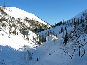
 Isokuru in March 2006 | |
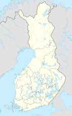
| Location | Lapland, Finland |
| Coordinates | 67°03′59″N 26°58′25″E / 67.06639°N 26.97361°E |
| Area | 142 km2 (55 sq mi) |
| Established | 2005 |
| Visitors | 128000 (in 2009[1]) |
| Governing body | Metsähallitus |
| Website | www |
Pyhä-Luosto National Park (Pyhä-Luoston kansallispuisto) is a national park in Lapland, Finland. It was established in 2005 when Finland's oldest national park, Pyhätunturi National Park (established in 1938), was joined to Luosto. This makes Pyhä-Luosto both one of Finland's oldest and newest national parks. The park covers 142 square kilometres (55 sq mi).[2] Its most important features are its geological specialities, old forests and wetlands.
The park's base is formed by Finland's southernmost, 12-peak tunturi line. The tunturit are remnants of 2-billion-year-old Alp-like mountains. Pine tree forests that are 200 years old or older grow on the hills. The highest tunturit are Noitatunturi, 540 m (1,772 ft), and Ukko-Luosto, 514 m (1,686 ft).
In 2015, the visitor count was 115,100 people, which was a decrease from the 2009 count of 128,000.[2][1]
See also[edit]
References[edit]
- ^ a b "Käyntimäärät kansallispuistoittain 2009" (in Finnish). Metsähallitus. Retrieved September 29, 2010.
- ^ a b Riikka Puhakka; Kati Pitkanen; Pirkko Siikamaki (2020). "The health and well-being impacts of protected areas in Finland". In Hubert Job; Susanne Becken; Bernard Lane (eds.). Protected Areas, Sustainable Tourism and Neo-liberal Governance Policies: Issues, Management and Research. Routledge. p. 138. ISBN 9780429856310. Retrieved 4 November 2022.
External links[edit]
 Media related to Pyhä-Luosto National Park at Wikimedia Commons
- Outdoors.fi – Pyhä-Luosto National Park
