Tovuz District | |
|---|---|
 Map of Azerbaijan showing Tovuz District | |
| Country | |
| Region | Gazakh-Tovuz |
| Established | 8 August 1930 |
| Capital | Tovuz |
| Settlements[1] | 104 |
| Government | |
| • Governor | Mammad Mammadov |
| Area | |
| • Total | 1,940 km2 (750 sq mi) |
| Population | |
| • Total | 177,200 |
| • Density | 91/km2 (240/sq mi) |
| Time zone | UTC+4 (AZT) |
| Postal code | 6000 |
| Website | tovuz-ih |

Tovuz District (Azerbaijani: Tovuz rayonu) is one of the 66 districts of Azerbaijan. It is located in the north-west of the country and belongs to the Gazakh-Tovuz Economic Region. The district borders the districts of Gadabay, Shamkir, Samukh, Agstafa, as well as the Tavush Province of Armenia and Kakheti region of Georgia. Its capital and largest city is Tovuz. As of 2020, the district had a population of 177,200.[2] A major train line runs through the center, stopping at Tovuz Station.
In July 2020, Tovuz became the main site for the clashes with Armenia.[3]
Geography[edit]
Tovuz covers 412 km2. The rayon is mountainous in the south, where it is crossed by the Lesser Caucasus mountains.[4]
The region includes rich deposits of ores and precious metals, notably gold.[5]
The region is located in the north-west of the Republic, bordering Georgia to the north, Armenia to the west, Gadabay to the south and south-west, Shamkir to the east, Samukh from north-east to the north.[6]
The southern part of the district is located in the lowlands, the northern part lies in low mountainous and foothill zone, where positive and negative relief forms are shifted. There are three climate areas in the district:[6]
- Dry subtropical climate. Characterized by soft summers and hot springs.
- Mild hot dry climate. This is a climate up to place less than 1000 meters high. The winter is mild and the spring is warmer.
- Mild cold, forest climate. This climatic hill covers the area from 1,000 to 2,000 meters. The spring is cool, and the winter is a bit frosty.
The river network:[6]
- the Kur River in the north
- the Tovuz River in the central part
- the Akhunca River,
- the Asrik River,
- the Zayam River in the eastern part and its small arms,
The Kur River divides the region into two parts. The left coast is used as the main pasture for cattle breeding. The right bank of the river is used for agriculture, occupies the forest fund of the region and the meadow grassland. The annual rainfall is 40–70 mm.[6]
Villages[edit]
There about 20 main villages in the district. They are Quşçu, Öysüzlü, Ayıblı, Alakol, Yuxarı Öysüzlü, Abulbəyli, Düz Qırıqlı, Düz Cırdaxan, Yanıqlı, Qəribli, Azaplı, Bozalqanlı, Dönük Qırıqlı, İbrahimhacılı, Dondar Quşçu, Kirən, Əlibəyli villages and Qovlar settlement. Qovlar settlement is more populated area among them.[7]
Population[edit]
According to the statistics urbanization is low in the district. 26968 people live in the city and 130907 people live in the village. According to census of 2019, Tovuz has over 175.5 thousand people, out of which 1531 are war veterans.
Over 25536 are students and currently are in process of education.[8]
According to census of 2012 quantity of people from different nations were divided in this way:[9]
| Tovuz District | 157875 |
| Azerbaijanis | 157599 |
| Turkish | 157 |
| Russians | 76 |
| Talysh | 6 |
| Таtars | 4 |
| Armenians | 4 |
| Other nations | 21 |
Cultural centers[edit]
In Tovuz district, there are 4 museums, 13 cultural centers, 6 libraries and a Photo Gallery.Mədəniyyət - TOVUZ RAYON Icra Hakimiyyəti. Museums include Heydar Aliyev Center, History and Local Lore Museum, Ozan Ashug Museum and State Symbols Museum.[10][11]
Archaeology[edit]
The ancient village of Goytepe (Göy Tepe) is one of the largest archaeological monuments in Tovuz District, and in Ganja – Gazakh region. It is located 2 km to the northeast from the village of Aşağı Quşçu, and well south of the current course of Kura river, but closer to Tovuz river which is flowing into Kura.
Starting in 2008, “Tovuz Archaeological expedition” conducted new archaeological investigations at Goytepe, and also at the Mentesh tepe ancient settlement nearby. This is a joint investigation of archaeologists from Azerbaijan, Japan and France.
In this same area of Azerbaijan are also located the ancient sites of Shomu Tepe, Soyuq Bulaq, and Boyuk Kesik. Shulaveris Gora is just across the border in Georgia.
Mentesh tepe[edit]
Mentesh tepe is located close to Zeyem river about 10km east of Goytepe.[12] The excavations of Neolithic levels at Mentesh Tepe have brought to light a material culture related to the Shulaveri-Shomu culture, with some similarity to Baba-Dervish site. The earliest levels of Mentesh represent an advanced Neolitic culture with full domestication of cereals and animals. The pottery is also found, although in small numbers.
The occupation at Mentesh continued for a long period to the end of the Early Bronze Age. Local metallurgy here started already in the first half of the 6th millennium, and developed further during the second half of the 5th millennium.[13]
Economy[edit]
The region is dominated by agriculture. Wine, fruit, vegetables and grain crops are all produced along with cattle.[4]
Stock raising is one of the main revenue source of this region:[9]
| Year | 2006 | 2007 | 2008 | 2009 | 2010 | 2011 |
| The number of cattle | 38280 | 39993 | 40813 | 41558 | 41741 | 42275 |
| Number of cows and buffalos | 16185 | 16987 | 17330 | 17416 | 17420 | 17587 |
| Number of sheep and goat | 183429 | 192050 | 193543 | 195542 | 195749 | 196362 |
| Birds | 340033 | 347605 | 375607 | 385025 | 409252 | |
| Pigs | 200 | 210 | 215 | - | - | - |
| horses | 659 | 664 | 724 | 804 | 774 | |
| Donkeys | 3049 | 3051 | 3052 | 2986 | 2795 | |
| Meat(tons) | 23424 | 24852 | 25532 | 25839 | 27350 | 28225 |
| Eggs | 14628 | 14970 | 15140 | 15310 | 15840 | 16015 |
| Wool production(tons) | 295 | 331 | 340 | 344 | 351 | 358 |
There are 24 entities which operate in industrial and agricultural sphere:[9]
| Year | 2006 | 2007 | 2008 | 2009 | 2010 |
| Bread | 1844 | 1626 | 1840 | 2156 | 2686 |
| Building sand(,000 tons) | 5 | 6.7 | 7.8 | 13.4 | 5.9 |
| Flour(tons) | 1536 | 1504 | 1306 | 888 | 483 |
| Wheat bran(tons) | 497.6 | 349.4 | 190.7 | 148.7 | 131.6 |
| Wheat groats(tons) | 72.5 | 32.9 | 31.0 | 15.0 | 100 |
| Wine(,000 dal) | 17.1 | 26.2 | 17.0 | 13.7 | 25.3 |
| Fruit alcohol(,000 dal) | 63.0 | 36.3 | - | - | - |
| Cognac, thousand dal | 6.7 | 36.4 | 11.1 | 10.3 | 9.1 |
| Refined sugar,tons | 140.0 | 155.7 | 70.0 | 28.0 | -- |
| Asphalt, bituminous mixtures. | 0.4 | -- | 1.4 | -- | -- |
Where the sown areas for agricultural plants are:[9]
| Year | 2005 | 2007 | 2008 | 2009 | 2010 | 2011 |
| Tovuz District | 27 182 | 26 868 | 26 927 | 26 827 | 22 659 | 21 839 |
2020 Tovuz clashes[edit]
According to Azerbaijani MOD, in the afternoon of July 12, Armenian Armed Forces started to fire on Azerbaijani State Border Service positions in Tovuz region using artillery mounds.[14] Thus, clashes between the Armenian Armed Forces and Azerbaijani Armed Forces broke out on July 12.The skirmishes resumed on 13 July and are ongoing with varying intensity, having resulted in at least 16 military and one civilian casualties. Among Azerbaijani military casualties were one major general (Polad Hashimov), one colonel (Ilgar Mirzayev) and two majors (Anar Novruzov and Namig Ahmadov).[15] However, the fighting has decreased, the situation in the region is still considered as volatile.[16]
Notable natives[edit]
- Ganira Pashayeva, Member (MP) of the National Assembly of Azerbaijan for Tovuz District and journalist
Gallery[edit]
-
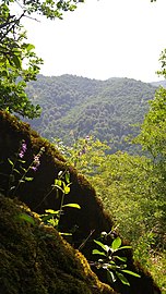 Nature in Tovuz District
 -
 Museum of History in Tovuz
 -
 Park in Tovuz


References[edit]
- ^ "İnzibati-ərazi vahidləri" (PDF). preslib.az. Retrieved 28 February 2021.
- ^ a b "Population of Azerbaijan". stat.gov.az. State Statistics Committee. Retrieved 22 February 2021.
- ^ Harutyunyan, Sargis; Danielyan, Emil. "Armenia-Azerbaijan Border 'Calm' After Deadly Clashes". azatutyun.am. RFE/RL. Archived from the original on 5 August 2020. Retrieved 5 August 2020.
...the border between Armenia's northern Tavush province and the Tovuz district in Azerbaijan, the scene of the clashes.
- ^ a b Azerbaijan Development Gateway concerning both the District and the town Archived November 14, 2008, at the Wayback Machine
- ^ azerb.com concerning both the District and the town (in German)
- ^ a b c d "Coğrafi mövqeyi - TOVUZ RAYON Icra Hakimiyyəti". tovuz-ih.gov.az. Retrieved 2019-05-30.
- ^ Samadov (www.anarsamadov.net), Anar. "Azərbaycanın regionları". Azərbaycan Respublikasının Dövlət Statistika Komitəsi (in Azerbaijani). Retrieved 2019-06-29.
- ^ "Əhalisi - TOVUZ RAYON Icra Hakimiyyəti". tovuz-ih.gov.az. Retrieved 2019-05-30.
- ^ a b c d "Динамика местных тенденций изменения климата, природных катастроф и анализ экологических, социально-экономических последствий в трансграничном целевом ареале реки Кура" (PDF). 2012.[permanent dead link]
- ^ "Ilham Aliyev opened Museum of History and Local Lore in Tovuz district". Official web-site of President of Azerbaijan. Retrieved 2020-03-06.
- ^ "Ilham Aliyev inaugurated State Symbols Museum in Tovuz". Official web-site of President of Azerbaijan. Retrieved 2020-03-06.
- ^ location map of Mentesh tepe close to Zeyem river
- ^ Antoine Courcier et al (2016), The ancient metallurgy in Azerbaijan from the end of the Neolithic to the Early Bronze Age (6th-3rd millennium BCE): an overview in the light of new discoveries and recent archaeometallurgical research.
- ^ "The units of the armed forces of Armenia committed a provocation in the Tovuz direction of the front". mod.gov.az. Retrieved 2020-08-02.
- ^ "Fierce fighting in the direction of Tovuz region is continuing". 2020-07-14. Archived from the original on 2020-07-14. Retrieved 2020-08-02.
- ^ Stronski, Paul. "Behind the Flare-Up Along Armenia-Azerbaijan Border". Carnegie Endowment for International Peace. Retrieved 2020-08-02.
External links[edit]
- Tovuz, the land of antiquity and natural beauty. washingtontimes.com
40°59′32″N 45°37′44″E / 40.9922°N 45.6289°E
| International | |
|---|---|
| National | |
| Geographic | |