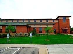
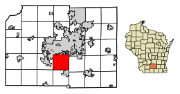
Fitchburg, Wisconsin | |
|---|---|
 Fitchburg City Hall | |
 Location of Fitchburg in Dane County, Wisconsin. | |
| Coordinates: 43°0′23″N 89°25′53″W / 43.00639°N 89.43139°W | |
| Country | |
| State | |
| County | Dane |
| Government | |
| • Type | Mayor-council[1] |
| • Mayor | Julia Arata-Fratta[2] |
| Area | |
| • Total | 35.16 sq mi (91.06 km2) |
| • Land | 34.92 sq mi (90.44 km2) |
| • Water | 0.24 sq mi (0.62 km2) |
| Population | |
| • Total | 29,609 |
| • Density | 881.79/sq mi (340.46/km2) |
| Time zone | UTC−6 (Central (CST)) |
| • Summer (DST) | UTC−5 (CDT) |
| Zipcode | 53711, 53719 |
| Area code | 608 |
| FIPS code | 55-25950[5] |
| Website | fitchburgwi |
Fitchburg is a city in Dane County, Wisconsin, United States. The population was 29,609 at the 2020 census. Fitchburg is a suburb of Madison and is part of the Madison Metropolitan Statistical Area. Fitchburg consists of a mix of suburban neighborhoods closer to the border with the city of Madison, commercial and industrial properties, and more rural properties in the southern portion of the city.
History[edit]
Fitchburg was a town until its incorporation as a city on April 26, 1983. Dutch immigrant brothers Vroman are claimed to be the first permanent settlers of Greenfield, then changed to Fitchburg to avoid confusion with Greenfield, Milwaukee county. A significant number of Irish families settled in Fitchburg as well. As the city of Madison began to encroach upon the town of Fitchburg via annexation, the town pursued incorporation as a city to halt Madison's expansion into the town. The fight to allow incorporation ultimately went to the Wisconsin State Supreme Court, which ruled that Fitchburg could incorporate as a city.[7][8]
Former unincorporated communities[edit]
Geography[edit]
According to the United States Census Bureau, the city has a total area of 35.21 square miles (91.19 km2), of which, 34.97 square miles (90.57 km2) is land and 0.24 square miles (0.62 km2) is water.[9]
Climate[edit]
| ||||||||||||||||||||||||||||||||||||||||||||||||||||||||||||||||||||||||||||||||||||||||||||||||||||||||||||||||||||||||||||
Demographics[edit]
| Census | Pop. | Note | %± |
|---|---|---|---|
| 1990 | 15,648 | — | |
| 2000 | 20,501 | 31.0% | |
| 2010 | 25,260 | 23.2% | |
| 2020 | 29,609 | 17.2% | |
| U.S. Decennial Census[11] | |||
As of 2021,[13] the median income for a household in the city was $78,218, and the median income for a family was $105,506. Among earners age 16 and up, males had a median income of $52,563 versus $43,133 for females. The per capita income for the city was $50,001. About 8.6% of families and 10.4% of the population were below the poverty line, including 15.8% of those under age 18 and 2.1% of those age 65 or over.
2010 census[edit]
As of the census[4] of 2010, there were 25,260 people, 9,955 households, and 6,238 families living in the city. The population density was 722.3 inhabitants per square mile (278.9/km2). There were 10,668 housing units at an average density of 305.1 per square mile (117.8/km2). The racial makeup of the city was 72.2% White, 10.4% African American, 0.4% Native American, 4.9% Asian, 8.8% from other races, and 3.2% from two or more races. Hispanic or Latino of any race were 17.2% of the population.
There were 9,955 households, of which 33.6% had children under the age of 18 living with them, 47.4% were married couples living together, 10.5% had a female householder with no husband present, 4.7% had a male householder with no wife present, and 37.3% were non-families. 27.3% of all households were made up of individuals, and 5.4% had someone living alone who was 65 years of age or older. The average household size was 2.45 and the average family size was 3.03.
The median age in the city was 32.9 years. 24.5% of residents were under the age of 18; 9.4% were between the ages of 18 and 24; 33.1% were from 25 to 44; 25.3% were from 45 to 64; and 7.6% were 65 years of age or older. The gender makeup of the city was 51.6% male and 48.4% female.
Government[edit]

Julia Arata-Fratta is the Mayor of Fitchburg, first elected to a three year term in 2023. Fitchburg is represented by Mark Pocan (D) in the United States House of Representatives, and by Ron Johnson (R) and Tammy Baldwin (D) in the United States Senate. Melissa Agard (D) and Dianne Hesselbein (D) represent Fitchburg in the Wisconsin State Senate, and Jimmy Anderson (D) and Mike Bare (D) represent Fitchburg in the Wisconsin State Assembly.
City services[edit]
Fitchburg is served by the Fitchburg Police Department and Fitchburg Fire Department. Emergency medical services are provided by the Fitch-Rona EMS district, which also serves the neighboring city and town of Verona. Various portions of Fitchburg are served by municipal sewer, water and natural gas utilities.
Transportation[edit]
Major highways[edit]
Railroads[edit]
The Illinois Central Railroad (now the Badger State Trail) went through the old village. Two Chicago and North Western lines also went through the township. All three lines have since been abandoned and removed except for one CNW line. The CNW line is now operated by Wisconsin and Southern.
Public Transit[edit]
Fitchburg is served by Metro Transit. The B route serves the High Ridge Trail area with service to Downtown Madison towards Northport. Route D2 serves the west side of the city with service to Downtown Madison and the Dane County Regional Airport. Route G serves the Southdale neighborhood with connections to the South Transfer Point and the East Side of Madison. Route 65 provides peak hour commuter service from Downtown Madison and the UW Campus to Terravessa and Fitchburg Center neighborhoods. Route 75 provies peak hour commuter service linking Fitchburg to the Capital Square to the east, Verona and the Epic campus to the west. Fitchburg will be served by the future Metro Bus Rapid Transit system along the "north-south" route, stations are planned for Greenway Crossing, Post Rd, Cahill Main and the south terminus at McKee Road, this service is expected to start by 2027.[16][17]
Trails[edit]
The Badger State Trail, Ice Age Trail, Cannonball trail and SouthWest commuter trail pass through the city, Fitchburg is linked to the Madison area's extensive bike path network.
Airports[edit]
Fitchburg is served by commercial airlines at Dane County Regional Airport in neighboring Madison.
Notable people[edit]
- Jimmy P. Anderson, Wisconsin State Assembly, lives in Fitchburg[18]
- Ada Deer, Native American advocate, scholar, former Assistant Secretary of the Interior, lives in Fitchburg[19]
- Frances Huntley-Cooper, Former Mayor, lives in Fitchburg[20]
- Elizabeth McCoy (microbiologist), Microbiologist and Professor, lived in Fitchburg[21]
- Mahlon Mitchell, President of the Professional Firefighters of Wisconsin and 2018 Democratic candidate for Governor, lives in Fitchburg[22]
- Roscoe Mitchell, Saxophonist and composer, lives in Fitchburg[23]
- Homer A. Stone, Wisconsin State Assembly and farmer, was born in Fitchburg[24]
References[edit]
- ^ "Its corporate authority is vested in a mayor and common council comprised of the mayor and eight alderpersons, two from each of four aldermanic districts." Code of Ordinances, Article I, Sec. 4.1
- ^ "Mayor". The City of Fitchburg. Retrieved June 1, 2023.
- ^ "2019 U.S. Gazetteer Files". United States Census Bureau. Retrieved August 7, 2020.
- ^ a b "U.S. Census website". United States Census Bureau. Retrieved November 18, 2012.
- ^ "U.S. Census website". United States Census Bureau. Retrieved January 31, 2008.
- ^ "US Board on Geographic Names". United States Geological Survey. October 25, 2007. Retrieved January 31, 2008.
- ^ "About Fitchburg". Fitchburg city website. Archived from the original on June 2, 2008. Retrieved April 2, 2009.
- ^ Connie Darling and Jean A. O'Brien (1976). Fitchburg: A History. Countryside Publications.
- ^ "US Gazetteer files 2010". United States Census Bureau. Archived from the original on January 12, 2012. Retrieved November 18, 2012.
- ^ "NASA Earth Observations Data Set Index". NASA. Archived from the original on August 6, 2013. Retrieved January 30, 2016.
- ^ "Census of Population and Housing". Census.gov. Retrieved June 4, 2015.
- ^ "City and Town Population Totals: 2010-2020". Retrieved June 22, 2021.
- ^ "U.S. Census Data Tables". Retrieved November 17, 2023.
- ^ DNR website
- ^ Hatcheries page
- ^ https://www.cityofmadison.com/metro/documents/brt/North-South%20Bus%20Rapid%20Transit.pdf [bare URL PDF]
- ^ https://www.cityofmadison.com/metro/documents/system-maps/System_Map_Dec23_en.pdf [bare URL PDF]
- ^ "Representative Jimmy Anderson". docs.legis.wisconsin.gov. Retrieved December 4, 2019.
- ^ Deer, Ada (November 27, 2019). "The Fight for Menominee Rights". A Public Affair (Interview). Interviewed by Ali Maldra. Madison, WI: WORT. Retrieved March 19, 2021.
- ^ Rinard, Amy. "State's First Black Mayor A Media Celebrity". No. April 6, 1991. Milwaukee Sentinel. Sentinel Madison Bureau.[permanent dead link]
- ^ "UW Prof. McCoy Dies Friday at 75". Wisconsin State Journal. March 26, 1978. p. 4. Retrieved March 3, 2019 – via Newspapers.com.

- ^ "Candidate Profile: Mahlon Mitchell". TMJ4 News. July 9, 2018. Retrieved March 7, 2024.
- ^ "SFJAZZ.org | NEA Jazz Masters QA Roscoe Mitchell". www.sfjazz.org. Retrieved March 7, 2024.
- ^ 'Wisconsin Blue Book 1917,' Biographical Sketch of Homer A. Stone, pg. 524

