
| Char Dham National Highway | |
|---|---|
| Route information | |
| Maintained by National Highways Authority of India | |
| Length | 889 km (552 mi) |
| Major junctions | |
| North end | Mana |
| South end | Rishikesh |
| Location | |
| Country | India |
| States | Uttarakhand |
| Major cities | Rishikesh, Dharasu, Yamunotri, Gangotri, Rudraprayag, Gaurikund, Kedarnath, Joshimath, Badrinath, Mana[1] |
| Highway system | |
| National Highways | |
Char Dham National Highway, is an under construction two-lane (in each direction) 889 km long National Highway with a minimum width of 10 metres in the Indian state of Uttarakhand under Char Dham Pariyojana. The under construction highway will complement the under-construction Char Dham Railway by connecting the four holy places in Uttarakhand states namely Badrinath, Kedarnath, Gangotri and Yamunotri. The project includes 889 km national highways which will connect the whole of Uttarakhand state.[2][3] It will connect Delhi–Dehradun Expressway on its southern end to India-China Border Roads on its northern ends.
Development[edit]
The total cost of ₹12,000 crores and the foundation stone of the project was laid by Prime Minister Narendra Modi on 27 December 2016 at Parade Ground in Dehradun. The highway will be called Char Dham Mahamarg (Char Dham Highway) and the highway construction project will be called as Char Dham Mahamarg Vikas Pariyojana (Char Dham Highway Development Project) and is made to improve the connectivity to the Chota Char Dham nestled in the Himalayas.[2][3][4][5] Road will include several long bridges and tunnels to eliminate accident and slide prone areas. Indian Railways and National Highways Authority of India have been directed, by the Cabinet Secretary of India, to ensure that rail and road highway routes are integrated on this circuit.[6]
Route alignment[edit]
Originating from Rishikesh, Char Dham highway network will have 5 distinct routes,[6]
From west to east and south to north:
- Rishikesh–Yamunotri
- Rishikesh–Gangotri (same route as previous one till Dharasu). This will take the railway and Char Dham road highway at Gangotri close to the border area of Nelang Valley .[8][9]
- Rishikesh–Kedarnath
- Rishikesh
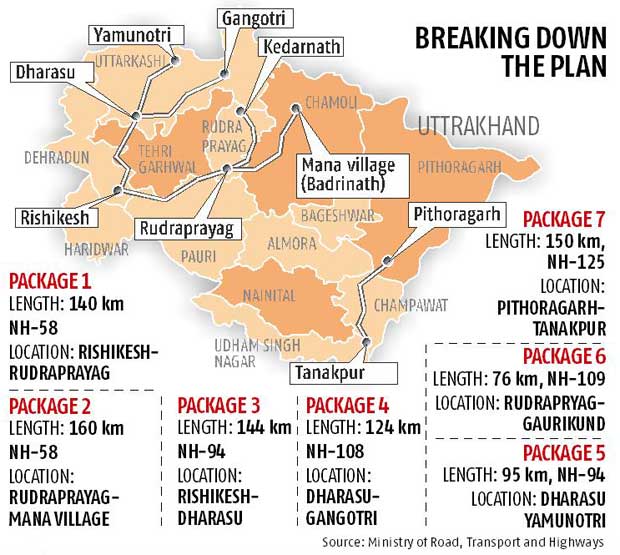
- Rudraprayag, NH 58, 140 km from Rishikesh
- Gaurikund (trek 12.6 km to Kedarnath on foot, by pony or helicopter ride), NH 109, 76 km from Rudraprayag, Road transport goes up to Gaurikund.[7]
- Rishikesh–Badrinath (same route are previous one till Rudraprayag). This will take the railway and Char Dham road highway at Badrinath closer to the area of Barahoti .[9][10]
- Rishikesh
- Rudraprayag, NH 58, 140 km from Rishikesh
- Joshimath
- Mana (trek to Badrinath), NH 58, 140 km from Rudraprayag, motorable all the way to Badrinath, Tapt Kund ‘hot springs’ is just before the Badrinath Temple.[7]
- Pithoragagh-Lipulekh Pass Highway (PLPH), nearly 350 km long route to Lipulekh Pass on India-Tibet border for Kailas-Manasarovar yatra.[11]
- Budi-Garbyang tunnel, 6 km long, Rs2000 cr 2-lane tunnel planned for swifter all-weather Kailash-Mansarovar yatra.[11]
- a spur from Nabidhang runs along a glaciated river to Om Parvat.
- Gunji-Lampiya Dhura Pass Road (GLDPR) runs through Kuti from Gunji, via Adi Kailash, to Lampiya Dhura Pass (Limpiyadhura Pass on India-Tibet border).
Facilities[edit]
The project will have bypasses, bridges, viaducts, pit stops, parking, helipads and helicopter emergency response services, etc. along the way.[12]
Status updates[edit]
- Dec 2016: Prime Minister Narendra Modi laid the foundation stone in December 2016.[12][13]
- July 2023: 75% (601 km out of 825 km) of Char Dham Yatra highways complete.[14]
See also[edit]
References[edit]
- ^ "Work on KMP Expressway to start soon". The Hindu. Retrieved 9 January 2016.
- ^ a b Chardham highway project: PM Modi lays foundation stone in Dehradun
- ^ a b PM to Lay Foundation Stone of ‘Chardham Mahamarg Vikas Pariyojna’
- ^ PM Modi lays foundation stone for 900-km highway network
- ^ Uttarakhand: PM Modi to lay foundation stone of Chardham Mahamarg
- ^ a b Safer, smoother, shorter Char Dham Yatra, Times of India, 3-Sept-2014
- ^ a b c d Char Dham Yatra 2019: How to reach, where to stay and its significance for devotees, financialexpress.com, April 2019.
- ^ 采编 (26 November 2005). "中印边境自卫反击作战史". 中国国防资讯网. Archived from the original on 26 June 2009. Retrieved 26 November 2005.
- ^ a b Achilles Heel in India's Border Defence with China!, Indian Defence Review, 20 June 2017.
- ^ After 24 years of work, strategic military outpost near India-China border connected with motorable road, Times of India, 11 Nov 2016.
- ^ a b Uttarakhand: 6-km tunnel to be built between Bundi, Garbyang on way to India-China border, The Print, 23 May 2023.
- ^ a b "PM Modi lays foundation for Rs 12,000-crore Char Dham highway project, Economic Times, 27-Dec-2016". Archived from the original on 13 August 2017. Retrieved 23 May 2017.
- ^ Centre's 'Chardham' highway project under NGT scanner, Economic Times, 4-May-2017
- ^ 601 km of Char Dham Yatra highways complete., Infra.com, 27 july 2023.


