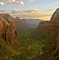
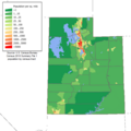
The Utah Portal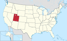  Utah (/ˈjuːtɑː/ YOO-tah, /ˈjuːtɔː/ ⓘ YOO-taw; Navajo: Áshįįh Biiʼtó Hahoodzo) is a landlocked state in the Mountain West subregion of the Western United States. It borders Colorado to its east, Wyoming to its northeast, Idaho to its north, Arizona to its south, and Nevada to its west. Utah also touches a corner of New Mexico in the southeast. Of the fifty U.S. states, Utah is the 13th-largest by area; with a population over three million, it is the 30th-most-populous and 11th-least-densely populated. Urban development is mostly concentrated in two areas: the Wasatch Front in the north-central part of the state, which is home to roughly two-thirds of the population and includes the capital city, Salt Lake City; and Washington County in the southwest, with more than 180,000 residents. Most of the western half of Utah lies in the Great Basin. Utah has been inhabited for thousands of years by various indigenous groups such as the ancient Puebloans, Navajo, and Ute. The Spanish were the first Europeans to arrive in the mid-16th century, though the region's difficult geography and harsh climate made it a peripheral part of New Spain and later Mexico. Even while it was Mexican territory, many of Utah's earliest settlers were American, particularly Mormons fleeing marginalization and persecution from the United States via the Mormon Trail. Following the Mexican–American War in 1848, the region was annexed by the U.S., becoming part of the Utah Territory, which included what is now Colorado and Nevada. Disputes between the dominant Mormon community and the federal government delayed Utah's admission as a state; only after the outlawing of polygamy was it admitted in 1896 as the 45th. People from Utah are known as Utahns. Slightly over half of all Utahns are Mormons, the vast majority of whom are members of the Church of Jesus Christ of Latter-day Saints (LDS Church), which has its world headquarters in Salt Lake City; Utah is the only state where a majority of the population belongs to a single church. A 2023 paper challenged this perception (claiming only 42% of Utahns are Mormons) however most statistics still show a majority of Utah residents belong to the LDS church; estimates from the LDS church suggests 60.68% of Utah's population belongs to the church whilst some sources put the number as high as 68%. The paper replied that membership count done by the LDS Church is too high for several reasons. The LDS Church greatly influences Utahn culture, politics, and daily life, though since the 1990s the state has become more religiously diverse as well as secular. (Full article...) Entries here consist of Good and Featured articles, which meet a core set of high editorial standards.
The Topaz War Relocation Center, also known as the Central Utah Relocation Center (Topaz) and briefly as the Abraham Relocation Center, was an American concentration camp in which Americans of Japanese descent and immigrants who had come to the United States from Japan, called Nikkei were incarcerated. President Franklin Roosevelt signed Executive Order 9066 in February 1942, ordering people of Japanese ancestry to be incarcerated in what were euphemistically called "relocation centers" like Topaz during World War II. Most of the people incarcerated at Topaz came from the Tanforan Assembly Center and previously lived in the San Francisco Bay Area. The camp was opened in September 1942 and closed in October 1945. The camp, approximately 15 miles (24.1 km) west of Delta, Utah, consisted of 19,800 acres (8,012.8 ha), with a 640 acres (259.0 ha) main living area. Most internees lived in the main living area, though some lived off-site as agricultural and industrial laborers. The approximately 9,000 internees and staff made Topaz into the fifth-largest city in Utah at the time. The extreme temperature fluctuations of the arid area combined with uninsulated barracks made conditions very uncomfortable, even after the belated installation of pot-bellied stoves. The camp housed two elementary schools and a high school, a library, and some recreational facilities. Camp life was documented in a newspaper, Topaz Times, and in the literary publication Trek. Internees worked inside and outside the camp, mostly in agricultural labor. Many internees became notable artists. (Full article...)Selected image - West Mitten Butte Monument Valley, view northeastward from Arizona to Utah
April selected anniversaries
Selected biography - Edwin Jacob "Jake" Garn (born October 12, 1932) is an American politician and member of the Republican Party who served as a United States senator representing Utah from 1974 to 1993. Garn became the first sitting member of Congress to fly in space when he flew aboard the Space Shuttle Discovery as a payload specialist during NASA mission STS-51-D (April 12–19, 1985). Prior to his time in Congress, he served as the mayor of Salt Lake City. (Full article...)Selected article -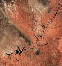 Lake Powell is a reservoir on the Colorado River in Utah and Arizona, United States. It is a major vacation destination visited by approximately two million people every year. It holds 24,322,000 acre-feet (3.0001×10¹⁰ m3) of water when full, second in the United States to only Lake Mead - though Lake Mead has fallen below Lake Powell in size several times during the 21st century in terms of volume of water, depth and surface area. Lake Powell was created by the flooding of Glen Canyon by the Glen Canyon Dam, which also led to the 1972 creation of Glen Canyon National Recreation Area, a popular summer destination of public land managed by the National Park Service. The reservoir is named for John Wesley Powell, a civil war veteran who explored the river via three wooden boats in 1869. It lies primarily in southern Utah, with a small portion in northern Arizona. (Full article...)Did you know -
Selected panorama - Landscape Arch in Arches National Park
TopicsCategoriesGeneral imagesThe following are images from various Utah-related articles on Wikipedia.
State facts
State symbols:
Featured contentArticles:
Lists:
Pictures: Related portals
Lists
Related WikiProjectsNew articlesThis list was generated from these rules. Questions and feedback are always welcome! The search is being run daily with the most recent ~14 days of results. Note: Some articles may not be relevant to this project.
Rules | Match log | Results page (for watching) | Last updated: 2024-04-24 23:16 (UTC) Note: The list display can now be customized by each user. See List display personalization for details.
Things you can doAssociated WikimediaThe following Wikimedia Foundation sister projects provide more on this subject:
Discover Wikipedia using portals |


