[3] Name on the Register
Image
Date listed[4]
Location
City or town
Description
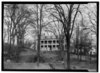
1
Baldwin-Reynolds House Baldwin-Reynolds House December 30, 1974 (#74001777 ) Terrace Street 41°38′52″N 80°09′07″W / 41.647778°N 80.151944°W / 41.647778; -80.151944 (Baldwin-Reynolds House ) Meadville
2
Bentley Hall Bentley Hall May 6, 1977 (#77001156 ) Allegheny College campus41°38′55″N 80°08′51″W / 41.648611°N 80.1475°W / 41.648611; -80.1475 (Bentley Hall ) Meadville
3
Bridge in East Fallowfield Township Bridge in East Fallowfield Township June 22, 1988 (#88000825 ) Legislative Route 20012 over Unger Run 41°32′06″N 80°20′12″W / 41.535000°N 80.336667°W / 41.535000; -80.336667 (Bridge in East Fallowfield Township ) East Fallowfield Township Replaced
4
Bridge in Oil Creek Township Bridge in Oil Creek Township June 22, 1988 (#88000833 ) State Route 2020 over Oil Creek 41°37′45″N 79°42′10″W / 41.629167°N 79.702778°W / 41.629167; -79.702778 (Bridge in Oil Creek Township ) Oil Creek Township Removed from site.[5]
5
Bridge in Rockdale Township Bridge in Rockdale Township June 22, 1988 (#88000829 ) Legislative Route 20076 over French Creek 41°48′38″N 79°59′02″W / 41.810417°N 79.983889°W / 41.810417; -79.983889 (Bridge in Rockdale Township ) Rockdale Township Replaced
6
Bridge in West Mead Township Bridge in West Mead Township June 22, 1988 (#88000827 ) Legislative Route 20027 over French Creek 41°35′21″N 80°09′02″W / 41.589167°N 80.150556°W / 41.589167; -80.150556 (Bridge in West Mead Township ) West Mead Township Replaced
7
John Brown Tannery Site John Brown Tannery Site December 14, 1978 (#78002383 ) 500 feet south of the junction of Pennsylvania Route 77 and John Brown Road[6] 41°43′09″N 79°57′04″W / 41.719167°N 79.951111°W / 41.719167; -79.951111 (John Brown Tannery Site ) Richmond Township Only the foundation remains after a fire in 1907
8
Cambridge Springs Bridge Cambridge Springs Bridge June 22, 1988 (#88000824 ) Legislative Route 84 spur B over French Creek 41°48′23″N 80°03′41″W / 41.806389°N 80.061389°W / 41.806389; -80.061389 (Cambridge Springs Bridge ) Cambridge Springs Replaced
9
William and Elisabeth Edwards House Upload image February 12, 2024 (#100009921 ) 128 Davenport Street 41°49′22″N 79°41′24″W / 41.8227°N 79.6901°W / 41.8227; -79.6901 (William and Elisabeth Edwards House ) Spartansburg
10
Independent Congregational Church Independent Congregational Church March 8, 1978 (#78002381 ) 346 Chestnut Street 41°38′14″N 80°09′01″W / 41.637222°N 80.150278°W / 41.637222; -80.150278 (Independent Congregational Church ) Meadville
11
Amos Kelly House Amos Kelly House July 23, 1980 (#80003477 ) 325 South Main Street 41°48′06″N 80°03′32″W / 41.801667°N 80.058889°W / 41.801667; -80.058889 (Amos Kelly House ) Cambridge Springs
12
Meadville Downtown Historic District Meadville Downtown Historic District October 2, 1984 (#84000023 ) Roughly bounded by Chancery Lane, Mulberry, Walnut and Chestnut Streets 41°38′20″N 80°09′04″W / 41.638889°N 80.151111°W / 41.638889; -80.151111 (Meadville Downtown Historic District ) Meadville
13
Dr. J.R. Mosier Office Dr. J.R. Mosier Office June 13, 1976 (#77001157 ) Terrace Street 41°38′47″N 80°09′08″W / 41.646389°N 80.152222°W / 41.646389; -80.152222 (Dr. J.R. Mosier Office ) Meadville
14
Riverside Hotel Riverside Hotel December 13, 1978 (#78002380 ) 1 Fountain Street 41°48′21″N 80°03′12″W / 41.80575°N 80.053333°W / 41.80575; -80.053333 (Riverside Hotel ) Cambridge Springs Destroyed by fire, May 2nd, 2017
15
Roueche House Roueche House March 4, 1982 (#82003784 ) 762 Park Avenue 41°38′33″N 80°09′04″W / 41.642500°N 80.151111°W / 41.642500; -80.151111 (Roueche House ) Meadville
16
Ruter Hall Ruter Hall September 18, 1978 (#78002382 ) North Main Street on Allegheny College campus 41°38′54″N 80°08′46″W / 41.648333°N 80.146111°W / 41.648333; -80.146111 (Ruter Hall ) Meadville
17
Edward Saeger House Edward Saeger House August 22, 1980 (#80003479 ) 375 Main Street 41°43′07″N 80°08′53″W / 41.718611°N 80.148056°W / 41.718611; -80.148056 (Edward Saeger House ) Saegertown
18
Judge Henry Shippen House Judge Henry Shippen House June 6, 1984 (#84003339 ) 403 Chestnut Street 41°38′14″N 80°08′52″W / 41.637222°N 80.147778°W / 41.637222; -80.147778 (Judge Henry Shippen House ) Meadville
19
Titusville City Hall Titusville City Hall March 31, 1975 (#75001635 ) 107 North Franklin Street 41°37′39″N 79°40′25″W / 41.627417°N 79.673694°W / 41.627417; -79.673694 (Titusville City Hall ) Titusville
20
Titusville Historic District Titusville Historic District January 31, 1985 (#85000178 ) Roughly bounded by Petroleum, Spruce, Franklin, Perry, Monroe, Main and Spring Streets 41°37′47″N 79°40′26″W / 41.629722°N 79.673889°W / 41.629722; -79.673889 (Titusville Historic District ) Titusville