Gölköy | |
|---|---|
District and municipality | |
 | |
 Map showing Gölköy District in Ordu Province | |
 Gölköy Location in Turkey | |
| Coordinates: 40°41′15″N 37°37′04″E / 40.68750°N 37.61778°E | |
| Country | Turkey |
| Province | Ordu |
| Government | |
| • Mayor | Fikri Uludağ (AKP) |
| Area | 421 km2 (163 sq mi) |
| Elevation | 820 m (2,690 ft) |
| Population (2022)[1] | 25,960 |
| • Density | 62/km2 (160/sq mi) |
| Time zone | UTC+3 (TRT) |
| Postal code | 52600 |
| Area code | 0452 |
| Climate | Csb |
| Website | www |
Gölköy is a municipality and district of Ordu Province, Turkey.[2] Its area is 421 km2,[3] and its population is 25,960 (2022).[1] The town is located 60 km (37 mi) inland from the city of Ordu on the road to Sivas. The town lies at an elevation of 820 m (2,690 ft).
Places of interest include the Byzantine castle of Habsamana, and a number of places for walking and climbing including the village of Cihadiye and the lake of Ulugöl.[citation needed]
Composition[edit]
There are 30 neighbourhoods in Gölköy District:[4]
- Ahmetli
- Akçalı
- Alanyurt
- Aydoğan
- Bayıralan
- Bulut
- Çatak
- Çetilli
- Cihadiye
- Damarlı
- Direkli
- Düzyayla
- Emirler
- Gölköy
- Güzelyayla
- Güzelyurt
- Haruniye
- Hürriyet
- İçyaka
- Kaleköy
- Karagöz
- Karahasan
- Konak
- Kozören
- Kuşluvan
- Özlü
- Paşapınar
- Sarıca
- Süleymaniye
- Yuvapınar
Gallery[edit]
-
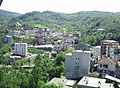 Gölköy town center
 -
 A small lake in Gölköy district
 -
 Gölköy Lake view


References[edit]
- ^ a b "Address-based population registration system (ADNKS) results dated 31 December 2022, Favorite Reports" (XLS). TÜİK. Retrieved 19 September 2023.
- ^ Büyükşehir İlçe Belediyesi, Turkey Civil Administration Departments Inventory. Retrieved 19 September 2023.
- ^ "İl ve İlçe Yüz ölçümleri". General Directorate of Mapping. Retrieved 19 September 2023.
- ^ Mahalle, Turkey Civil Administration Departments Inventory. Retrieved 19 September 2023.
External links[edit]
![]() Media related to Gölköy, Ordu at Wikimedia Commons
Media related to Gölköy, Ordu at Wikimedia Commons
- District governor's official website (in Turkish)
- District municipality's official website (in Turkish)
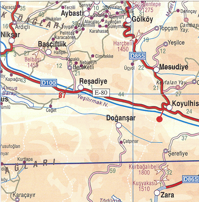
- Road map of Gölköy and environs
- Detailed road map of Gölköy district
- Various images of Gölköy, Ordu

