
Size of this preview: 800 × 533 pixels. Other resolutions: 320 × 213 pixels | 640 × 427 pixels | 1,024 × 683 pixels | 1,280 × 853 pixels | 3,000 × 2,000 pixels.
Original file (3,000 × 2,000 pixels, file size: 1.92 MB, MIME type: image/jpeg)
Summary
| Description |
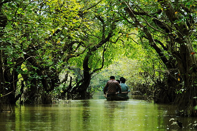
বাংলা: রাতারগুল জলাবন বাংলাদেশের একমাত্র জলাবন বা সোয়াম্প ফরেস্ট এবং বন্যপ্রাণী অভয়ারণ্য। বনের আয়তন ৩,৩২৫.৬১ একর, আর এর মধ্যে ৫০৪ একর বনকে ১৯৭৩ সালে বন্যপ্রাণী অভয়ারণ্য হিসেবে ঘোষণা করা হয়। English: Ratargul Swamp Forest is a freshwater swamp forest located in Gowainghat, Sylhet, Bangladesh. It is the only swamp forest located in Bangladesh and one of the few freshwater swamp forests in the world. The forest is naturally conserved under the Department of Forestry, Govt. of Bangladesh. |
| Date | |
| Source | Own work |
| Author | Sumon Mallick |
| Camera location | | View this and other nearby images on: OpenStreetMap |
|---|
Licensing
I, the copyright holder of this work, hereby publish it under the following license:
This file is licensed under the Creative Commons Attribution-Share Alike 4.0 International license.
- You are free:
- to share – to copy, distribute and transmit the work
- to remix – to adapt the work
- Under the following conditions:
- attribution – You must give appropriate credit, provide a link to the license, and indicate if changes were made. You may do so in any reasonable manner, but not in any way that suggests the licensor endorses you or your use.
- share alike – If you remix, transform, or build upon the material, you must distribute your contributions under the same or compatible license as the original.
This image was uploaded as part of Bangla Wikipedia Photography Contest 2014.
|

|
This image has been assessed under the valued image criteria and is considered the most valued image on Commons within the scope: Category:Ratargul Swamp Forest. You can see its nomination here. |
This image was selected as picture of the day on Bengali Wikipedia.
|
File history
Click on a date/time to view the file as it appeared at that time.
| Date/Time | Thumbnail | Dimensions | User | Comment | |
|---|---|---|---|---|---|
| current | 16:29, 13 October 2014 | | 3,000 × 2,000 (1.92 MB) | Ku.sumon | User created page with UploadWizard |
File usage
The following pages on the English Wikipedia use this file (pages on other projects are not listed):
Global file usage
The following other wikis use this file:
- Usage on bn.wikipedia.org
- সিলেট বিভাগ
- বাংলাদেশের সংরক্ষিত এলাকার তালিকা
- রাতারগুল জলাবন
- উইকিপিডিয়া:আজকের নির্বাচিত ছবি/জানুয়ারি ২০১৬
- টেমপ্লেট:আজকের নির্বাচিত ছবি/২৯ জানুয়ারি ২০১৬
- উইকিপিডিয়া:আজকের নির্বাচিত ছবি/জুন ২০১৬
- টেমপ্লেট:আজকের নির্বাচিত ছবি/১৮ জুন ২০১৬
- উইকিপিডিয়া:বাংলাদেশের সংরক্ষিত জাতীয় উদ্যান
- উইকিপিডিয়া:বাংলাদেশের সংরক্ষিত বন্যপ্রাণী অভয়ারণ্য
- উইকিপিডিয়া:বাংলাদেশের সংরক্ষিত অঞ্চল আপলোড
- উইকিপিডিয়া:বাংলাদেশের সংরক্ষিত অঞ্চলের তালিকা
- উইকিপিডিয়া:বাংলাদেশের অন্যান্য সংরক্ষিত অঞ্চল
- টেমপ্লেট আলোচনা:আপনি জানেন কি/মনোনয়ন সংগ্রহশালা/ব্যর্থ/২০১৮
- প্রবেশদ্বার:সিলেট/ভূমিকা
- প্রবেশদ্বার:সিলেট
- Usage on en.wikivoyage.org
- Usage on ml.wikipedia.org
- Usage on ne.wikipedia.org
- Usage on tr.wikipedia.org
- Usage on zh.wikivoyage.org