
The City Hall in Delft is a Renaissance style building on the Markt across from the Nieuwe Kerk. It is the seat of the city's government as well as a popular venue for civic wedding ceremonies. Most administrative functions have been transferred to an office inside the Delft railway station building. Originally designed by the Dutch architect Hendrick de Keyser, it was heavily changed over the centuries and was restored in the 20th century to its Renaissance appearance.
History[edit]

In the town hall from 1618 are some group portraits, and portraits of the counts of Orange and Nassau, including several by Michiel van Mierevelt (1567–1641), one of the earliest Dutch portrait painters, and with his son Pieter (1595–1623), a native of Delft.[1] The oldest part of the complex is the belfry covered in "Gobertanger" limestone from Wallonia, a building material used often in important renaissance buildings in the Netherlands up to 1600. The tower, called "De Steen" or "The Stone", was originally built around 1300 and has decorative clockfaces from 1536 and the bells were made by Hendrick van Trier and Francois Hemony.[2] The facade has a "Justitia" statue.[2] Under the tower is an old city prison where the assassin of Willem the Silent, Balthasar Gérard, was kept before sentencing.
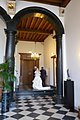
Up the stairway and immediately behind the heavy wooden entrance doors is the Vierschaar, with a decorative painting of the Judgment of Solomon by Pieter van Bronckhorst.
Vierschaar[edit]
-
 Vierschaar with painting on the wall by Bronkhorst
 -
 Judgement of Salomon, by Bronkhorst, 1622
 -
 The City hall is still used for civic weddings, and couples pass through the Vierschaar to the main hall for the ceremony
 -
 Judgement of Salomon by Rubens'workshop, c.1615


Other views[edit]
-
 View of the front facade with sculpture of Justitia
 -
 City hall seen from the tower in the Nieuwe Kerk opposite
 -
 Seen from the front
 -
 Inside, the Nieuwe Kerk is seen through the window
 -
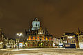 City hall in winter


References[edit]
- ^ One or more of the preceding sentences incorporates text from a publication now in the public domain: Chisholm, Hugh, ed. (1911). "Delft". Encyclopædia Britannica. Vol. 7 (11th ed.). Cambridge University Press. p. 954.
- ^ a b Rijksmonument report