Cheongdo
청도군 | |
|---|---|
| Korean transcription(s) | |
| • Hangul | 청도군 |
| • Hanja | 淸道郡 |
| • Revised Romanization | Cheongdo-gun |
| • McCune-Reischauer | Ch'ŏngdo-gun |
 Cheongdo County is famous for its annual bullfighting festival | |
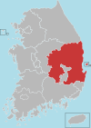
 Location in South Korea | |
| Country | |
| Region | Yeongnam |
| Administrative divisions | 2 eup, 7 myeon |
| Area | |
| • Total | 696.53 km2 (268.93 sq mi) |
| Population (2005) | |
| • Total | 47,099 |
| • Density | 72.8/km2 (189/sq mi) |
| • Dialect | Gyeongsang |

Cheongdo County (Cheongdo-gun) is a county in North Gyeongsang Province, South Korea. It is connected to the national transportation grid by the Gyeongbu Line railroad and the Daegu-Busan Expressway. The seat of government is located in the center of the county, in Hwayang-eup.
In the Samhan period, Cheongdo may have been the site of the small polity of Ieso-guk. It was later absorbed into Silla, and gained its current name of "Cheongdo" in 940. The county's nine subdivisions were established in 1919. The county government moved to its current location in 1961. In 1966, the New Village Movement began in Sindo 1-ri, Cheongdo-eup.
Every year Cheongdo is host to an international bullfighting festival.
The slogan for Cheongdo is "Singgreen Cheongdo."
Administrative divisions[edit]
Cheongdo is divided into two eup and seven myeon, as below. These in turn are divided into 212 ri, and 668 natural villages (jayeon burak).

| Name | Hangeul | Hanja |
|---|---|---|
| Hwayang-eup | 화양읍 | 華陽邑 |
| Cheongdo-eup | 청도읍 | 淸道邑 |
| Gakbuk-myeon | 각북면 | 角北面 |
| Punggak-myeon | 풍각면 | 豊角面 |
| Iseo-myeon | 이서면 | 伊西面 |
| Gangnam-myeon | 각남면 | 角南面 |
| Maejeon-myeon | 매전면 | 梅田面 |
| Geumcheon-myeon | 금천면 | 錦川面 |
| Unmun-myeon | 운문면 | 雲門面 |
Twin towns – sister cities[edit]
Cheongdo is twinned with:
Festivals[edit]
- Bullfighting Festival
- Persimmon (Bansi) Festival
- Lantern Festival
Culture[edit]
Museums[edit]
- Cheongdo Museum
Monuments[edit]
- Cheongdo Memorial Park of Saemaeul Undong
Parks[edit]
- Unmunsan National Recreational Forest
experiences[edit]
- Seonamseowon Confucian Academy
- Cheongdo Hwarang-themed Cultural Park Auto-camping Site
- Cheongdo Bicycle Park Camping Site
- Cheongdo Rail Bike
- Cheongdo Hwarang-themed Cultural Park
- Comedy Cheolgabang Theater
- Korea Comedy Town
Other important spots[edit]
- Cheongdo Bullfighting Stadium
- Cheongdo Wine Tunnel
- Cheongdo Provence
Architecture[edit]
Historical[edit]
- Songamjeongsa House
- Unmunsa Temple
Foreigners[edit]
As Cheongdo is a small town, with a population that is just over 50,000, there is not a high number of foreigners. However, there are a few foreigners that are living there as English teachers through the EPIK Program. Unfortunately, it is very rare to come across a local Cheongdo resident that speaks English. Learning basic Korean is an essential for living in Cheongdo.
Climate & Weather[edit]
Much like the rest of Korea, Cheongdo has four distinct seasons. Summers in Cheongdo can be extremely hot as Cheongdo is only 30 minutes away from Daegu by train. Daegu is known to be one of the hottest cities in South Korea, due to the surrounding mountains that trap all the heat.
Winters can be rather cold, reaching -15 degrees Celsius on occasion. Furthermore, the air is extremely dry during the winter time.
Both Autumn and Spring are rather mild, no extreme weather conditions for either. However, during Spring, typically in April, the air quality is very poor. It is very common to see locals protecting themselves with face masks against the "yellow dust."
| Climate data for Cheongdo (1993–2020 normals) | |||||||||||||
|---|---|---|---|---|---|---|---|---|---|---|---|---|---|
| Month | Jan | Feb | Mar | Apr | May | Jun | Jul | Aug | Sep | Oct | Nov | Dec | Year |
| Mean daily maximum °C (°F) | 6.1 (43.0) |
8.8 (47.8) |
14.3 (57.7) |
20.4 (68.7) |
25.6 (78.1) |
28.4 (83.1) |
30.3 (86.5) |
31.2 (88.2) |
26.8 (80.2) |
21.9 (71.4) |
15.1 (59.2) |
8.0 (46.4) |
19.7 (67.5) |
| Daily mean °C (°F) | −1.1 (30.0) |
1.6 (34.9) |
6.9 (44.4) |
12.9 (55.2) |
18.2 (64.8) |
22.1 (71.8) |
25.5 (77.9) |
25.7 (78.3) |
20.6 (69.1) |
14.1 (57.4) |
7.2 (45.0) |
0.8 (33.4) |
12.9 (55.2) |
| Mean daily minimum °C (°F) | −6.8 (19.8) |
−4.5 (23.9) |
0.3 (32.5) |
5.9 (42.6) |
11.4 (52.5) |
16.9 (62.4) |
21.6 (70.9) |
21.7 (71.1) |
16.2 (61.2) |
8.2 (46.8) |
1.0 (33.8) |
−5.0 (23.0) |
7.2 (45.0) |
| Average precipitation mm (inches) | 20.1 (0.79) |
29.7 (1.17) |
57.0 (2.24) |
85.7 (3.37) |
95.1 (3.74) |
138.1 (5.44) |
243.6 (9.59) |
255.4 (10.06) |
163.3 (6.43) |
54.1 (2.13) |
34.4 (1.35) |
20.4 (0.80) |
1,196.9 (47.12) |
| Average precipitation days (≥ 0.1 mm) | 3.4 | 3.8 | 6.3 | 7.4 | 7.8 | 8.1 | 12.5 | 11.5 | 8.2 | 4.3 | 4.2 | 3.1 | 80.6 |
| Source: Korea Meteorological Administration[1] | |||||||||||||
See also[edit]
References[edit]
- ^ "Climatological Normals of Korea (1991 ~ 2020)" (PDF) (in Korean). Korea Meteorological Administration. Archived from the original (PDF) on 29 January 2022. Retrieved 7 June 2023.


