| Blairdardie | |
|---|---|
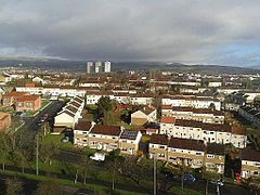
 Looking north over North Blairdardie from high flats | |
Location within Glasgow | |
| OS grid reference | NS527702 |
| Council area | |
| Lieutenancy area |
|
| Country | Scotland |
| Sovereign state | United Kingdom |
| Post town | GLASGOW |
| Postcode district | G15 6 |
| Dialling code | 0141 |
| Police | Scotland |
| Fire | Scottish |
| Ambulance | Scottish |
| UK Parliament | |
| Scottish Parliament | |
Blairdardie is a neighbourhood in the Scottish city of Glasgow. It is situated north of the River Clyde in the north-west of the city and is surrounded by other residential areas: High Knightswood, Knightswood, Old Drumchapel, Drumchapel and Garscadden. It was built between the 1950s and early 1960s.[1]


Description[edit]
The main thoroughfare, Great Western Road (A82) runs right through the middle creating a 'South Blairdardie' (Keal Avenue, Keal Crescent, Keal Drive) which extends to the Forth and Clyde Canal and a 'North Blairdardie' which extends to Drumchapel Road in the north.
North Blairdardie consists of mostly terraced houses, which were council built and are now a mixture of owner-occupied and rented. Blairdardie Pavilion hosts football pitches, a skateboarding club and various youth and children's clubs. There are two primary schools, Blairdardie Primary[2] (rebuilt in 2019, linked to Knightswood Secondary School)[3][4] and St Ninian's Primary,[5] linked to St Thomas Aquinas Secondary School. The area is served by Drumchapel railway station, and there is a retail park[6] and a small industrial estate to the west.
South Blairdardie, geographically small but containing housing of higher density than the north part, is made up of mostly council-built low-rise flats of up to five storeys. There are, four landmark multi-storey flats situated along Great Western Road;[7][8] these towers underwent extensive renovation in 2007. There are further areas of open ground for recreation near to this area at Petersen Park and Knightswood Park.
The area is within Drumchapel/Anniesland Ward (Ward 14) of Glasgow City Council and is represented by Cllr Judith Fisher, Cllr Paul Carey, Cllr Malcolm Balfour and Bailie Jonathan Findlay. Blairdardie also has an active community council. The Westminster constituency is Glasgow North West and is represented by Carol Monaghan MP. The Holyrood constituency is Glasgow Anniesland and is represented by Bill Kidd MSP.
See also[edit]
References[edit]
- ^ West Glasgow (West of Scotland Archaeology Service, 1950), The Glasgow Story
- ^ Welcome, Blairdardie Primary School
- ^ Plans revealed for new state-of-the-art Blairdardie Primary School, Glasgow Live, 13 January 2017
- ^ Blairdardie Primary replaces bollards for pupil safety, Clydebank Post, 11 June 2019
- ^ Welcome, St Ninian's Primary
- ^ Home, Great Western Retail Park
- ^ "Tower Block UK: Blairdardie South". University of Edinburgh. Retrieved 13 January 2019.
- ^ "Buildings in Glasgow: Keal Crescent". Emporis. Archived from the original on 27 February 2019. Retrieved 27 February 2019.
External links[edit]
 Media related to Blairdardie at Wikimedia Commons
- Balirdardie at Gazetteer for Scotland
- Community council
- Blairdardie profile at Understanding Glasgow
