Bazentin | |
|---|---|
 Lamarck's memorial | |
 Coat of arms | |
Location of Bazentin  | |
 Bazentin  Bazentin | |
| Coordinates: 50°01′52″N 2°45′50″E / 50.031°N 2.7639°E | |
| Country | France |
| Region | Hauts-de-France |
| Department | Somme |
| Arrondissement | Péronne |
| Canton | Albert |
| Intercommunality | CC du Pays du Coquelicot |
| Government | |
| • Mayor (2020–2026) | Jean-Luc Fourdinier[1] |
| Area 1 | 5.1 km2 (2.0 sq mi) |
| Population (2021)[2] | 80 |
| • Density | 16/km2 (41/sq mi) |
| Time zone | UTC+01:00 (CET) |
| • Summer (DST) | UTC+02:00 (CEST) |
| INSEE/Postal code | 80059 /80300 |
| Elevation | 94–159 m (308–522 ft) (avg. 90 m or 300 ft) |
| 1 French Land Register data, which excludes lakes, ponds, glaciers > 1 km2 (0.386 sq mi or 247 acres) and river estuaries. | |
Bazentin (French pronunciation: [bazɑ̃tɛ̃]) is a commune in the Somme department in Hauts-de-France in northern France.
Geography[edit]
Situated between Amiens to the southwest and Arras to the north, on the D73 road.
Population[edit]
| Year | Pop. | ±% p.a. |
|---|---|---|
| 1968 | 114 | — |
| 1975 | 82 | −4.60% |
| 1982 | 74 | −1.46% |
| 1990 | 70 | −0.69% |
| 1999 | 77 | +1.06% |
| 2007 | 71 | −1.01% |
| 2012 | 77 | +1.64% |
| 2017 | 79 | +0.51% |
| Source: INSEE[3] | ||
History[edit]
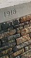
- 1914–1918: The village, in the middle of the war zone, was completely destroyed.
Places and monuments[edit]
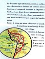
- Memorial to the naturalist Jean-Baptiste Lamarck
- Bazentin-le-Petit Military Cemetery
- Bazentin-le-Petit Communal Cemetery Extension
People[edit]
- Birthplace of Jean-Baptiste Lamarck, 1 August 1744
Gallery[edit]
-
 Plaque denoting Lamarck's birthplace
 -
 Cemetery entrance
 -
 Information board in the village
 -
 The church


See also[edit]
References[edit]
- ^ "Répertoire national des élus: les maires". data.gouv.fr, Plateforme ouverte des données publiques françaises (in French). 2 December 2020.
- ^ "Populations légales 2021". The National Institute of Statistics and Economic Studies. 28 December 2023.
- ^ Population en historique depuis 1968, INSEE
External links[edit]
(All French language)
- Official municipal website Archived 2008-07-05 at the Wayback Machine
- Clochers.org Photos of the church (Taken in 2005 by Claude DEROLETZ)
- Bazentin-le-Petit Communal Cemetery
- South Africans buried in Bazenin Military Cemetery
| International | |
|---|---|
| National | |