 | |
| Meteorological history | |
|---|---|
| Formed | July 16, 1979 |
| Dissipated | July 29, 1979 |
| Tropical storm | |
| 1-minute sustained (SSHWS/NWS) | |
| Highest winds | 50 mph (85 km/h) |
| Lowest pressure | 997 mbar (hPa); 29.44 inHg |
| Overall effects | |
| Fatalities | 2 direct |
| Damage | $400 million (1979 USD) |
| Areas affected | Leeward Islands, Puerto Rico, Dominican Republic, Haiti, Cuba, Texas, Louisiana, Missouri, Ohio Valley, Kentucky, Virginia |
| IBTrACS | |
Part of the 1979 Atlantic hurricane season | |
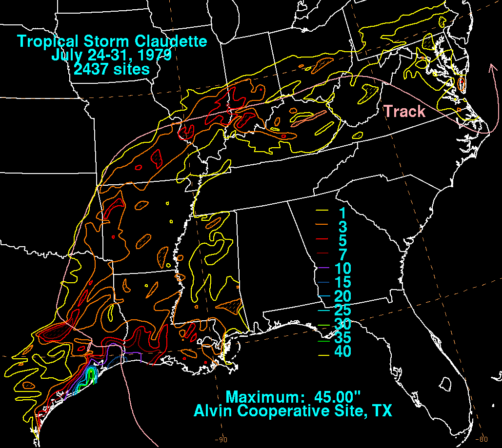
Tropical Storm Claudette was a 1979 tropical cyclone which was the third-wettest tropical cyclone on record in the contiguous United States. The storm caused significant flooding in eastern Texas and western Louisiana in July 1979. The eighth tropical cyclone and third named storm of the 1979 Atlantic hurricane season, Claudette developed from a tropical wave located east of the Windward Islands on July 16. It gradually strengthened and was upgraded to a tropical storm on July 17 and crossed the northern Leeward Islands later that day. As it neared landfall in Puerto Rico early on July 18, upper-level winds weakened it back to a tropical depression. Claudette remained disorganized and the National Hurricane Center operationally reported that it degenerated back into a tropical wave after crossing Puerto Rico. Late on July 18, the depression struck Dominican Republic, emerged into the Caribbean Sea on the following day. Claudette struck western Cuba on July 21, shortly before reaching the Gulf of Mexico and "regenerating" into a tropical cyclone. By July 23, Claudette regained tropical storm intensity and turned northward toward the Gulf Coast of the United States. The storm made landfall near the Texas-Louisiana border late on July 23 as a moderately strong tropical storm. It weakened slowly and drifted over land, lasting until dissipation in West Virginia on July 29.
In the Lesser Antilles, the storm brought heavy rainfall and gusty winds to several islands. Minor flooding occurred in Guadeloupe and Saint Croix. Rainfall exceeding 10 inches (250 mm) in some areas of Puerto Rico led to widespread agricultural damage, flooded homes and streets, and one fatality; losses were estimated at $750,000 (1979 USD). Despite its passage over Hispaniola and Cuba, impact in both regions is unknown. Claudette brought record-breaking rainfall to eastern Texas. In Alvin, 42 inches (1,100 mm) of rain fell in one day, which at one point was the record 24‑hour precipitation amount for any location in the United States. Significant coastal flooding and up to 15 inches (380 mm) of rainfall was reported in Louisiana. Overall, Claudette was responsible for two deaths and $400 million (1979 USD) in damage.
Meteorological history[edit]

Tropical storm (39–73 mph, 63–118 km/h)
Category 1 (74–95 mph, 119–153 km/h)
Category 2 (96–110 mph, 154–177 km/h)
Category 3 (111–129 mph, 178–208 km/h)
Category 4 (130–156 mph, 209–251 km/h)
Category 5 (≥157 mph, ≥252 km/h)
Unknown
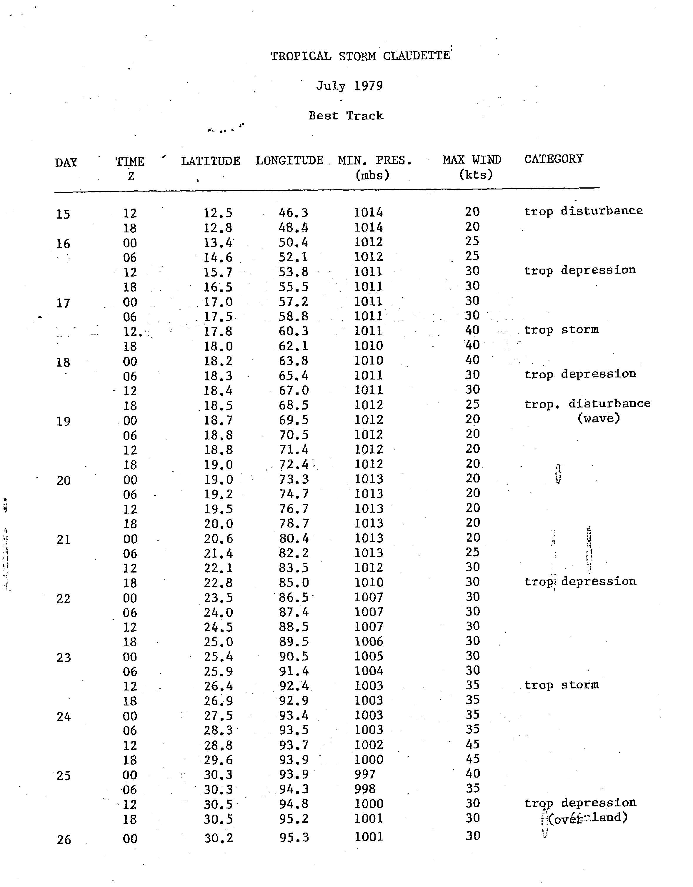
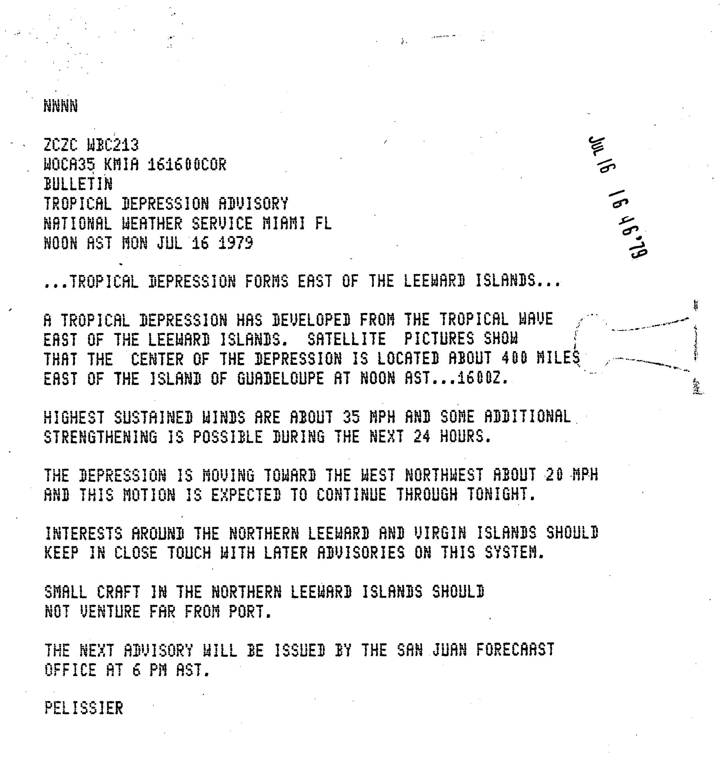
A tropical wave, the strongest of the season at mid-tropospheric levels, emerged into the Atlantic in the second week of July. In Dakar, Senegal, winds were as high as 100 mph (155 km/h) in the 550 mbar (16 inHg) level of the atmosphere. The wave tracked westward and slowly organized.[1] It is estimated that a tropical depression developed after a surface circulation became evident at 1200 UTC on July 16.[2] Four hours later, the National Hurricane Center initiated advisories on Tropical Depression Five, which was centered about 400 miles (640 km) east of Guadeloupe.[3] The depression moved west-northwestward and approached the northern Lesser Antilles. On July 17, an Air Force reconnaissance aircraft flight reported sustained winds of 52 mph (84 km/h). As a result, the depression was upgraded to Tropical Storm Claudette later that day.[1]
As the storm moved westward, it encountered wind shear, weakening it back to depression status when it hit Puerto Rico. Claudette moved across islands of Hispaniola and Cuba as a tropical depression before reforming in the Gulf of Mexico on July 21. Fluctuating between tropical depression and tropical storm status, the disorganized storm drifted slowly westward before making landfall along the Texas-Louisiana border on July 24. The storm stalled over Alvin, Texas, on the evening of the 25th. The storm then weakened and continued northeastward through the Ohio Valley before dissipating on July 29.
Impact[edit]
Tropical Storm Claudette killed 2 people and left $400 million (1979 USD, $1.1 billion 2005 USD).
Eastern Caribbean[edit]

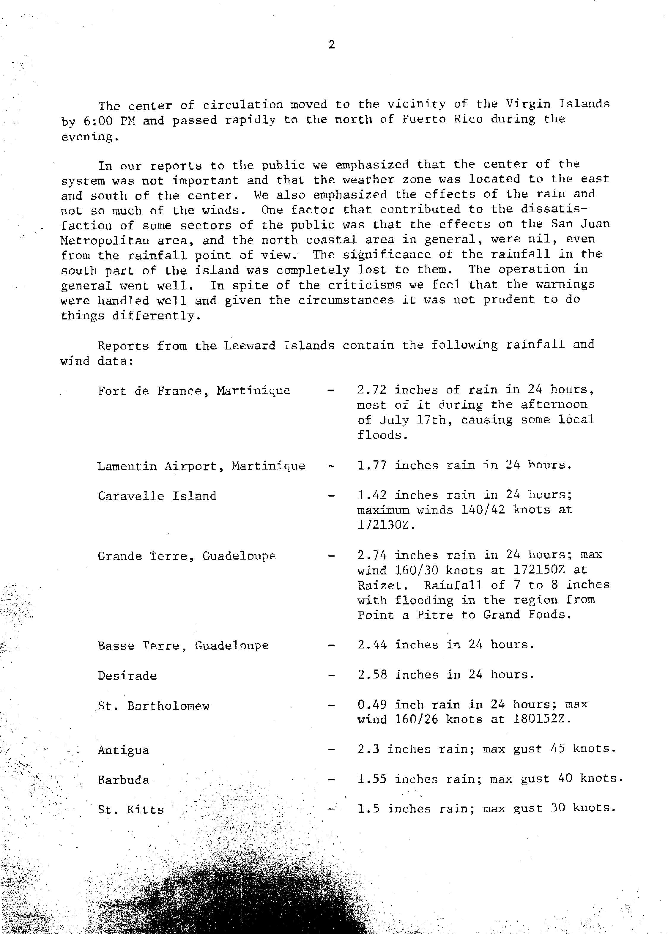
In Fort-de-France, Martinique, 2.72 inches (69 mm) of rain fell in 24 hours, causing localized flooding. Another total of 1.77 inches (45 mm) was measured at the Martinique Aimé Césaire International Airport. Precipitation amounts between 7 and 8 inches (180 and 200 mm) on Guadeloupe resulted in flooding between Pointe-à-Pitre and Grand Fonds. Only 0.49 inches (12 mm) of rain fell on Saint Barthélemy. Rainfall amounted to 2.3 inches (58 mm) on Antigua and wind gusts reached 52 mph (84 km/h), while precipitation totals reached 1.55 inches (39 mm) and gusts up to 46 mph (74 km/h) were reported on Barbuda. On Saint Kitts, rainfall peaked at 1.5 inches (38 mm) and wind gusts topped at 35 mph (56 km/h).[4]
In the United States Virgin Islands, Claudette dropped 5 inches (130 mm) of rain in less than 12 hours on the island of Saint Croix. Runoff from Blue Mountain caused a normally dry creek bed to overflow, flooding several homes in the Mon Bijou area. Additionally, about 25 families were evacuated in the vicinity of Glynn by the Civil Defense.[5]
Claudette produced up to 10.12 inches (257 mm) of precipitation in Puerto Rico, which was recorded in municipality of Peñuelas. Due to heavy rainfall, about 25 families were evacuated in Quebrada Limón by the Civil Defense. One fatality occurred when an attempted to drive across a swollen creek near Guayanilla. A bridge along the Coayuco River linking Yauco to Quebrada Limón was damaged by the abnormally high water levels of the river. Minor flooding was reported in the Ponce Area was the Río Portugués and Río Bucaná overflowed. Excess rainfall caused the Río Guanajibo to inundate streets to a "considerable" extent in Mayagüez. Widespread agricultural damage was reported, especially in Las Marías, Maricao, Sabana Grande, and San Sebastián. Overall, losses in Puerto Rico amounted to about $750,000 (1979 USD).[5]
United States[edit]

Texas[edit]
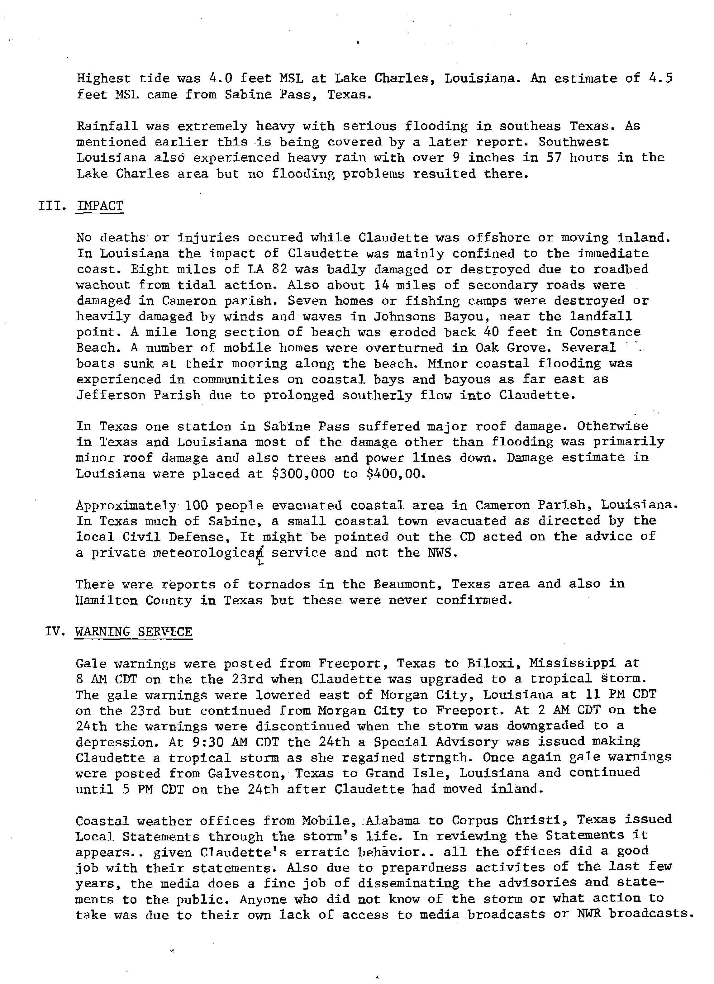
Claudette produced torrential rains in both Texas and Louisiana when it made landfall. The highest one-day total was reported near Alvin, Texas where 42 inches (1,100 mm) of rain fell. This remained as the highest twenty-four-hour rainfall record for any location in the United States until the 2018 Kauai floods, when 49.69 inches (1,262 mm) of rain fell in 24 hours in Waipā Garden, Kauai, Hawaii.[6] Two other towns also reported rainfall totals exceeding 30 inches (760 mm).[7] There was only one death from drowning and Louisiana received only minor damage from up to 15 inches (380 mm) of rainfall.[8] Texas was hard hit by Claudette, with flooding reported in southeast Texas from up to 45 inches (1,100 mm) of rainfall. Many residents had to be rescued from low-lying areas that were flooded.[9]
Louisiana[edit]
Tides reached 4 feet (1.2 m) mean sea-level in Lake Charles, while seas were 3.9 feet (1.2 m) in Cameron. As a result, significant coastal flooding occurred. 8 miles (13 km) of Louisiana Highway 82 was either seriously damaged or destroyed, while 14 miles (23 km) of secondary roads were impacted in Cameron Parish. Several boats in the region capsized at the beaches. Seven homes and fishing camps were significantly damaged or destroyed by waves and strong winds in Johnson Bayou. At Constance Beach in Cameron Parish, up to 40 feet (12 m) of sand was eroded along a 1 mile (1.6 km) long section.[10]
Elsewhere[edit]
In Missouri, rainfall exceeded 5 inches (130 mm) in some areas. The James River overflowed near Springfield, trapping two elderly women in their home. Heavy rainfall in Farmington backed-up sewer drains, flooded basements, and blew-off large manhole covers. Flood water swept away a car in Ste. Genevieve, washed-out a portion of a sidewalk, and toppled fencing along a baseball field. At the Cover Wagon RV park in Waynesville, flooding damage was approximately $5,000. In Rolla, floodwaters between 3 and 4 feet (0.91 and 1.22 m) forced the evacuation of eight families, and washed out driveways. Cars, sheds, fences, kennels, and butane tanks were swept to other locations. Numerous roads were closed in Christian, Greene, and Taney Counties.[5]
As the remnants of Claudette moved inland, it dumped heavy rains across the Midwest and Ohio Valley. Flooding was reported in Missouri, where heavy rains caused significant flooding near St. Louis.[11] In Indiana, about 9 inches of rain fell and isolated flooding was reported.[12]
Aftermath[edit]
On July 28, 1979, then-President of the United States Jimmy Carter issued a disaster declaration for Texas, allowing the counties of Brazoria, Chambers, Dallas, Galveston, Jefferson and Orange to be eligible for government aid in order to recover from flooding.[13]
See also[edit]
- List of Texas hurricanes
- List of wettest tropical cyclones in Texas
- Other storms of the same name
- 2018 Kauai flood - a flash flood that has an unverified peak 24 hour rainfall of 49.69 in (1,262 mm), which would break Claudette's record
- Hurricane Laura - a stronger storm that would take a similar path to Claudette
References[edit]
- ^ a b "Tropical Storm Claudette Preliminary Report". National Hurricane Center. 1979. Retrieved 5 October 2010.
- ^ "Tropical Storm Claudette July 1979 Best Track". National Hurricane Center. 1979. p. 1. Retrieved October 21, 2012.
- ^ Joseph Pelissier (July 16, 1979). "Tropical Depression Advisory". National Hurricane Center. Retrieved October 21, 2012.
- ^ James Colon (August 16, 1979). "Tropical Storm Claudette". National Weather Service San Juan, Puerto Rico. Retrieved October 20, 2012.
- ^ a b c "Storm Data and Unusual Weather Phenomena" (PDF). National Climatic Data Center. Retrieved October 20, 2012.[permanent dead link]
- ^ [1] Archived 2019-05-09 at the Wayback Machine
- ^ David M. Roth (November 29, 2017). "Tropical Storm Claudette - July 16-31, 1979". Weather Prediction Center. Retrieved April 25, 2018.
- ^ Hydrometeorological Prediction Center. Claudette (1979) Rainfall. Retrieved on 2007-01-13.
- ^ MountWashington.org Archived 2013-04-15 at archive.today
- ^ David Barnes Jr. (August 27, 1979). "Tropical Storm Claudette Report". National Hurricane Center. p. 4. Retrieved October 20, 2012.
- ^ NOAA Data
- ^ Kansas Water Publication
- ^ United States Department of Homeland Security. "Designated Counties: Texas Storms, Flash Floods". Federal Emergency Management Agency. Archived from the original on December 12, 2012. Retrieved October 20, 2012.
External links[edit]
Tropical cyclones of the 1979 Atlantic hurricane season | ||
|---|---|---|
 | ||