| Sturgeon Point State Park | |
|---|---|
 | |
| Location | Alcona County, Michigan, United States |
| Nearest city | Harrisville, Michigan |
| Coordinates | 44°42′42″N 83°16′20″W / 44.71167°N 83.27222°W [2] |
| Area | 76 acres (31 ha) |
| Elevation | 581 feet (177 m) [2] |
| Designation | Michigan state park |
| Established | 1960[3] |
| Administrator | Michigan Department of Natural Resources |
| Website | Sturgeon Point State Park |
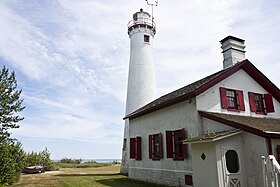
Sturgeon Point State Park is an undeveloped public recreation area that is home to the historic Sturgeon Point Light. The state park covers 76 acres (31 ha) on the shore of Lake Huron three miles (4.8 km) north of Harrisville in Alcona County, Michigan. In addition to the lighthouse and associated museum, the park features a long and shallow reef that juts into Lake Huron and extends for almost a full mile. The park is used for lighthouse visits, swimming, and viewing various Michigan flora and fauna.[4]
References[edit]
- ^ "Sturgeon Point State Park". Protected Planet. IUCN. Retrieved March 26, 2020.
- ^ a b "Sturgeon Point State Park". Geographic Names Information System. United States Geological Survey, United States Department of the Interior.
- ^ "When were Michigan state parks and recreation areas established?" (PDF). Michigan Department of Natural Resources. Retrieved March 26, 2020.
- ^ "Sturgeon Point State Park". Michigan Department of Natural Resources. Retrieved March 26, 2020.
External links[edit]
- Sturgeon Point State Park Michigan Department of Natural Resources
- Sturgeon Point State Park Map Michigan Department of Natural Resources

