St. Stephens, North Carolina | |
|---|---|
 Location of St. Stephens in North Carolina | |
| Coordinates: 35°45′51″N 81°16′28″W / 35.76417°N 81.27444°W | |
| Country | United States |
| State | North Carolina |
| County | Catawba |
| Area | |
| • Total | 9.65 sq mi (24.99 km2) |
| • Land | 9.30 sq mi (24.08 km2) |
| • Water | 0.35 sq mi (0.91 km2) |
| Elevation | 1,099 ft (335 m) |
| Population (2020) | |
| • Total | 8,852 |
| • Density | 952.14/sq mi (367.62/km2) |
| Time zone | UTC-5 (Eastern (EST)) |
| • Summer (DST) | UTC-4 (EDT) |
| FIPS code | 37-58730[3] |
| GNIS feature ID | 2402814[2] |
St. Stephens is a census-designated place (CDP) in Catawba County, North Carolina, United States. The population was 8,759 at the 2010 census,[4] down from 9,439 in 2000. It is part of the Hickory–Lenoir–Morganton Metropolitan Statistical Area.
Geography[edit]
St. Stephens is located in northern Catawba County. It is bordered on the west by the city of Hickory, on the south by the city of Conover, and on the north by Alexander County, separated from St. Stephens by Lake Hickory on the Catawba River.
According to the United States Census Bureau, the CDP has a total area of 9.9 square miles (25.7 km2), of which 9.5 square miles (24.6 km2) is land and 0.42 square miles (1.1 km2), or 4.09%, is water. The area of the CDP has declined from 10.2 square miles (26.4 km2) at the 2000 census due to annexation by the neighboring cities.
Demographics[edit]
| Census | Pop. | Note | %± |
|---|---|---|---|
| 2020 | 8,852 | — | |
| U.S. Decennial Census[5] | |||
2020 census[edit]
| Race | Number | Percentage |
|---|---|---|
| White (non-Hispanic) | 5,945 | 67.16% |
| Black or African American (non-Hispanic) | 351 | 3.97% |
| Native American | 26 | 0.29% |
| Asian | 501 | 5.66% |
| Pacific Islander | 1 | 0.01% |
| Other/Mixed | 405 | 4.58% |
| Hispanic or Latino | 1,623 | 18.33% |
As of the 2020 United States census, there were 8,852 people, 3,609 households, and 2,527 families residing in the CDP.
2000 census[edit]
As of the census[3] of 2000, there were 9,439 people, 3,506 households, and 2,675 families residing in the CDP. The population density was 962.2 inhabitants per square mile (371.5/km2). There were 3,683 housing units at an average density of 375.4 per square mile (144.9/km2). The racial makeup of the CDP was 88.77% White, 2.67% African American, 0.42% Native American, 2.79% Asian, 0.03% Pacific Islander, 4.06% from other races, and 1.26% from two or more races. Hispanic or Latino of any race were 9.76% of the population.
There were 3,509 households, out of which 34.1% had children under the age of 18 living with them, 60.8% were married couples living together, 10.0% had a female householder with no husband present, and 23.7% were non-families. 19.6% of all households were made up of individuals, and 7.2% had someone living alone who was 65 years of age or older. The average household size was 2.66 and the average family size was 3.01.
In the CDP, the population was spread out, with 24.6% under the age of 18, 9.3% from 18 to 24, 30.6% from 25 to 44, 24.0% from 45 to 64, and 11.5% who were 65 years of age or older. The median age was 36 years. For every 100 females, there were 104.5 males. For every 100 females age 18 and over, there were 101.2 males.
The median income for a household in the CDP was $41,790, and the median income for a family was $45,763. Males had a median income of $29,452 versus $24,248 for females. The per capita income for the CDP was $18,038. About 5.7% of families and 7.1% of the population were below the poverty line, including 8.2% of those under age 18 and 7.4% of those age 65 or over.
References[edit]
- ^ "ArcGIS REST Services Directory". United States Census Bureau. Retrieved September 20, 2022.
- ^ a b U.S. Geological Survey Geographic Names Information System: St. Stephens, North Carolina
- ^ a b "U.S. Census website". United States Census Bureau. Retrieved 2008-01-31.
- ^ "Geographic Identifiers: 2010 Demographic Profile Data (G001): St. Stephens CDP, North Carolina". U.S. Census Bureau, American Factfinder. Archived from the original on February 12, 2020. Retrieved December 29, 2014.
- ^ "Census of Population and Housing". Census.gov. Retrieved June 4, 2016.
- ^ "Explore Census Data". data.census.gov. Retrieved 2021-12-21.
Municipalities and communities of Catawba County, North Carolina, United States | ||
|---|---|---|
| Cities | 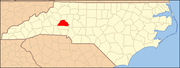 | |
| Towns | ||
| CDPs | ||
| Unincorporated communities | ||
| Footnotes | ‡This populated place also has portions in an adjacent county or counties | |