Sürmene | |
|---|---|
District and municipality | |
 Memiş Ağa Mansion in Sürmene | |
 Map showing Sürmene District in Trabzon Province | |
 Sürmene Location in Turkey | |
| Coordinates: 40°54′51″N 40°06′45″E / 40.91417°N 40.11250°E | |
| Country | Turkey |
| Province | Trabzon |
| Government | |
| • Mayor | Rahmi Üstün (AKP) |
| Area | 166 km2 (64 sq mi) |
| Elevation | 20 m (70 ft) |
| Population (2022)[1] | 25,950 |
| • Density | 160/km2 (400/sq mi) |
| Time zone | UTC+3 (TRT) |
| Postal code | 61600 |
| Area code | 0462 |
| Climate | Cfa |
| Website | www |
Sürmene (Turkish: [syɾˈmene]; Greek: Σούρμενα, Sourmena; Ottoman Turkish: ﺳﻮرﻣﻨﻪ, romanized as Sürmena[/e]) is a municipality and district of Trabzon Province, Turkey.[2] Its area is 166 km2,[3] and its population is 25,950 (2022).[1] In ancient times the town of Hyssus or Hyssos (Ancient Greek: Υσσός) was nearby.[4] The mayor is Rahmi Üstün (AKP).
Sürmene (Humurgan)[5] is situated some 40 km (25 mi) east of Trabzon. Known in antiquity also as Susarmia or Augustopolis,[citation needed] it lies on the River Kora (Manahoz Deresi) and is best known as the place where Xenophon and his Ten Thousand fell sick after eating wild honey, an event which was confirmed by the local people. In the village of Kastil, 5 km (3.1 mi) to the west of Sürmene, stands a ruined medieval castle as well as the impressively restored 18th-century Yakupoğlu Memiş Ağa Konağı mansion. This was formerly the seat of the Yakupoğlu family, who lived here as rulers (derebeys, hence its alternative name of Derebeyli Kale, the Castle of the Derebeys) of the surrounding region relatively free of interference from the Ottoman government in faraway Constantinople/Istanbul.
Economy[edit]
Historically, Sürmene produced small amounts of manganese. The area also had mineral springs, and shipped bottled water to Istanbul.[6]
Composition[edit]
There are 37 neighbourhoods in Sürmene District:[7]
- Aksu
- Armutlu
- Aşağıovalı
- Balıklı
- Birlik
- Çamburnu
- Çamlıca
- Çarşı
- Çavuşlu
- Çiftesu
- Çimenli
- Dirlik
- Fındıcak
- Gültepe
- Güneyköy
- Kahraman
- Karacakaya
- Konak
- Koyuncular
- Küçükdere
- Muratlı
- Ormanseven
- Ortaköy
- Ortamahalle
- Oylum
- Petekli
- Soğuksu
- Üstündal
- Üzümlü
- Yazıoba
- Yemişli
- Yeniay
- Yeşilköy
- Yokuşbaşı
- Yukarıçavuşlu
- Yukarıovalı
- Zeytinli
Flora and fauna[edit]
According to WWF the largest amount of endemic flora is to be found in the Ağaçbaşı yayla (summer upland pasture) in Sürmene.[8]
- Zehirli biberiye (Andromeda polifolia),
- Böcek yiyen bitkilerden Drosera,
- Pamukotu (Eriophorum angustifolium ve E. latifolium),
- Kurtayağı (Lycopodiella inundata),
- Kara ot (Rhynchospora alba)
Gallery[edit]
-
 The Sürmeme Chamber of Commerce was the first chamber of commerce in Turkey
 -
-
 [9] Çavuşzade Muhammed Ağa's gravestone
 -
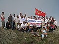 Sürmene Festival on the top of Madur mountain.
 -
 Fatih Akın Turkish film director from Çamburnu, a village of Sürmene
 -
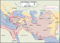 The route that brought Xenophon's Ten Thousand to Sürmene


See also[edit]
References[edit]
- ^ a b "Address-based population registration system (ADNKS) results dated 31 December 2022, Favorite Reports" (XLS). TÜİK. Retrieved 19 September 2023.
- ^ Büyükşehir İlçe Belediyesi, Turkey Civil Administration Departments Inventory. Retrieved 19 September 2023.
- ^ "İl ve İlçe Yüz ölçümleri". General Directorate of Mapping. Retrieved 19 September 2023.
- ^ "An Overview of Rize's History". Republic of Turkey Ministry of Culture and Tourism. Archived from the original on September 29, 2007. Retrieved 2008-04-11.
- ^ "Humurgan". T.C. Kültür ve Turizm Bakanlığı. Retrieved 8 March 2023.
- ^ Prothero, W. G. (1920). Armenia and Kurdistan. London: H.M. Stationery Office. p. 73.
- ^ Mahalle, Turkey Civil Administration Departments Inventory. Retrieved 19 September 2023.
- ^ [1][permanent dead link]
- ^ "Çavuşpaşa.ni̇noğlu. Muhammetağa. Bölük.no.13.Öl. 1718".
External links[edit]
- District governor's official website
- District municipality's official website* Surmenem.com - A local website about Sürmene
Sürmene in Trabzon Province of Turkey | |||||||||||||||||||||||||||
|---|---|---|---|---|---|---|---|---|---|---|---|---|---|---|---|---|---|---|---|---|---|---|---|---|---|---|---|
| Districts |   | ||||||||||||||||||||||||||
|
Metropolitan municipalities are bolded. | |||||||||||||||||||||||||||
| Authority control databases: National |
|---|