Rozendaal | |
|---|---|
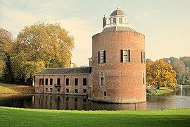
 Rozendaal Castle | |
 Flag  Coat of arms | |
 Location in Gelderland | |
| Coordinates: 52°0′N 5°58′E / 52.000°N 5.967°E | |
| Country | Netherlands |
| Province | Gelderland |
| Government | |
| • Body | Municipal council |
| • Mayor | Ester Weststeijn |
| Area | |
| • Total | 27.92 km2 (10.78 sq mi) |
| • Land | 27.90 km2 (10.77 sq mi) |
| • Water | 0.02 km2 (0.008 sq mi) |
| Elevation | 41 m (135 ft) |
| Population (January 2021)[4] | |
| • Total | 1,726 |
| • Density | 62/km2 (160/sq mi) |
| Time zone | UTC+1 (CET) |
| • Summer (DST) | UTC+2 (CEST) |
| Postcode | 6891 |
| Area code | 026 |
| Website | www |
Rozendaal (Dutch pronunciation: [ˈroːzə(n)ˌdaːl] ⓘ) is a municipality and a town in the eastern Netherlands, in the province of Gelderland. The town, next to Arnhem and Velp, is known for the Rozendaal Castle (Kasteel Rosendael) and its water fountain follies (bedriegertjes).
The municipality is the least densely populated on the mainland of the Netherlands, i.e., in effect, not on one of the West Frisian Islands. Rozendaal is one of the richest municipalities in the Netherlands.[5]
Population centres[edit]
- Imbosch
- Rozendaal
- Terlet
Topography[edit]

Dutch topographic map of the municipality of Rozendaal, June 2015
Notable people[edit]
- Petrus Augustus de Génestet (1829 – 1861 in Rozendaal) a Dutch poet and theologian
Gallery[edit]
-
 Tower of castle Rozendaal
 -
 The Salvation Army Hospice Rozenheuvel at Rozendaal
 -
 Theehuis, Rozendaal Park
 -
 Kasteel Rosendael seen from one of the ponds
 -
 Rozendaals Veld near the Brandtoren
 -
 The bedriegertjes in the Rozendaal Castle parks
 -
 The schelpengalerij (shell gallery) in the Rozendaal Castle parks
 -
 The town hall of the Rozendaal Municipality


References[edit]
- ^ "Samenstelling" [Members] (in Dutch). Gemeente Rozendaal. Retrieved 25 March 2023.
- ^ "Kerncijfers wijken en buurten 2020" [Key figures for neighbourhoods 2020]. StatLine (in Dutch). CBS. 24 July 2020. Retrieved 19 September 2020.
- ^ "Postcodetool for 6891CL". Actueel Hoogtebestand Nederland (in Dutch). Het Waterschapshuis. Retrieved 17 July 2014.
- ^ "Bevolkingsontwikkeling; regio per maand" [Population growth; regions per month]. CBS Statline (in Dutch). CBS. 1 January 2021. Retrieved 2 January 2022.
- ^ "Bureau voor Statistiek". Centraal Bureau voor Statistiek. Retrieved 11 July 2018.
External links[edit]
 Media related to Rozendaal at Wikimedia Commons
- Official website (in Dutch)

| International | |
|---|---|
| National | |