Florence, Wisconsin | |
|---|---|
Census-designated place | |
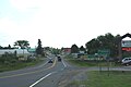
 Looking west at downtown Florence | |
 Florence, Wisconsin | |
| Coordinates: 45°55′20″N 88°15′06″W / 45.92222°N 88.25167°W | |
| Country | United States |
| State | Wisconsin |
| County | Florence |
| Area | |
| • Total | 1.783 sq mi (4.62 km2) |
| • Land | 1.704 sq mi (4.41 km2) |
| • Water | 0.079 sq mi (0.20 km2) |
| Elevation | 1,306 ft (398 m) |
| Population (2010) | |
| • Total | 592 |
| • Density | 330/sq mi (130/km2) |
| Time zone | UTC-6 (Central (CST)) |
| • Summer (DST) | UTC-5 (CDT) |
| ZIP code | 54121 |
| Area code(s) | 715 & 534 |
| GNIS feature ID | 1565079[1] |
Florence is a census-designated place in and the county seat of Florence County, Wisconsin, United States.[1][2] Florence is located in northern Florence County, in the town of Florence. Florence has a post office with ZIP code 54121.[3] The community was named a census-designated place in 2010.[4] As of the 2010 census, its population was 592.[5]
History[edit]
Florence and the area surrounding belonged to the Menominee and was a hunting and trapping region until iron was discovered there in the 1870s. The Florence Mine was discovered in October 1874 by H. D. Fisher. The mine was named in 1879 after the wife of Nelson Powell Hulst, Florence Terry Hulst.
We all wish to call the new town and the mine Florence, to honor the first white woman who had courage enough to settle (for a while) in that rugged country.
I mean the first white woman known to us.
Will you permit your name to be used?
— J. J. Hagerman, in a letter to Florence Terry Hulst (December 15, 1879)
The county subsequently took on the same name.[6][7][8]
Geography[edit]
Florence is located at 45°55′20″N 88°15′06″W / 45.92222°N 88.25167°W at an elevation of 1,306 feet (398 m). Florence is situated in the Northern Highland region of Wisconsin near the Michigan border. Fisher Lake is located to the south of the community, and Fisher Creek runs to its east. The community of Commonwealth is 1 mile (1.6 km) south of Florence. The nearest city to Florence is Iron Mountain, which is 11.5 miles (18.5 km) to the southeast; Florence County has no incorporated communities. US Highway 2 and US Highway 141 run through the community, and Wisconsin Highway 70 and Wisconsin Highway 101 terminate in western Florence; County Highway N also serves the community.[9]
Education[edit]
Florence High School is the area's public high school.
Notable people[edit]
- Kenneth L. Greenquist, member of the Wisconsin State Senate, was born in Florence.[10][11]
- Charles White Whittlesey, Medal of Honor recipient in World War I, was born in Florence.
Images[edit]
-

-
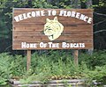 Welcome sign
 -
-
 Fire department
 -
 Post office
 -
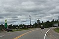
 Looking east at Florence on US2 / US141
 -


See also[edit]
References[edit]
- ^ a b U.S. Geological Survey Geographic Names Information System: Florence (CDP), Wisconsin
- ^ "Find a County". National Association of Counties. Archived from the original on May 31, 2011. Retrieved June 7, 2011.
- ^ ZIP Code Lookup
- ^ U.S. Geological Survey Geographic Names Information System: Florence Census Designated Place
- ^ "U.S. Census website". U.S. Census Bureau. Retrieved April 3, 2011.
- ^ Wood, Howard (1920). "The History of Florence County". The Wisconsin Magazine of History. 3 (4): 466–467. Retrieved February 19, 2023.
- ^ Usher, Ellis B. (1923). "Nelson Powell Hulst". The Wisconsin Magazine of History. 7: 394–395. Retrieved February 19, 2023.
- ^ "Pioneer Life on the Menominee Iron Range" (PDF). uproc.lib.mi.us. Menominee Range Historical Foundation. Retrieved February 19, 2023.
- ^ Florence County Map (PDF) (Map). Wisconsin Department of Transportation. Archived from the original (pdf) on May 16, 2008. Retrieved August 29, 2010.
- ^ "Members of the legislature". The Wisconsin Blue Book, 1940. State of Wisconsin. 1940. p. 31. Retrieved November 22, 2013.
- ^ "Kenneth Greenquist, 58, Succumbs at Hospital". Fond du Lac Commonwealth Reporter. April 5, 1968. p. 1. Retrieved July 29, 2016 – via Newspapers.com.

External links[edit]
Municipalities and communities of Florence County, Wisconsin, United States | ||
|---|---|---|
| Towns |  | |
| CDPs | ||
| Unincorporated communities | ||
| International | |
|---|---|
| National | |