
Size of this preview: 564 × 599 pixels. Other resolutions: 226 × 240 pixels | 452 × 480 pixels | 723 × 768 pixels | 964 × 1,024 pixels | 2,354 × 2,501 pixels.
Original file (2,354 × 2,501 pixels, file size: 1.12 MB, MIME type: image/png)
Summary
| Description |
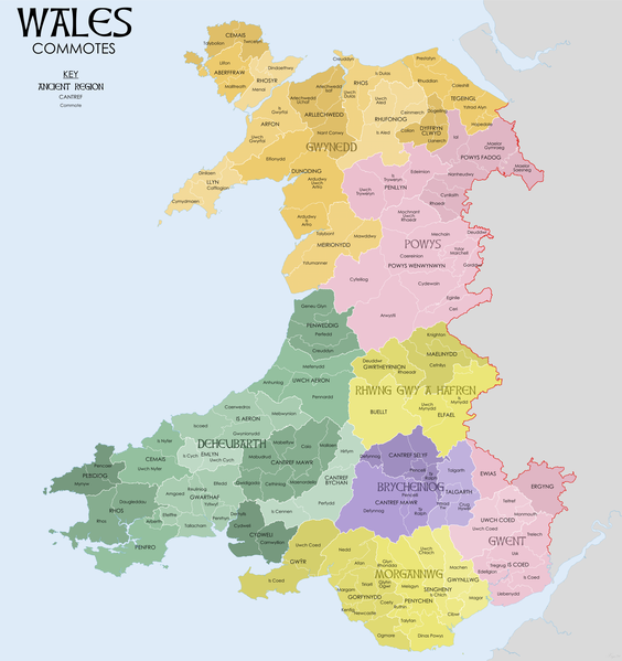
English: Map of the commotes of Medieval Wales. Source data: RCAHMW Mapping the Medieval Cantrefi and Commotes of Wales (https://rcahmw.gov.uk/mapping-the-historic-boundaries-of-wales-commotes-and-cantrefs/) South Wales and the Border in the Fourteenth Century (1933) W.M.Rees. Kain, R.J.P., and Oliver, R.R. (2001) "Historic parishes of England and Wales" |
| Date | |
| Source | Own work |
| Author | XrysD |
Licensing
I, the copyright holder of this work, hereby publish it under the following license:
This file is licensed under the Creative Commons Attribution-Share Alike 4.0 International license.
- You are free:
- to share – to copy, distribute and transmit the work
- to remix – to adapt the work
- Under the following conditions:
- attribution – You must give appropriate credit, provide a link to the license, and indicate if changes were made. You may do so in any reasonable manner, but not in any way that suggests the licensor endorses you or your use.
- share alike – If you remix, transform, or build upon the material, you must distribute your contributions under the same or compatible license as the original.
File history
Click on a date/time to view the file as it appeared at that time.
| Date/Time | Thumbnail | Dimensions | User | Comment | |
|---|---|---|---|---|---|
| current | 10:04, 28 June 2020 | | 2,354 × 2,501 (1.12 MB) | XrysD | Fixed typo: Arwystll-->Arwystli |
| 08:31, 27 July 2019 |  | 2,354 × 2,501 (1.12 MB) | XrysD | Mistake of Ardudwy Is Artro labelled as Ardudwy Uwch Artro fixed | |
| 18:21, 17 January 2019 |  | 2,354 × 2,501 (1.12 MB) | XrysD | Fixed typo Cyfelliog==>Cyfeiliog | |
| 17:35, 16 May 2018 |  | 3,399 × 3,610 (1.96 MB) | XrysD | User created page with UploadWizard |
File usage
The following pages on the English Wikipedia use this file (pages on other projects are not listed):
Global file usage
The following other wikis use this file:
- Usage on cy.wikipedia.org
- Usage on fr.wikipedia.org
- Usage on gl.wikipedia.org