
Size of this preview: 800 × 543 pixels. Other resolutions: 320 × 217 pixels | 640 × 435 pixels | 1,024 × 696 pixels | 1,280 × 869 pixels | 2,254 × 1,531 pixels.
Original file (2,254 × 1,531 pixels, file size: 3.71 MB, MIME type: image/png)
Summary
| Description |
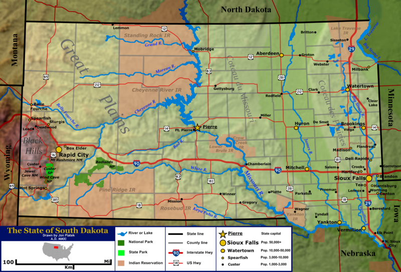
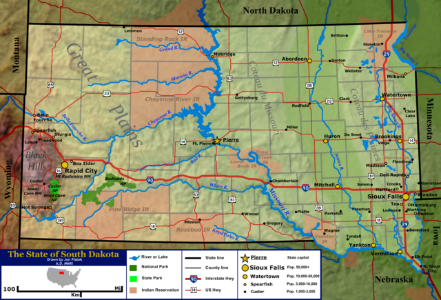
English: General map of the US state of South Dakota. Shown are the state's topography, major cities and roads, boundaries, and bodies of water. |
| Date | |
| Source | Base topography map is from the public domain National Atlas, as were several layers used as reference points. Highway shields were by User:SPUI and released to the public domain. US locator map was by User:Theshibboleth. All other work was done by the uploader. |
| Author | Jon Platek. |
Licensing
I, the copyright holder of this work, hereby publish it under the following licenses:
This file is licensed under the Creative Commons Attribution-Share Alike 3.0 Unported license.
- You are free:
- to share – to copy, distribute and transmit the work
- to remix – to adapt the work
- Under the following conditions:
- attribution – You must give appropriate credit, provide a link to the license, and indicate if changes were made. You may do so in any reasonable manner, but not in any way that suggests the licensor endorses you or your use.
- share alike – If you remix, transform, or build upon the material, you must distribute your contributions under the same or compatible license as the original.

|
Permission is granted to copy, distribute and/or modify this document under the terms of the GNU Free Documentation License, Version 1.2 or any later version published by the Free Software Foundation; with no Invariant Sections, no Front-Cover Texts, and no Back-Cover Texts. A copy of the license is included in the section entitled GNU Free Documentation License. |
You may select the license of your choice.
File history
Click on a date/time to view the file as it appeared at that time.
| Date/Time | Thumbnail | Dimensions | User | Comment | |
|---|---|---|---|---|---|
| current | 18:04, 25 January 2011 | | 2,254 × 1,531 (3.71 MB) | AlexiusHoratius~commonswiki | forgot to label Volga |
| 16:59, 25 January 2011 |  | 2,254 × 1,531 (3.71 MB) | AlexiusHoratius~commonswiki | {{Information |Description ={{en|1=General map of the US state of South Dakota. Shown are the state's topography, major cities and roads, boundaries, and bodies of water.}} |Source ={{own}} |Author =[[User:AlexiusHoratius|AlexiusHoratiu |
File usage
The following pages on the English Wikipedia use this file (pages on other projects are not listed):
Global file usage
The following other wikis use this file:
- Usage on bn.wikipedia.org
- Usage on ca.wikipedia.org
- Usage on ceb.wikipedia.org
- Usage on es.wikipedia.org
- Usage on id.wikipedia.org
- Usage on ja.wikipedia.org
- Usage on ko.wikipedia.org
- Usage on lb.wikipedia.org
- Usage on no.wikipedia.org
- Usage on zh.wikipedia.org