
Size of this PNG preview of this SVG file: 800 × 503 pixels. Other resolutions: 320 × 201 pixels | 640 × 402 pixels | 1,024 × 643 pixels | 1,280 × 804 pixels | 2,560 × 1,609 pixels | 958 × 602 pixels.
Original file (SVG file, nominally 958 × 602 pixels, file size: 200 KB)
Summary
| Description |
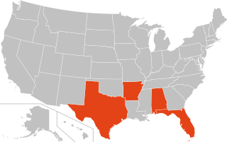
English: Map of U.S. jurisdictions that impose mandatory driver's license suspensions for cannabis possession
Complying states
States that have opted out |
| Date | |
| Source | Derived from Blank US Map (states only) 2.svg by Heitordp |
| Author | Jamesy0627144 |
_2.svg)
Licensing
This file is licensed under the Creative Commons Attribution-Share Alike 3.0 Unported license.
- You are free:
- to share – to copy, distribute and transmit the work
- to remix – to adapt the work
- Under the following conditions:
- attribution – You must give appropriate credit, provide a link to the license, and indicate if changes were made. You may do so in any reasonable manner, but not in any way that suggests the licensor endorses you or your use.
- share alike – If you remix, transform, or build upon the material, you must distribute your contributions under the same or compatible license as the original.
File history
Click on a date/time to view the file as it appeared at that time.
| Date/Time | Thumbnail | Dimensions | User | Comment | |
|---|---|---|---|---|---|
| current | 20:53, 17 June 2020 | | 958 × 602 (200 KB) | Jamesy0627144 | switched to File:Blank US Map (states only) 2.svg as base SVG file which contains various improvements |
| 20:15, 13 April 2020 |  | 959 × 593 (27 KB) | Jamesy0627144 | update Mississippi | |
| 07:15, 20 January 2020 |  | 959 × 593 (27 KB) | Jamesy0627144 | update New Jersey | |
| 06:21, 5 August 2019 |  | 959 × 593 (27 KB) | Jamesy0627144 | fix opt-out state color | |
| 06:16, 5 August 2019 |  | 959 × 593 (27 KB) | Jamesy0627144 | update New York | |
| 03:27, 23 April 2019 |  | 959 × 593 (27 KB) | Jamesy0627144 | Switch to File:Blank US Map (states only).svg as base file which also contains improvements to code. Also fixed title of file. | |
| 06:13, 9 November 2018 |  | 959 × 593 (37 KB) | Jamesy0627144 | update Michigan | |
| 02:06, 1 November 2018 |  | 959 × 593 (37 KB) | Jamesy0627144 | update Pennsylvania | |
| 06:22, 2 September 2018 |  | 959 × 593 (37 KB) | Jamesy0627144 | update Iowa | |
| 22:32, 2 April 2018 |  | 959 × 593 (37 KB) | Jamesy0627144 | update Utah |
_2.svg)
.svg)
File usage
No pages on the English Wikipedia use this file (pages on other projects are not listed).