
Size of this preview: 515 × 599 pixels. Other resolutions: 206 × 240 pixels | 412 × 480 pixels | 660 × 768 pixels | 880 × 1,024 pixels | 1,495 × 1,740 pixels.
Original file (1,495 × 1,740 pixels, file size: 511 KB, MIME type: image/jpeg)
Summary
| Description |
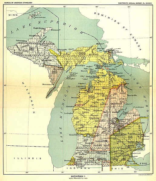
English: This 19th century map, produced by the Smithsonian Institution, depicts the major Native American land cessions that resulted in what is now Michigan.
Français : Carte du 19ème siècle montrant les cessions de territoire des Amérindiens au gouvernement américain dans la région où se trouve aujourd'hui l'état du Michigan. Le territoire en jaune sur la carte a ainsi été cédé aux USA en 1836 lors du traité de Washington. |
| Date | between 1896 and 1897 |
| Source | United States Serial Set Number 4015 contains the second part of the two-part Eighteenth Annual Report of the Bureau of American Ethnology to the Secretary of the Smithsonian Institution, 1896-1897. Indian Land Cessions in the United States, 1784-1894 United States Serial Set, Number 4015 |
| Author | Bureau of American Ethnology |
Licensing
This media file is in the public domain in the United States. This applies to U.S. works where the copyright has expired, often because its first publication occurred prior to January 1, 1929, and if not then due to lack of notice or renewal. See this page for further explanation.
|
 | |
 |
This image might not be in the public domain outside of the United States; this especially applies in the countries and areas that do not apply the rule of the shorter term for US works, such as Canada, Mainland China (not Hong Kong or Macao), Germany, Mexico, and Switzerland. The creator and year of publication are essential information and must be provided. See Wikipedia:Public domain and Wikipedia:Copyrights for more details.
|
Original upload log
The original description page was here. All following user names refer to en.wikipedia.
- 2004-09-29 23:56 Jengod 1495×1740× (522824 bytes) {{PD}} source info in a sec
File history
Click on a date/time to view the file as it appeared at that time.
| Date/Time | Thumbnail | Dimensions | User | Comment | |
|---|---|---|---|---|---|
| current | 15:13, 11 May 2009 | | 1,495 × 1,740 (511 KB) | Sylfred1977 | {{Information |Description={{en|This 19th century map, produced by the Smithsonian Institution, depicts the major Native American land cessions that resulted in what is now Michigan. United States Serial Set Number 4015 contains the second part of the two |
File usage
The following pages on the English Wikipedia use this file (pages on other projects are not listed):
Global file usage
The following other wikis use this file:
- Usage on ca.wikipedia.org
- Usage on es.wikipedia.org
- Usage on fr.wikipedia.org
- Usage on it.wikipedia.org
- Usage on ja.wikipedia.org