Size of this preview: 776 × 600 pixels. Other resolutions: 311 × 240 pixels | 621 × 480 pixels | 994 × 768 pixels | 1,280 × 989 pixels | 2,604 × 2,012 pixels.
Original file (2,604 × 2,012 pixels, file size: 685 KB, MIME type: image/gif)

|
This ethnographic map image could be re-created using vector graphics as an SVG file. This has several advantages; see Commons:Media for cleanup for more information. If an SVG form of this image is available, please upload it and afterwards replace this template with
{{vector version available|new image name}}.
It is recommended to name the SVG file “New 2000 hispanic percent.svg”—then the template Vector version available (or Vva) does not need the new image name parameter. |
Summary
| Description |
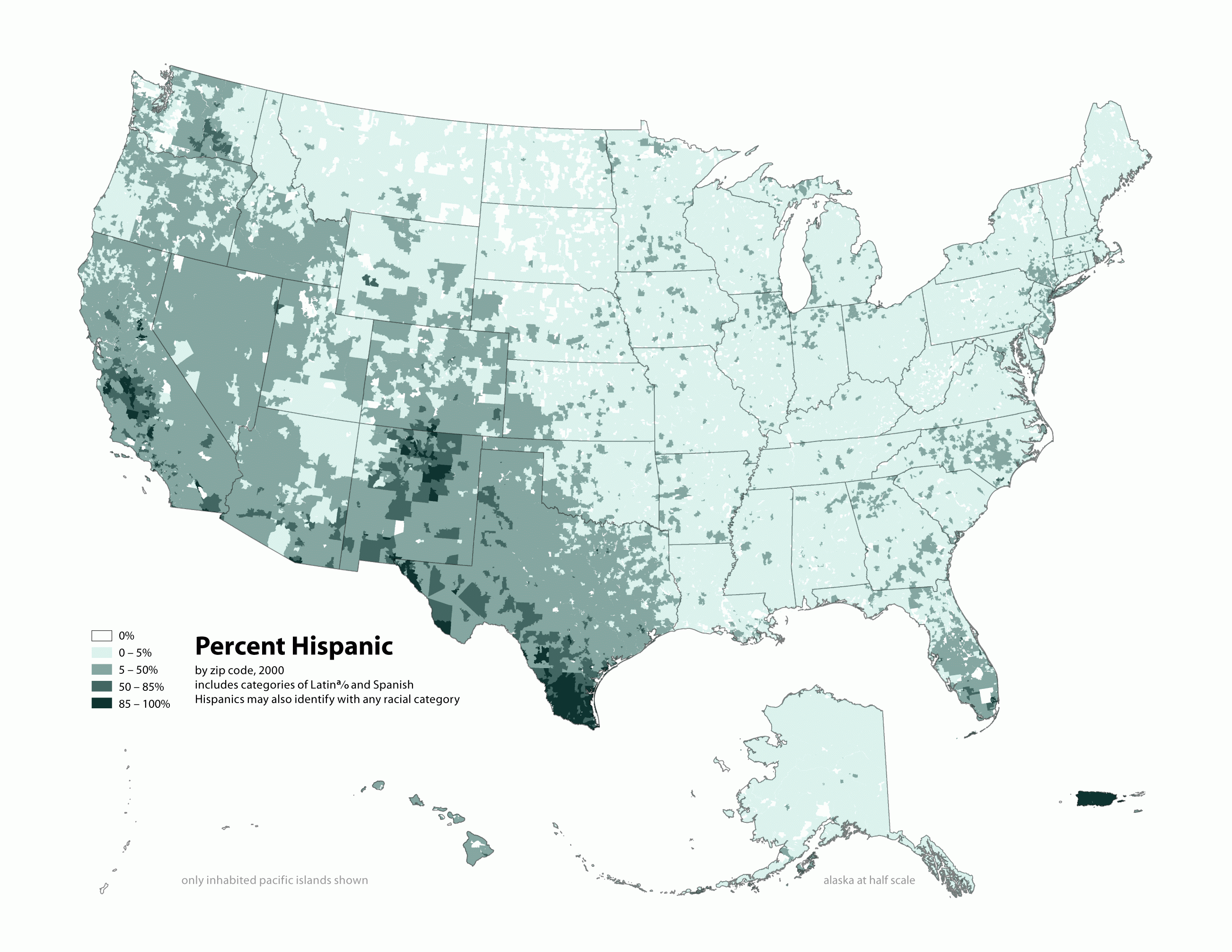
English: Map of contiguous US, showing percentage of population self-reporting as "Hispanic," by census tract, 2000. Data source: US Census. |
| Date | 3 April 2006 (original upload date) |
| Source | Own work |
| Author |
similar maps:
- Image:New 2000 asian density.gif
- Image:New 2000 asian percent.gif
- Image:New 2000 black density.gif
- Image:New 2000 black percent.gif
- Image:New 2000 hawaiian density.gif
- Image:New 2000 hawaiian percent.gif
- Image:New 2000 hispanic density.gif
- Image:New 2000 hispanic percent.gif
- Image:New 2000 indian density.gif
- Image:New 2000 indian percent.gif
- Image:New 2000 white density.gif
- Image:New 2000 white percent.gif
Licensing
This file is licensed under the Creative Commons Attribution-Share Alike 2.5 Generic license.
- You are free:
- to share – to copy, distribute and transmit the work
- to remix – to adapt the work
- Under the following conditions:
- attribution – You must give appropriate credit, provide a link to the license, and indicate if changes were made. You may do so in any reasonable manner, but not in any way that suggests the licensor endorses you or your use.
- share alike – If you remix, transform, or build upon the material, you must distribute your contributions under the same or compatible license as the original.
Original upload log
Transferred from en.wikipedia to Commons using For the Common Good.
The original description page was here. All following user names refer to en.wikipedia.
| Date/Time | Dimensions | User | Comment |
|---|---|---|---|
| 19:17, 1 May 2010 | 2,604 × 2,012 (701,113 bytes) | w:en:Citynoise (talk | contribs) | (Added Alaska, Hawaii, and Territories. Also changed from tracts to zip codes.) |
| 02:08, 3 April 2006 | 1,012 × 691 (72,987 bytes) | w:en:Citynoise (talk | contribs) | (Map of contiguous US, showing percentage of population self-reporting as "Hispanic," in persons per square mile, by census tract, 2000. Data source: US Census. I am the designer and creator of this map and license it under the Creative Commons Attribu) |
File history
Click on a date/time to view the file as it appeared at that time.
| Date/Time | Thumbnail | Dimensions | User | Comment | |
|---|---|---|---|---|---|
| current | 15:11, 10 February 2013 | | 2,604 × 2,012 (685 KB) | Fredlyfish4 | Transferred from en.wikipedia: see original upload log above |
File usage
The following pages on the English Wikipedia use this file (pages on other projects are not listed):
Global file usage
The following other wikis use this file:
- Usage on es.wikipedia.org
- Usage on fa.wikipedia.org
- Usage on ru.wikipedia.org
- Usage on tl.wikipedia.org
- Usage on uz.wikipedia.org