Original file (840 × 1,200 pixels, file size: 224 KB, MIME type: image/jpeg)
| Description |
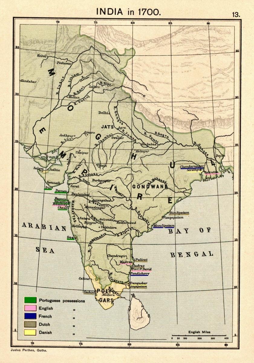
Map of India 1700 showing the Mughal Empire and European trading posts/factory towns from: Joppen, Charles [SJ.] (1907), A Historical Atlas of India for the use of High-Schools, Colleges, and Private Students, London, New York, Bombay, and Calcutta: Longman Green and Co. Pp. 16, 26 maps. Scanned from personal copy, reduced, and highlighted by Fowler&fowler«Talk» 23:38, 24 February 2009 (UTC) |
|---|---|
| Source |
Joppen, Charles [SJ.] (1907), A Historical Atlas of India for the use of High-Schools, Colleges, and Private Students, London, New York, Bombay, and Calcutta: Longman Green and Co. Pp. 16, 26 maps |
| Date |
1907 |
| Author |
Justus Perthes, Gotha./Charles Joppen |
| Permission (Reusing this file) |
See below.
|
Please do not transfer to Wikimedia Commons without my permission (for example, if I am on Wikibreak, then please wait for my return) and without making sure that you have the correct uploading information. Fowler&fowler«Talk» 18:43, 8 June 2009 (UTC)
File history
Click on a date/time to view the file as it appeared at that time.
| Date/Time | Thumbnail | Dimensions | User | Comment | |
|---|---|---|---|---|---|
| current | 16:17, 18 April 2010 | | 840 × 1,200 (224 KB) | Beao (talk | contribs) | Removed watermark. |
| 23:38, 24 February 2009 |  | 840 × 1,200 (204 KB) | Fowler&fowler (talk | contribs) | {{Information |Description=Map of India 1700 showing the Mughal Empire and European trading posts/factory towns from: {{Harvard reference|last=Joppen|first=Charles [SJ.]|year=1907|title=A Historical Atlas of India for the use of High-Schools, Colleges, an |
You cannot overwrite this file.
File usage
The following file is a duplicate of this file (more details):
- File:Joppen1907India1700a.jpg from Commons
- Golden Age of India
- History of India
- History of Pakistan
- Mughal Empire
- Muslim conquests in the Indian subcontinent
- Polygar
- Presidencies and provinces of British India
- Two-nation theory
- Uzbeks in Pakistan
- Talk:Mughal Empire/Archive 4
- User:Falcaorib
- User:Fowler&fowler
- User:Կիմա34/sandbox
- Wikipedia:Reference desk/Archives/Humanities/2020 December 22
- Wikipedia:VideoWiki/Biryani