
Size of this preview: 390 × 599 pixels. Other resolutions: 156 × 240 pixels | 313 × 480 pixels | 500 × 768 pixels | 667 × 1,024 pixels | 2,065 × 3,169 pixels.
Original file (2,065 × 3,169 pixels, file size: 409 KB, MIME type: image/jpeg)
| Description |
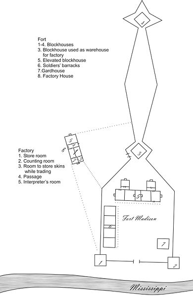
English: John Johnson's 1810 map of Fort Madison. Johnson was the U.S. trading factor. Appears in contributor's book : Frontier Forts of Iowa, p.61, ISBN 9781587298820 |
||||
| Date | Original Map dates from 1810 | ||||
| Source | Traced by the contributor, spelling as in original. | ||||
| Author | |||||
| Permission (Reusing this file) |
|
||||
File history
Click on a date/time to view the file as it appeared at that time.
| Date/Time | Thumbnail | Dimensions | User | Comment | |
|---|---|---|---|---|---|
| current | 14:42, 14 April 2009 | | 2,065 × 3,169 (409 KB) | File Upload Bot (Magnus Manske) | {{BotMoveToCommons|en.wikipedia|year={{subst:CURRENTYEAR}}|month={{subst:CURRENTMONTHNAME}}|day={{subst:CURRENTDAY}}}} {{Information |Description={{en|John Johnson's 1810 map of Fort Madison. Johnson was the U.S. trading factor. Traced by the contributor |
File usage
The following pages on the English Wikipedia use this file (pages on other projects are not listed):
Global file usage
The following other wikis use this file:
- Usage on azb.wikipedia.org
- Usage on ca.wikipedia.org
- Usage on de.wikipedia.org
- Usage on es.wikipedia.org
- Usage on fr.wikipedia.org
- Usage on gd.wikipedia.org
- Usage on gu.wikipedia.org
- Usage on it.wikipedia.org
- Usage on ja.wikipedia.org
- Usage on kn.wikipedia.org
- Usage on ko.wikipedia.org
- Usage on pt.wikipedia.org
- Usage on ro.wikipedia.org
- Usage on vi.wikipedia.org
- Usage on www.wikidata.org
- Usage on zh.wikipedia.org