
Size of this PNG preview of this SVG file: 800 × 465 pixels. Other resolutions: 320 × 186 pixels | 640 × 372 pixels | 1,024 × 595 pixels | 1,280 × 744 pixels | 2,560 × 1,488 pixels | 1,020 × 593 pixels.
Original file (SVG file, nominally 1,020 × 593 pixels, file size: 29 KB)
Summary
| U.S. presidential election maps (SVG) |
| See also: National Atlas maps (png) |
|
1789 · 1792 · 1796 · 1800 · 1804 · 1808 · 1812 · 1816 · 1820 · 1824 · 1828 · 1832 · 1836 · 1840 · 1844 · 1848 · 1852 · 1856 · 1860 · 1864 · 1868 · 1872 · 1876 · 1880 · 1884 · 1888 · 1892 · 1896 · 1900 · 1904 · 1908 · 1912 · 1916 · 1920 · 1924 · 1928 · 1932 · 1936 · 1940 · 1944 · 1948 · 1952 · 1956 · 1960 · 1964 · 1968 · 1972 · 1976 · 1980 · 1984 · 1988 · 1992 · 1996 · 2000 · 2004 · 2008 · 2012 · 2016 · 2020 · 2024 |
| Description |
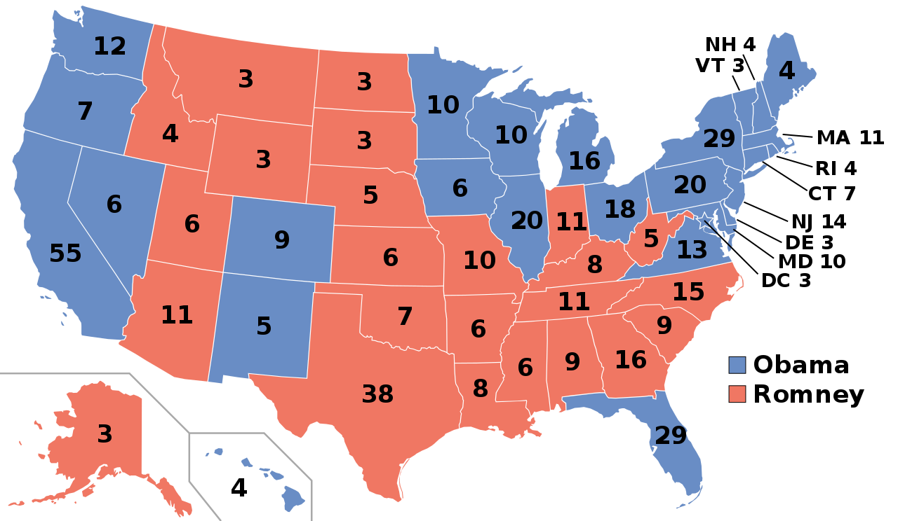
English: Electoral college map for the 2012 United States presidential election (note: Nebraska and Maine split their EVs by congressional district).
Sources used: Pollster.com, CNN.com, MSNBC.com, AP.org, and FOXNews.com |
||
| Date | |||
| Source | Own work | ||
| Author | Gage | ||
| Permission (Reusing this file) |
|
||
| Other versions |
Electoral College 2012.svg: |
||
| SVG development | This map was created with an unknown SVG tool. |
File history
Click on a date/time to view the file as it appeared at that time.
| Date/Time | Thumbnail | Dimensions | User | Comment | |
|---|---|---|---|---|---|
| current | 02:55, 20 November 2018 | | 1,020 × 593 (29 KB) | Newfraferz87 | Simplify further: coordinates & fills, following this |
| 14:48, 18 January 2017 |  | 1,020 × 593 (35 KB) | Newfraferz87 | Clearer state borders | |
| 13:50, 22 July 2016 |  | 1,020 × 593 (35 KB) | Newfraferz87 | Group fonts | |
| 07:18, 12 July 2016 |  | 1,020 × 593 (36 KB) | Newfraferz87 | Adjust frames | |
| 14:12, 10 July 2016 |  | 1,020 × 593 (36 KB) | Newfraferz87 | Adjust legend | |
| 14:06, 10 July 2016 |  | 1,020 × 593 (36 KB) | Newfraferz87 | Overhaul, based on blank states map. Adjust there if there are outstanding border/boundary issues. Thanks | |
| 05:52, 10 November 2012 |  | 1,020 × 593 (112 KB) | Denelson83 | Reverted to version as of 01:10, 9 November 2012: Florida has officially been given to Obama | |
| 11:23, 9 November 2012 |  | 1,020 × 593 (116 KB) | Words in the Wind | Reverted to version as of 01:29, 9 November 2012 Florida is leaning democratic, yet to be conceded. not republican | |
| 11:12, 9 November 2012 |  | 1,020 × 593 (116 KB) | M0tty | Update Floride | |
| 01:29, 9 November 2012 |  | 1,020 × 593 (116 KB) | Gwickwire | Reverted to version as of 00:07, 9 November 2012 doesn't matter, doesn't mean obama has won. just cause romney conceded doesnt mean votes are all counted and obama has more votes. |
.svg)
File usage
The following pages on the English Wikipedia use this file (pages on other projects are not listed):
- 2012 American Samoa Republican presidential caucuses
- 2012 Guam Republican presidential caucuses
- 2012 Northern Mariana Islands Republican presidential caucuses
- 2012 Puerto Rico Republican presidential primary
- 2012 U.S. Virgin Islands Republican presidential caucuses
- 2012 United States elections
- 2012 United States presidential election
- 2012 United States presidential election in Alabama
- 2012 United States presidential election in Alaska
- 2012 United States presidential election in Arizona
- 2012 United States presidential election in Arkansas
- 2012 United States presidential election in California
- 2012 United States presidential election in Colorado
- 2012 United States presidential election in Connecticut
- 2012 United States presidential election in Delaware
- 2012 United States presidential election in Florida
- 2012 United States presidential election in Georgia
- 2012 United States presidential election in Hawaii
- 2012 United States presidential election in Idaho
- 2012 United States presidential election in Illinois
- 2012 United States presidential election in Indiana
- 2012 United States presidential election in Iowa
- 2012 United States presidential election in Kansas
- 2012 United States presidential election in Kentucky
- 2012 United States presidential election in Louisiana
- 2012 United States presidential election in Maine
- 2012 United States presidential election in Maryland
- 2012 United States presidential election in Massachusetts
- 2012 United States presidential election in Michigan
- 2012 United States presidential election in Minnesota
- 2012 United States presidential election in Mississippi
- 2012 United States presidential election in Missouri
- 2012 United States presidential election in Montana
- 2012 United States presidential election in Nebraska
- 2012 United States presidential election in Nevada
- 2012 United States presidential election in New Hampshire
- 2012 United States presidential election in New Jersey
- 2012 United States presidential election in New Mexico
- 2012 United States presidential election in New York
- 2012 United States presidential election in North Carolina
- 2012 United States presidential election in North Dakota
- 2012 United States presidential election in Ohio
- 2012 United States presidential election in Oklahoma
- 2012 United States presidential election in Oregon
- 2012 United States presidential election in Pennsylvania
- 2012 United States presidential election in Rhode Island
- 2012 United States presidential election in South Carolina
- 2012 United States presidential election in South Dakota
- 2012 United States presidential election in Tennessee
- 2012 United States presidential election in Texas
- 2012 United States presidential election in Utah
- 2012 United States presidential election in Vermont
- 2012 United States presidential election in Virginia
- 2012 United States presidential election in Washington (state)
- 2012 United States presidential election in West Virginia
- 2012 United States presidential election in Wisconsin
- 2012 United States presidential election in Wyoming
- 2012 United States presidential election in the District of Columbia
- 2012 in the United States
- Barack Obama
- Electoral history of Barack Obama
- Electoral history of Joe Biden
- Electoral history of Mitt Romney
- Electoral history of Paul Ryan
- Electoral vote changes between United States presidential elections
- List of United States presidential election results by state
- Mitt Romney
- Political colour
- Presidency of Barack Obama
- Tipping-point state
- United States presidential election
- Talk:United States/Archive 79
- User:2002crash1/sandbox
- User:Ajzahuranec/sandbox
- User:Atomic6969420/sandbox
- User:Chennai94/sandbox
- User:ChristianCoke/sandbox
- User:DukeOfDelTaco/U.S. Presidential Elections
- User:DukeOfDelTaco/sandbox/Results of the 2012 United States presidential election
- User:Dull Establishment/sandbox
- User:GDubuc (WMF)/Barack Obama
- User:GDubuc (WMF)/sandbox/Barack Obama
- User:Heatcharger1/sandbox
- User:Hogne/us electioons
- User:JRogyRogy/sandbox
- User:JoshRamirez29/sandbox
- User:Just a sussy baka/sandbox
- User:QuailWatts/sandbox7
- User:QuanticEdit/sandbox
- User:SVeach94/sandbox
- User:Sandbox user 11/sandbox
- User:Sicshisname/sandbox
- User:TheVirginiaHistorian/sandbox
- User:Ty3718
- User:Ziemniak12/sandbox
- Wikipedia:Graphics Lab/Map workshop/Archive/Jan 2013
- Template:2012 United States presidential election imagemap
- Template:State results of the 2012 U.S. presidential election
Global file usage
The following other wikis use this file:
- Usage on af.wikipedia.org
- Usage on ar.wikipedia.org
- Usage on arz.wikipedia.org
- Usage on be.wikipedia.org
- Usage on bg.wikipedia.org
- Usage on bn.wikipedia.org
- Usage on bo.wikipedia.org
- Usage on bs.wikipedia.org
- Usage on ca.wikipedia.org
- Usage on ca.wikinews.org
- Usage on cdo.wikipedia.org
- Usage on cs.wikipedia.org
- Usage on cy.wikipedia.org
- Usage on da.wikipedia.org
- Usage on de.wikipedia.org
- Usage on el.wikipedia.org
- Usage on en.wikibooks.org
- Usage on es.wikipedia.org
- Usage on es.wikinews.org
- Usage on es.wikivoyage.org
- Usage on et.wikipedia.org
- Usage on eu.wikipedia.org
- Usage on fa.wikipedia.org
- Usage on fi.wikipedia.org
- Usage on fi.wikinews.org
- Usage on fo.wikipedia.org
- Usage on frr.wikipedia.org
- Usage on fr.wikipedia.org
View more global usage of this file.