Size of this preview: 800 × 547 pixels. Other resolutions: 320 × 219 pixels | 640 × 437 pixels.
Original file (878 × 600 pixels, file size: 121 KB, MIME type: image/png)
Summary[edit]
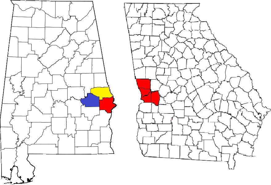
| Description |
Locator map of the Columbus, Georgia metropolitan area. The three components of the CSA are each colored separately: Columbus, Georgia metropolitan area: red Auburn, Alabama metropolitan area: yellow Tuskegee Micropolitan Statistical Area. |
|---|---|
| Source |
Maps created by the United States Census Bureau |
| Date |
09/10/2009 |
| Author | |
| Permission (Reusing this file) |
See below.
|
Licensing:[edit]
File history
Click on a date/time to view the file as it appeared at that time.
| Date/Time | Thumbnail | Dimensions | User | Comment | |
|---|---|---|---|---|---|
| current | 18:00, 31 January 2010 | | 878 × 600 (121 KB) | Shark96z (talk | contribs) | Added the Tuskegee micro area. |
| 16:46, 10 September 2009 |  | 878 × 600 (97 KB) | Shark96z (talk | contribs) | Fix. | |
| 16:36, 10 September 2009 |  | 995 × 600 (100 KB) | Shark96z (talk | contribs) | I uploaded the wrong file. | |
| 16:35, 10 September 2009 |  | 424 × 503 (40 KB) | Shark96z (talk | contribs) | {{Information |Description=Locator map of the Columbus, Georgia metropolitan area. The two components of the CSA are colored separately: *[[Columbus, Georgia metropolitan area}}: red *Auburn, Alabama metropolitan area: yellow |Source= Maps create |
You cannot overwrite this file.
File usage
The following pages on the English Wikipedia use this file (pages on other projects are not listed):
- Auburn, Alabama
- Auburn metropolitan area, Alabama
- Beauregard, Alabama
- Bee Hive, Alabama
- Beulah, Alabama
- Buena Vista, Georgia
- Cataula, Georgia
- Chambers County, Alabama
- Chattahoochee County, Georgia
- Columbus, Georgia
- Columbus metropolitan area, Georgia
- Columbus–Auburn–Opelika combined statistical area
- Cusseta, Georgia
- Ellerslie, Georgia
- Fort Benning South, Georgia
- Fort Mitchell, Alabama
- Fort Moore
- Fortson, Georgia
- Glenville, Alabama
- Gold Hill, Alabama
- Hamilton, Georgia
- Harris County, Georgia
- Holy Trinity, Alabama
- Hopewell, Harris County, Georgia
- Hurtsboro, Alabama
- Juniper, Georgia
- Ladonia, Alabama
- Lee County, Alabama
- Loachapoka, Alabama
- Marion County, Georgia
- Marvyn, Alabama
- Midland, Columbus, Georgia
- Muscogee County, Georgia
- Notasulga, Alabama
- Opelika, Alabama
- Ossahatchie, Georgia
- Phenix City, Alabama
- Pine Mountain, Harris County, Georgia
- Rehoboth, Harris County, Georgia
- Ridgeway, Georgia
- Roxana, Alabama
- Russell County, Alabama
- Salem, Alabama
- Seale, Alabama
- Shiloh, Georgia
- Smiths Station, Alabama
- The Bottle, Alabama
- Upatoi, Georgia
- Valley, Alabama
- Waverly, Alabama
- Waverly Hall, Georgia
- West Point, Georgia
- Whitesville, Georgia
- Template:Columbus Auburn Opelika
- Category:Columbus metropolitan area, Georgia