Legality of Cannabis by U.S. Jurisdiction

Original file(2,407 × 2,115 pixels, file size: 1.07 MB, MIME type: image/png)

Description
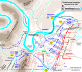
English: Map of part of the Chattanooga Campaign (the Battles for Chattanooga, Nov. 24-25, 1863) of the American Civil War. Drawn in Adobe Illustrator CS5 by Hal Jespersen. Graphic source file is available at http://www.posix.com/CWmaps/
Date
Source Own work
Author Hal Jespersen at en.wikipedia
Permission
(Reusing this file)
Hal Jespersen at en.wikipedia, the copyright holder of this work, hereby publishes it under the following license:
w:en:Creative Commons
attribution
This file is licensed under the Creative Commons Attribution 3.0 Unported license.
Attribution: Map by Hal Jespersen, www.posix.com/CW
You are free:
  • to share – to copy, distribute and transmit the work
  • to remix – to adapt the work
Under the following conditions:
  • attribution – You must give appropriate credit, provide a link to the license, and indicate if changes were made. You may do so in any reasonable manner, but not in any way that suggests the licensor endorses you or your use.
Other versions


Original upload log

The original description page was here. All following user names refer to en.wikipedia.
  • 2009-11-19 17:02 Hlj 2405×2110× (946396 bytes) Updated Osterhaus's movement, based on 1896 War Dept map, available at http://historicalcharts.noaa.gov/historicals/historical_zoom.asp (map CWCK8 in the Tennessee series of CW maps). Same license.
  • 2009-01-31 22:59 Hlj 2405×2110× (939930 bytes) Some more minor tactical updates. Same license as before. {{cc-by-3.0|Map by Hal Jespersen, www.posix.com/CW}}
  • 2009-01-18 20:45 Hlj 2405×2110× (940764 bytes) Some minor tactical updates. Same license as before. {{cc-by-3.0|Map by Hal Jespersen, www.posix.com/CW}}
  • 2009-01-10 01:34 Hlj 2405×2110× (932204 bytes) {{Information |Description=Map of part of the [[Chattanooga Campaign]] (the Battles for Chattanooga, Nov. 24-25, 1863) of the [[American Civil War]]. Drawn in Adobe Illustrator CS3 by Hal Jespersen. Graphic source file is available at http://www.posix.com

Captions

Add a one-line explanation of what this file represents

Items portrayed in this file

depicts

copyright license

Creative Commons Attribution 3.0 Unported

inception

9 January 2009

source of file

original creation by uploader

MIME type

image/png

checksum

90f886afc0b411e5973ef5207212d94e7734b44a

determination method: SHA-1

data size

1,121,536 byte

height

2,115 pixel

width

2,407 pixel

File history

Click on a date/time to view the file as it appeared at that time.

Date/TimeThumbnailDimensionsUserComment
current23:33, 30 March 2011Thumbnail for version as of 23:33, 30 March 20112,407 × 2,115 (1.07 MB)HljUpdated graphical format of rivers and roads. Same license.
15:00, 24 January 2010Thumbnail for version as of 15:00, 24 January 20102,405 × 2,110 (924 KB)BotMultichill {{BotMoveToCommons|en.wikipedia|year={{subst:CURRENTYEAR}}|month={{subst:CURRENTMONTHNAME}}|day={{subst:CURRENTDAY}}}} {{Information |Description={{en|Map of part of the en:Chattanooga Campaign (the Battles for Chattanooga, Nov. 24-25, 1863) of th
The following pages on the English Wikipedia use this file (pages on other projects are not listed):

Global file usage