| Dick's Knob | |
|---|---|
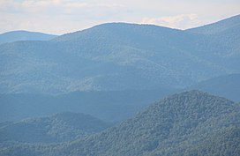
 Dick's Knob viewed from Black Rock Mountain State Park | |
| Highest point | |
| Elevation | 4,620 ft (1,410 m) |
| Coordinates | 34°59′08″N 83°31′18″W / 34.98556°N 83.52167°W |
| Geography | |
| Location | Rabun County, Georgia, U.S. |
| Parent range | Blue Ridge Mountains |
| Topo map | USGS Hightower Bald |
| Climbing | |
| First ascent | unknown |
| Easiest route | Hike |
Dick's Knob or Dicks Knob,[1] with an elevation of 4,620 feet (1,408 m), is the third-highest peak in the State of Georgia if using a 200 ft. (61 m) prominence rule. It is located in Rabun County, Georgia within the Southern Nantahala Wilderness and is the second-highest mountain in the county.
Mountain[edit]
Dick's Knob is located in the Southern Nantahala Wilderness in the Chattahoochee National Forest on Pot Gap Ridge near the North Carolina border.[2] The summit is located 0.5 miles (0.80 km) south of the North Carolina border, 2 miles (3.2 km) east of Tate City and 10 miles (16 km) northwest of Clayton. Nearby geographical features include the Tallulah River, Standing Indian Mountain and Grassy Ridge.[3] Dicks Knob is part of the southern Crystalline Appalachians.[4] A dwarfed oak forest covers the mountain's summit.[5]
The summit of Dick's Knob was burned during the 2016 Rock Mountain Fire.[6]
Hiking[edit]
No trails pass over Dick's Knob's summit. However, the mountain can be reached by hiking off-trail south from the Appalachian Trail at Beech Gap or east from the Tate Branch Campground near Tate City.[7][8]
See also[edit]
References[edit]
- ^ Feature Detail Report for: Dicks Knob. USGS.gov. Retrieved 21 May 2016.
- ^ Dick’s Knob. explorerabun.com. Retrieved 21 May 2016.
- ^ United States Geological Survey (10 May 2016). Hightower Bald, GA quadrangle (Topographic map). Reston, VA: United States Geological Survey. Retrieved 10 May 2016 – via TopoQuest.
- ^ Edwards, Leslie. Ambrose, Jonathan and Kirkman, L. The Natural Communities of Georgia. 2013. ISBN 0820330213. pp. 50.
- ^ Wharton, Charles. The Natural History of the Georgia Mountains. sherpaguides.com. Retrieved 21 May 2016.
- ^ Rock Mountain Fire InfraRed Map 11/17/16. nwcg.gov. 17 November 2016. Retrieved 17 November 2016.
- ^ Summit GA's Highest Peaks: #3 - Dicks Knob (4620') Archived 2016-08-13 at the Wayback Machine. atlantaoutdoorclub.com. 8 March 2010. Retrieved 21 May 2016.
- ^ Chestnut Mountain and Dick’s Knob Archived 2016-08-13 at the Wayback Machine. atlantaoutdoorclub.com. 23 February 2016. Retrieved 21 May 2016.