Buena Vista, Georgia | |
|---|---|
 Buena Vista in 2012 | |
 Location in Marion County and the state of Georgia | |
| Coordinates: 32°19′6″N 84°30′58″W / 32.31833°N 84.51611°W | |
| Country | United States |
| State | Georgia |
| County | Marion |
| Area | |
| • Total | 3.27 sq mi (8.48 km2) |
| • Land | 3.22 sq mi (8.34 km2) |
| • Water | 0.06 sq mi (0.14 km2) |
| Elevation | 719 ft (219 m) |
| Population | |
| • Total | 1,585 |
| • Density | 492.39/sq mi (190.11/km2) |
| Time zone | UTC-5 (Eastern (EST)) |
| • Summer (DST) | UTC-4 (EDT) |
| ZIP code | 31803 |
| Area code | 229 |
| FIPS code | 13-11728[3] |
| GNIS feature ID | 0354903[4] |
Buena Vista (/ˌbjuːnə ˈvɪstə/ BEW-nə VIS-tə) is a city in Marion County, Georgia, United States. It is part of the Columbus, Georgia-Alabama metropolitan statistical area. The population was 1,585 at the 2020 census,[2] down from 2,173 in 2010. Formerly known as "Pea Ridge", the city changed its name to Buena Vista in honor of Zachary Taylor's victory in the Mexican–American War.[5][6] The city is the county seat of Marion County.[7] It is the birthplace of baseball legend Josh Gibson and Medal of Honor recipient Luther H. Story.
History[edit]
Buena Vista was first settled in 1818 by settlers from Georgia. A postal office was established in 1837, and it was incorporated as a town. In 1850, the seat of Marion County was transferred to Buena Vista from Tazewell. Buena Vista was incorporated as a city in 1891, and again in 1920. In 1906, a major fire destroyed much of Buena Vista, however it was rebuilt with brick soon after. Following the fire, the town received an influx of European immigrants.[8][9]
Geography[edit]
Buena Vista is in central Marion County in western Georgia. Georgia State Routes 26 and 41 cross in the center of town. SR 26 leads west 16 miles (26 km) to Cusseta and southeast 14 miles (23 km) to Ellaville, while SR 41 leads north 19 miles (31 km) to Geneva and south 19 miles (31 km) to Preston. State Route 137 leads northeast 6 miles (10 km) to Tazewell and west-northwest 7 miles (11 km) to Union.[citation needed]
According to the United States Census Bureau, Buena Vista has a total area of 3.3 square miles (8.5 km2), of which 0.06 square miles (0.16 km2), or 1.68%, are water.[1] The city is part of the Flint River watershed. Sitting atop a ridge, it is drained by three separate stream systems. To the northeast is Oochee Creek, an east-flowing tributary of Buck Creek, which runs to the Flint River at Montezuma. The southeast part of the city drains to Muckalee Creek, which joins the Flint River at Albany. The west side of Buena Vista drains to Peacock Ditch, a tributary of Kinchafoonee Creek, which joins Muckalee Creek at Albany.[citation needed]
Demographics[edit]
| Census | Pop. | Note | %± |
|---|---|---|---|
| 1850 | 530 | — | |
| 1870 | 525 | — | |
| 1880 | 529 | 0.8% | |
| 1890 | 788 | 49.0% | |
| 1900 | 1,161 | 47.3% | |
| 1910 | 1,016 | −12.5% | |
| 1920 | 1,230 | 21.1% | |
| 1930 | 1,097 | −10.8% | |
| 1940 | 1,161 | 5.8% | |
| 1950 | 1,428 | 23.0% | |
| 1960 | 1,574 | 10.2% | |
| 1970 | 1,486 | −5.6% | |
| 1980 | 1,544 | 3.9% | |
| 1990 | 1,472 | −4.7% | |
| 2000 | 1,664 | 13.0% | |
| 2010 | 2,173 | 30.6% | |
| 2020 | 1,585 | −27.1% | |
| U.S. Decennial Census[10] | |||
| Race | Num. | Perc. |
|---|---|---|
| White (non-Hispanic) | 317 | 20.0% |
| Black or African American (non-Hispanic) | 970 | 61.2% |
| Native American | 1 | 0.06% |
| Asian | 8 | 0.5% |
| Other/Mixed | 17 | 1.07% |
| Hispanic or Latino | 272 | 17.16% |
As of the 2020 United States census, there were 1,585 people, 722 households, and 478 families residing in the city.
Education[edit]
Marion County School District serves pre-school to grade twelve, and consists of one primary school (grades: pre-k through 5th) and a middle/high school (grades: 6th-12th).[12] The district has 108 full-time teachers and over 1,686 students.[13]
- L. K. Moss Primary School
- Marion County Middle High School—www.marion.k12.ga.us
The Marion County School District is in the process of opening a new middle/high school. The 146,000-square-foot (13,600 m2) structure will sit on 200 acres of land in the middle of the county and is scheduled to open for the 2012–13 school year.
Infrastructure[edit]
The city is served by Georgia State Route 26, Georgia State Route 41, and Georgia State Route 137.
Notable people[edit]
- Josh Gibson, Negro leagues baseball player and Hall of Famer
- Roosevelt Jackson, oldest living Negro leagues baseball player (minor leagues only)[14]
- Eddie Owens Martin, creator of Pasaquan
- Luther H. Story, Korean War Medal of Honor recipient
Gallery[edit]
-
 The Marion County Courthouse is located in Buena Vista. It was added to the National Register of Historic Places on September 18, 1980.
 -
 Buena Vista City Hall
 -
 Buena Vista Post Office (ZIP code: 31803)
 -

-
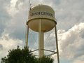 A water tower in Buena Vista proudly proclaims the town to be the "Home of Josh Gibson". The Hall of Famer was born in Buena Vista on December 21, 1911.
 -
 "Pasaquan" is a seven-acre compound near Buena Vista created by outsider artist Eddie Owens Martin (1908-1986), known as "St. EOM". The site is maintained by the Pasaquan Preservation Society. It was added to the National Register of Historic Places on August 27, 2008.
 -
 The Shiloh-Marion Baptist Church and Cemetery, located just south of Buena Vista near the Webster County line, was added to the National Register of Historic Places on May 17, 1984.
 -
 The Drane-Stevens House, located in Buena Vista, was added to the National Register of Historic Places on July 28, 1999.
 -
 The Alfred and Jane Ables House, located in Buena Vista, was added to the National Register of Historic Places on August 9, 2002.


References[edit]
- ^ a b "2022 U.S. Gazetteer Files: Georgia". United States Census Bureau. Retrieved January 23, 2023.
- ^ a b "P1. Race – Buena Vista city, Georgia: 2020 DEC Redistricting Data (PL 94-171)". U.S. Census Bureau. Retrieved January 23, 2023.
- ^ "U.S. Census website". United States Census Bureau. Retrieved January 31, 2008.
- ^ "US Board on Geographic Names". United States Geological Survey. October 25, 2007. Retrieved January 31, 2008.
- ^ Krakow, Kenneth K. (1975). Georgia Place-Names: Their History and Origins (PDF). Macon, GA: Winship Press. p. 28. ISBN 0-915430-00-2.
- ^ [1] New Georgia Encyclopedia, retrieved 20 Aug 2012.
- ^ "Find a County". National Association of Counties. Archived from the original on May 31, 2011. Retrieved June 7, 2011.
- ^ Hellmann, Paul T. (May 13, 2013). Historical Gazetteer of the United States. Routledge. p. 221. ISBN 978-1135948597. Retrieved November 30, 2013.
- ^ topschoolsintheusa. "Buena Vista, Georgia History, Economy and Politics – Top Schools in the USA". Retrieved November 9, 2023.
- ^ "Census of Population and Housing". Census.gov. Retrieved June 4, 2015.
- ^ "Explore Census Data". data.census.gov. Retrieved December 18, 2021.
- ^ Georgia Board of Education[permanent dead link], Retrieved June 23, 2010.
- ^ School Stats, Retrieved June 23, 2010.
- ^ "Oldest Living Member of the Negro Leagues Honored". Waterloo Cedar Falls Courier. July 24, 2011.
Municipalities and communities of Marion County, Georgia, United States | ||
|---|---|---|
| City | 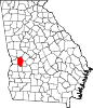 | |
| CDP | ||
| Other unincorporated communities | ||
| Central cities/largest cities |  Columbus, Georgia Metropolitan Statistical Area Auburn, Alabama Metropolitan Statistical Area Tuskegee, Alabama Micropolitan Statistical Area (defunct) | |
|---|---|---|
| Cities in Georgia | ||
| Cities in Alabama | ||
| Counties in Georgia | ||
| Counties in Alabama | ||