Ambrose, Georgia | |
|---|---|
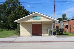
 Ambrose City Hall | |
 Location in Coffee County and the state of Georgia | |
| Coordinates: 31°35′38″N 83°0′57″W / 31.59389°N 83.01583°W | |
| Country | United States |
| State | Georgia |
| County | Coffee |
| Area | |
| • Total | 3.13 sq mi (8.12 km2) |
| • Land | 3.05 sq mi (7.90 km2) |
| • Water | 0.08 sq mi (0.22 km2) |
| Elevation | 308 ft (94 m) |
| Population (2020) | |
| • Total | 327 |
| • Density | 107.21/sq mi (41.39/km2) |
| Time zone | UTC-5 (Eastern (EST)) |
| • Summer (DST) | UTC-4 (EDT) |
| ZIP code | 31512 |
| Area code | 912 |
| FIPS code | 13-02060[2] |
| GNIS feature ID | 0310508[3] |
Ambrose is a city in Coffee County, Georgia, United States. As of the 2020 census, the city had a population of 327.
Geography[edit]
Ambrose is located at 31°35′38″N 83°0′57″W / 31.59389°N 83.01583°W (31.594015, -83.015819).[4]
According to the United States Census Bureau, the city has a total area of 3.1 square miles (8.0 km2), of which 3.1 square miles (8.0 km2) is land and 0.1 square miles (0.26 km2) (1.92%) is water.
Demographics[edit]
| Census | Pop. | Note | %± |
|---|---|---|---|
| 1960 | 244 | — | |
| 1970 | 253 | 3.7% | |
| 1980 | 360 | 42.3% | |
| 1990 | 288 | −20.0% | |
| 2000 | 320 | 11.1% | |
| 2010 | 380 | 18.8% | |
| 2020 | 327 | −13.9% | |
| U.S. Decennial Census[5] | |||
In 2020, its population was 327, down from 380 in 2010.
References[edit]
- ^ "2020 U.S. Gazetteer Files". United States Census Bureau. Retrieved December 18, 2021.
- ^ "U.S. Census website". United States Census Bureau. Retrieved January 31, 2008.
- ^ "US Board on Geographic Names". United States Geological Survey. October 25, 2007. Retrieved January 31, 2008.
- ^ "US Gazetteer files: 2010, 2000, and 1990". United States Census Bureau. February 12, 2011. Retrieved April 23, 2011.
- ^ "Census of Population and Housing". Census.gov. Retrieved June 4, 2015.
