Algund | |
|---|---|
| Gemeinde Algund Comune di Lagundo | |
 | |
Location of Algund  | |
 Algund Location of Algund in Italy  Algund Algund (Trentino-Alto Adige/Südtirol) | |
| Coordinates: 46°41′N 11°8′E / 46.683°N 11.133°E | |
| Country | Italy |
| Region | Trentino-Alto Adige/Südtirol |
| Province | South Tyrol (BZ) |
| Frazioni | Aschbach (Riolagundo), Forst (Foresta), Mitterplars (Plars di Mezzo), Mühlbach (Riomolino), Oberplars (Plars di Sopra) and Vellau (Velloi) |
| Government | |
| • Mayor | Ulrich Gamper |
| Area | |
| • Total | 23.6 km2 (9.1 sq mi) |
| Population (Dec. 2015)[2] | |
| • Total | 5.029 |
| • Density | 0.21/km2 (0.55/sq mi) |
| Demonyms | German: Algunder Italian: lagundesi |
| Time zone | UTC+1 (CET) |
| • Summer (DST) | UTC+2 (CEST) |
| Postal code | 39022 |
| Dialing code | 0473 |
| Website | Official website |

Algund (German pronunciation: [alˈgʊnt]; Italian: Lagundo [laˈɡundo]) is a comune (municipality) in South Tyrol in northern Italy, located about 25 kilometres (16 mi) northwest of Bolzano.
Geography[edit]
As of 31 December 2015, it had a population of 5,029 and an area of 23.6 square kilometres (9.1 sq mi).[3]
Algund borders the following municipalities: Lana, Marling, Merano, Naturns, Partschins, Plaus and Tirol.
Frazioni[edit]
The municipality contains the frazioni (subdivisions, mainly villages and hamlets) Aschbach (Riolagundo), Forst (Foresta), Mitterplars (Plars di Mezzo), Mühlbach (Riomolino), Oberplars (Plars di Sopra) and Vellau (Velloi).
History[edit]
Place name[edit]
The name apud Algunde (Latin for close to Algund) appears for the first time in 994.[4]
Coat-of-arms[edit]
The emblem is a barrel of wine, overhanged by a vine-shoot of black grapes, on or bordered by an argent and gules crown gear. The barrel and grapes symbolize the viticulture practiced in the area, the argent and gules indented frame represents the membership to the Tyrol. The emblem was adopted in 1970.[5]
Society[edit]
Linguistic distribution[edit]
According to the 2011 census, 85.17% of the population speak German, 14.58% Italian and 0.25% Ladin as first language.[6]
| Language | 2001[7] | 2011[6] |
|---|---|---|
| German | 86.81% | 85.17% |
| Italian | 12.93% | 14.58% |
| Ladin | 0.26% | 0.25% |
Demographic evolution[edit]
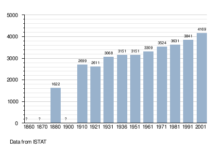
- note: after 1921, the frazione Forst was switched from Marling to Algund.
References[edit]
- ^ "Superficie di Comuni Province e Regioni italiane al 9 ottobre 2011". Italian National Institute of Statistics. Retrieved 16 March 2019.
- ^ "Popolazione Residente al 1° Gennaio 2018". Italian National Institute of Statistics. Retrieved 16 March 2019.
- ^ All demographics and other statistics: Italian statistical institute Istat.
- ^ Egon Kühebacher (1991), Die Ortsnamen Südtirols und ihre Geschichte, Bozen: Athesia, p. 27
- ^ "Heraldry of the World: Algund". Archived from the original on 2012-08-01. Retrieved 2011-05-09.
- ^ a b "Volkszählung 2011/Censimento della popolazione 2011". astat info (38). Provincial Statistics Institute of the Autonomous Province of South Tyrol: 6–7. June 2012. Retrieved 2012-06-14.
- ^ Oscar Benvenuto (ed.): "South Tyrol in Figures 2008", Provincial Statistics Institute of the Autonomous Province of South Tyrol, Bozen/Bolzano 2007, p. 16, table 10
External links[edit]
![]() Media related to Algund at Wikimedia Commons
Media related to Algund at Wikimedia Commons
- (in German and Italian) Homepage of the municipality

| International | |
|---|---|
| National | |